Fulton Topo Map Arkansas
To zoom in, hover over the map of Fulton
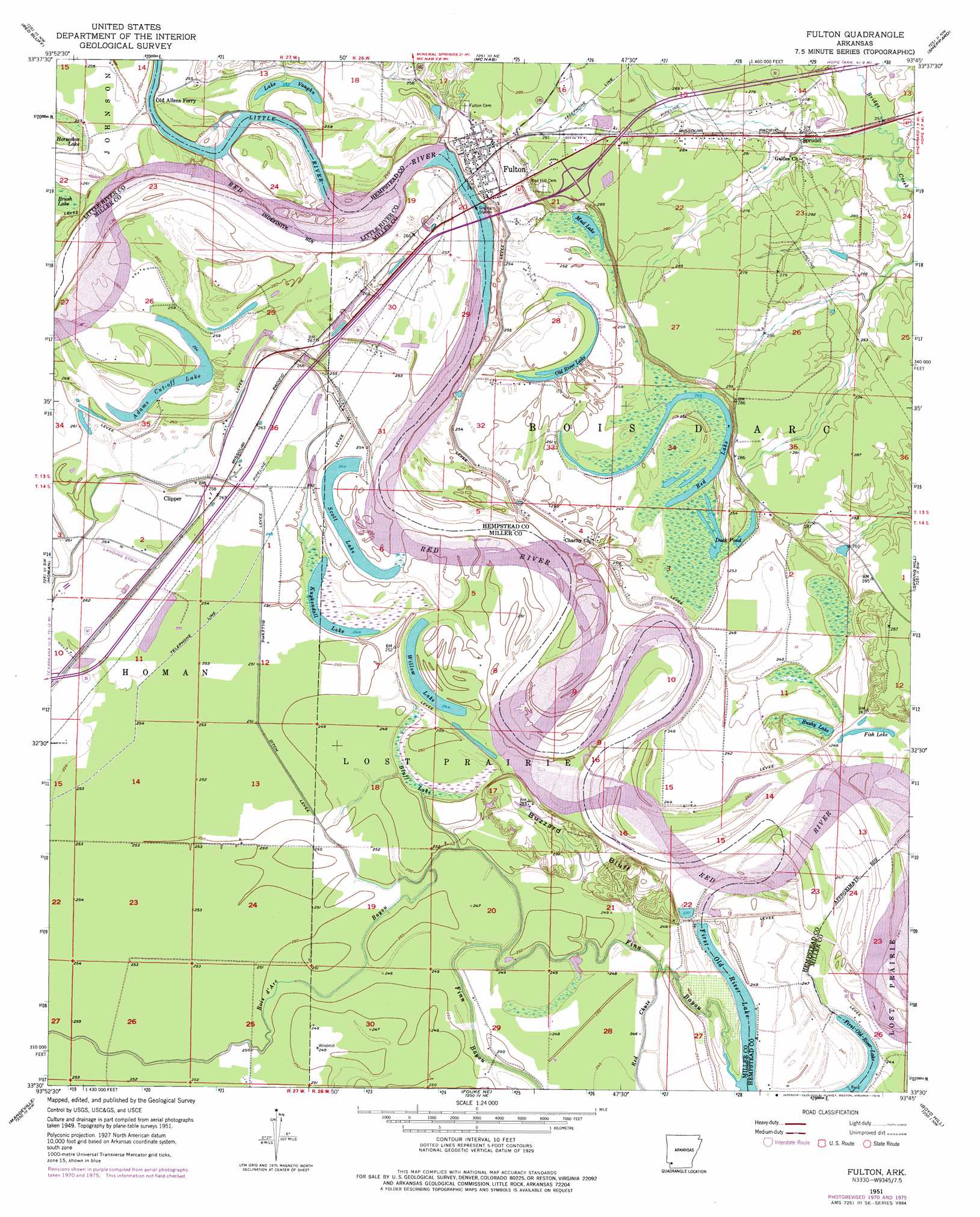
USGS Topo Quad 33093e7 - 1:24,000 scale
| Topo Map Name: | Fulton |
| USGS Topo Quad ID: | 33093e7 |
| Print Size: | ca. 21 1/4" wide x 27" high |
| Southeast Coordinates: | 33.5° N latitude / 93.75° W longitude |
| Map Center Coordinates: | 33.5625° N latitude / 93.8125° W longitude |
| U.S. State: | AR |
| Filename: | o33093e7.jpg |
| Download Map JPG Image: | Fulton topo map 1:24,000 scale |
| Map Type: | Topographic |
| Topo Series: | 7.5´ |
| Map Scale: | 1:24,000 |
| Source of Map Images: | United States Geological Survey (USGS) |
| Alternate Map Versions: |
Fulton AR 1951, updated 1952 Download PDF Buy paper map Fulton AR 1951, updated 1967 Download PDF Buy paper map Fulton AR 1951, updated 1971 Download PDF Buy paper map Fulton AR 1951, updated 1976 Download PDF Buy paper map Fulton AR 1951, updated 1976 Download PDF Buy paper map Fulton AR 2011 Download PDF Buy paper map Fulton AR 2014 Download PDF Buy paper map |
1:24,000 Topo Quads surrounding Fulton
Ben Lomond |
Mineral Springs South |
Columbus |
Washington |
Blevins |
Ashdown East |
Red Bluff |
Mcnab |
Sheppard |
Hope |
Ogden |
Homan |
Fulton |
Spring Hill |
Patmos |
Texarkana |
Mandeville |
Fouke Ne |
Boyd Hill |
Old Town |
Domino |
Fouke |
Fouke Se |
Garland |
Lewisville |
> Back to 33093e1 at 1:100,000 scale
> Back to 33092a1 at 1:250,000 scale
> Back to U.S. Topo Maps home
Fulton topo map: Gazetteer
Fulton: Cliffs
Buzzard Bluff elevation 79m 259′Fulton: Crossings
Interchange 12 elevation 83m 272′Interchange 18 elevation 94m 308′
Fulton: Islands
Summers Island elevation 74m 242′Fulton: Lakes
Adams Cut-off Lake elevation 74m 242′Bushy Lake elevation 74m 242′
Duck Pond elevation 74m 242′
First Old River Lake elevation 72m 236′
Fish Lake elevation 77m 252′
Kuykendall Lake elevation 75m 246′
Lake Vaughn elevation 79m 259′
Mud Lake elevation 77m 252′
Old River Lake elevation 77m 252′
Red Lake elevation 73m 239′
Scott Lake elevation 76m 249′
Willow Lake elevation 75m 246′
Fulton: Populated Places
Clipper elevation 79m 259′Fulton elevation 82m 269′
Sprudel elevation 80m 262′
Fulton: Streams
Bois d'Arc Bayou elevation 76m 249′Finn Bayou elevation 72m 236′
Little River elevation 69m 226′
Fulton: Swamps
Bluff Lake elevation 79m 259′Fulton digital topo map on disk
Buy this Fulton topo map showing relief, roads, GPS coordinates and other geographical features, as a high-resolution digital map file on DVD: