Texarkana Topo Map Texas
To zoom in, hover over the map of Texarkana
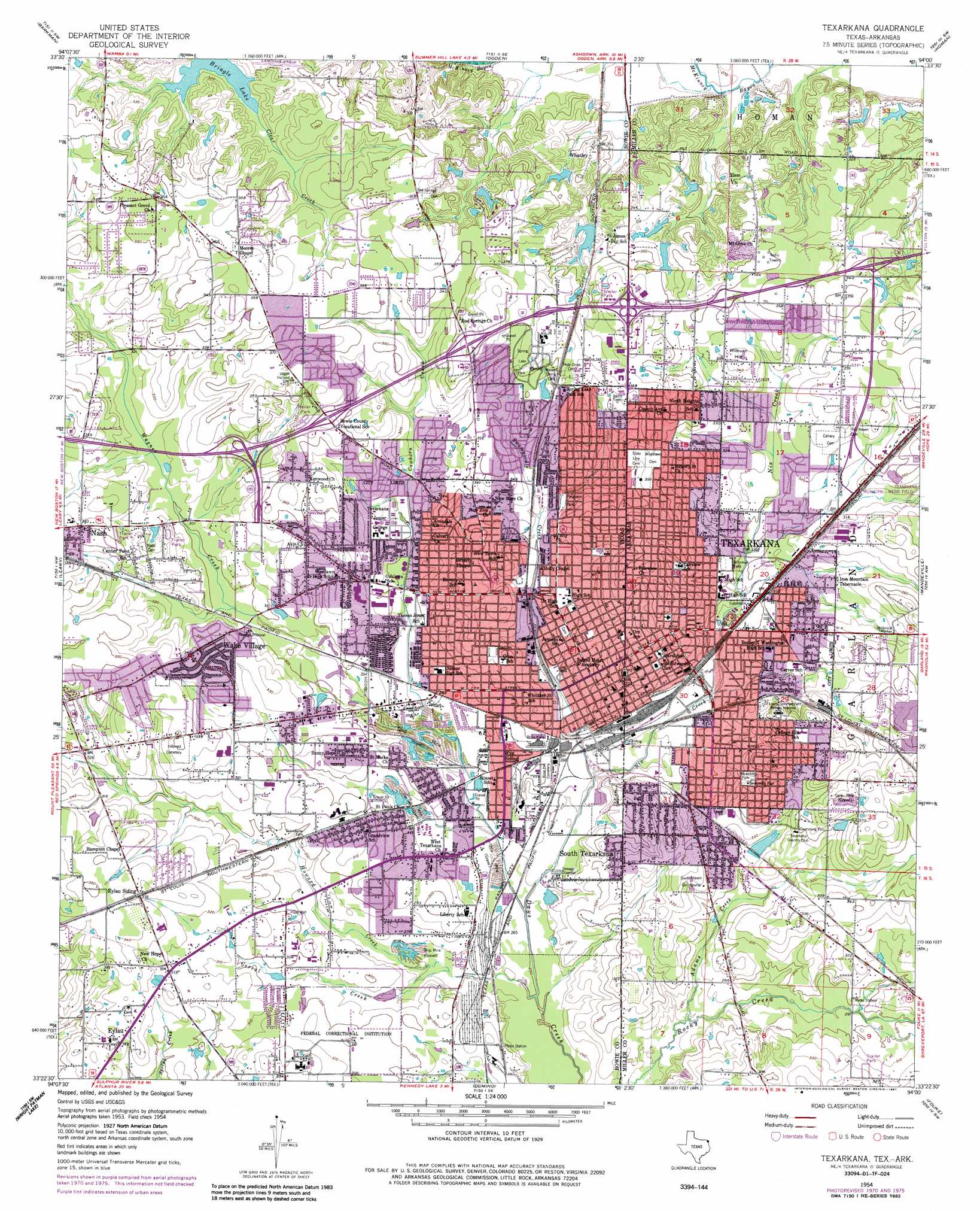
USGS Topo Quad 33094d1 - 1:24,000 scale
| Topo Map Name: | Texarkana |
| USGS Topo Quad ID: | 33094d1 |
| Print Size: | ca. 21 1/4" wide x 27" high |
| Southeast Coordinates: | 33.375° N latitude / 94° W longitude |
| Map Center Coordinates: | 33.4375° N latitude / 94.0625° W longitude |
| U.S. States: | TX, AR |
| Filename: | o33094d1.jpg |
| Download Map JPG Image: | Texarkana topo map 1:24,000 scale |
| Map Type: | Topographic |
| Topo Series: | 7.5´ |
| Map Scale: | 1:24,000 |
| Source of Map Images: | United States Geological Survey (USGS) |
| Alternate Map Versions: |
Texarkana TX 1954, updated 1955 Download PDF Buy paper map Texarkana TX 1954, updated 1965 Download PDF Buy paper map Texarkana TX 1954, updated 1971 Download PDF Buy paper map Texarkana TX 1954, updated 1976 Download PDF Buy paper map Texarkana TX 1954, updated 1987 Download PDF Buy paper map Texarkana TX 1954, updated 1987 Download PDF Buy paper map Texarkana TX 2001, updated 2004 Download PDF Buy paper map Texarkana TX 2011 Download PDF Buy paper map Texarkana TX 2013 Download PDF Buy paper map Texarkana TX 2016 Download PDF Buy paper map |
1:24,000 Topo Quads surrounding Texarkana
Arden |
Ashdown West |
Ashdown East |
Red Bluff |
Mcnab |
Redbank |
Barkman |
Ogden |
Homan |
Fulton |
Hooks |
Leary |
Texarkana |
Mandeville |
Fouke Ne |
Maud |
Wright Patman Dam |
Domino |
Fouke |
Fouke Se |
Douglassville |
Atlanta North |
Bloomburg |
Doddridge Nw |
Doddridge Ne |
> Back to 33094a1 at 1:100,000 scale
> Back to 33094a1 at 1:250,000 scale
> Back to U.S. Topo Maps home
Texarkana topo map: Gazetteer
Texarkana: Airports
Saint Michael Hospital Heliport elevation 104m 341′Shillings Airport elevation 104m 341′
Texarkana: Crossings
Interchange 1 elevation 108m 354′Interchange 2 elevation 109m 357′
Texarkana: Dams
Country Club Lake Dam elevation 95m 311′Mitchell Lake Dam elevation 104m 341′
State Line Lake Dam elevation 94m 308′
Wright Lake Dam elevation 94m 308′
Texarkana: Parks
Bradfield Park elevation 104m 341′Bramble Park elevation 100m 328′
Bramble Park elevation 104m 341′
Buhrman Field elevation 94m 308′
Ferguson Park elevation 97m 318′
George Williams Park elevation 87m 285′
Hobo Jungle Park elevation 86m 282′
Hobo Jungle Park elevation 86m 282′
Hole-In-The-Wall Park elevation 95m 311′
Ingraham Park elevation 97m 318′
Jefferson Park elevation 91m 298′
Kline Park elevation 107m 351′
Lee Park elevation 86m 282′
North Texarkana Park elevation 99m 324′
North Texarkana Park elevation 94m 308′
Razorback Stadium elevation 95m 311′
Spring Lake Park elevation 112m 367′
Texas High School Baseball Field elevation 108m 354′
Tiger Stadium at Grimm Memorial Park elevation 108m 354′
Vera Bradfield Park elevation 94m 308′
Texarkana: Populated Places
Eylau elevation 98m 321′South Texarkana elevation 100m 328′
Texarkana elevation 91m 298′
Texarkana elevation 111m 364′
Wake Village elevation 104m 341′
Whatley elevation 94m 308′
Texarkana: Post Offices
Texarkana Post Office elevation 102m 334′Texarkana: Reservoirs
Country Club Lake elevation 95m 311′Mitchell Lake elevation 104m 341′
State Line Lake elevation 94m 308′
Wright Lake elevation 94m 308′
Texarkana: Streams
Adams Creek elevation 81m 265′Corral Creek elevation 80m 262′
Cowhorn Creek elevation 82m 269′
Howard Creek elevation 76m 249′
Nix Creek elevation 79m 259′
Nix Creek elevation 82m 269′
Swampoodle Creek elevation 79m 259′
Wagner Creek elevation 76m 249′
Texarkana: Summits
Wilburn Hill elevation 108m 354′Texarkana digital topo map on disk
Buy this Texarkana topo map showing relief, roads, GPS coordinates and other geographical features, as a high-resolution digital map file on DVD: