Lydia Topo Map Texas
To zoom in, hover over the map of Lydia
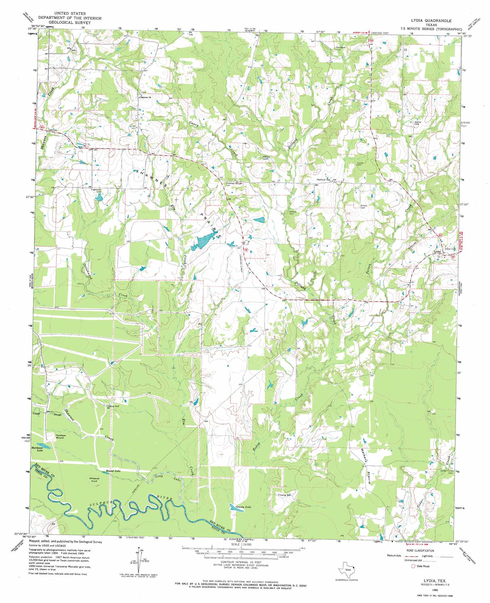
USGS Topo Quad 33094d7 - 1:24,000 scale
| Topo Map Name: | Lydia |
| USGS Topo Quad ID: | 33094d7 |
| Print Size: | ca. 21 1/4" wide x 27" high |
| Southeast Coordinates: | 33.375° N latitude / 94.75° W longitude |
| Map Center Coordinates: | 33.4375° N latitude / 94.8125° W longitude |
| U.S. State: | TX |
| Filename: | o33094d7.jpg |
| Download Map JPG Image: | Lydia topo map 1:24,000 scale |
| Map Type: | Topographic |
| Topo Series: | 7.5´ |
| Map Scale: | 1:24,000 |
| Source of Map Images: | United States Geological Survey (USGS) |
| Alternate Map Versions: |
Lydia TX 1965, updated 1967 Download PDF Buy paper map Lydia TX 2010 Download PDF Buy paper map Lydia TX 2013 Download PDF Buy paper map Lydia TX 2016 Download PDF Buy paper map |
1:24,000 Topo Quads surrounding Lydia
Dimple |
White Rock |
English |
De Kalb Nw |
Tom |
Clarksville |
Annona |
Avery |
Oak Grove |
De Kalb |
Cuthand |
Boxelder |
Lydia |
Hodgson |
Malta |
Talco |
Wilkinson |
Coopers Chapel |
Dalby Springs |
Bassett |
Winfield |
Mount Pleasant |
Cookville |
Naples |
Marietta |
> Back to 33094a1 at 1:100,000 scale
> Back to 33094a1 at 1:250,000 scale
> Back to U.S. Topo Maps home
Lydia topo map: Gazetteer
Lydia: Airports
Keys Ranch Airport elevation 102m 334′Lydia: Dams
Key Lake Dam elevation 99m 324′Lydia: Flats
Shawnee Prairie elevation 104m 341′Walkers Prairie elevation 95m 311′
Lydia: Guts
Cutoff Slough elevation 82m 269′Lydia: Lakes
Grassy Lake elevation 80m 262′Hardison Lake elevation 84m 275′
Long Lake elevation 79m 259′
Round Lake elevation 82m 269′
Lydia: Populated Places
Lydia elevation 114m 374′Lydia: Reservoirs
Key Lake elevation 99m 324′Lydia: Streams
Caney Creek elevation 95m 311′Cottonwood Creek elevation 85m 278′
Dillard Creek elevation 85m 278′
Elm Creek elevation 79m 259′
Peters Creek elevation 89m 291′
Shawnee Creek elevation 79m 259′
Lydia: Summits
Hardison Mound elevation 86m 282′Whiteoak Knoll elevation 84m 275′
Lydia digital topo map on disk
Buy this Lydia topo map showing relief, roads, GPS coordinates and other geographical features, as a high-resolution digital map file on DVD: