Garvin Topo Map Oklahoma
To zoom in, hover over the map of Garvin
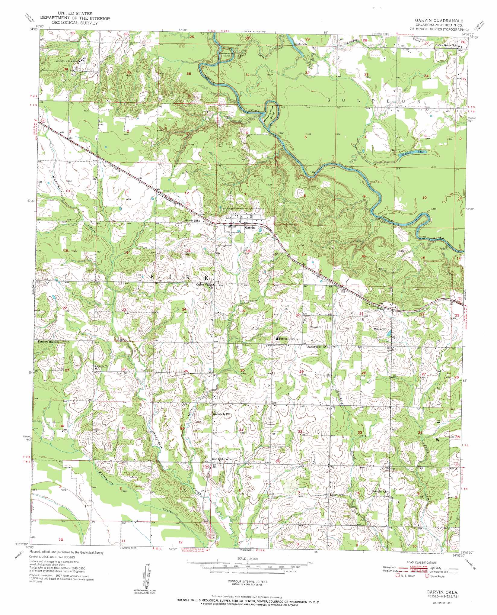
USGS Topo Quad 33094h8 - 1:24,000 scale
| Topo Map Name: | Garvin |
| USGS Topo Quad ID: | 33094h8 |
| Print Size: | ca. 21 1/4" wide x 27" high |
| Southeast Coordinates: | 33.875° N latitude / 94.875° W longitude |
| Map Center Coordinates: | 33.9375° N latitude / 94.9375° W longitude |
| U.S. State: | OK |
| Filename: | o33094h8.jpg |
| Download Map JPG Image: | Garvin topo map 1:24,000 scale |
| Map Type: | Topographic |
| Topo Series: | 7.5´ |
| Map Scale: | 1:24,000 |
| Source of Map Images: | United States Geological Survey (USGS) |
| Alternate Map Versions: |
Garvin OK 1951 Download PDF Buy paper map Garvin OK 2010 Download PDF Buy paper map Garvin OK 2012 Download PDF Buy paper map Garvin OK 2016 Download PDF Buy paper map |
1:24,000 Topo Quads surrounding Garvin
Sobol |
Alikchi |
Bear Mountain |
Old Glory Mountain |
Stephens Gap |
Swink |
Wright City |
Golden |
Steel Junction |
Broken Bow |
Kiomatia |
Millerton |
Garvin |
Idabel |
Shults |
Manchester |
Negley |
Acworth |
Idabel Se |
Haworth |
Bagwell |
Dimple |
White Rock |
English |
De Kalb Nw |
> Back to 33094e1 at 1:100,000 scale
> Back to 33094a1 at 1:250,000 scale
> Back to U.S. Topo Maps home
Garvin topo map: Gazetteer
Garvin: Bends
Possum Ford Bend elevation 111m 364′Garvin: Dams
Oknoname 089001 Dam elevation 140m 459′Oknoname 089005 Dam elevation 138m 452′
Whitegrass-Waterhole Creeks Site 5 Dam elevation 116m 380′
Whitegrass-Waterhole Creeks Site 6 Dam elevation 125m 410′
Whitegrass-Waterhole Creeks Site 7 Dam elevation 131m 429′
Whitegrass-Waterhole Creeks Site 8 Dam elevation 127m 416′
Whitegrass-Waterhole Creeks Site 9 Dam elevation 111m 364′
Garvin: Islands
Rattlesnake Island elevation 111m 364′Garvin: Lakes
Mohawk Lake elevation 106m 347′Sunk Lake elevation 109m 357′
Garvin: Populated Places
Garvin elevation 150m 492′Iron Stob Corner elevation 127m 416′
Garvin: Reservoirs
Oknoname 089001 Reservoir elevation 140m 459′Oknoname 089005 Reservoir elevation 138m 452′
Whitegrass-Waterhole Creeks Site 5 Reservoir elevation 116m 380′
Whitegrass-Waterhole Creeks Site 6 Reservoir elevation 125m 410′
Whitegrass-Waterhole Creeks Site 7 Reservoir elevation 131m 429′
Whitegrass-Waterhole Creeks Site 8 Reservoir elevation 127m 416′
Whitegrass-Waterhole Creeks Site 9 Reservoir elevation 111m 364′
Garvin: Streams
Campbell Creek elevation 103m 337′Garvin Creek elevation 113m 370′
Sunk Lake Slough elevation 103m 337′
Garvin digital topo map on disk
Buy this Garvin topo map showing relief, roads, GPS coordinates and other geographical features, as a high-resolution digital map file on DVD: