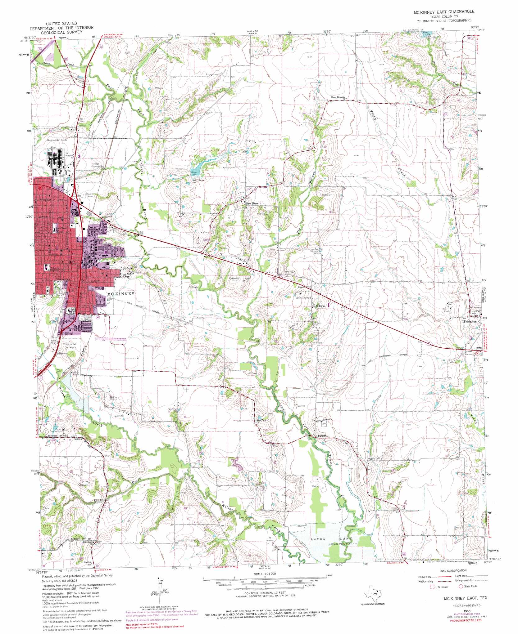
Mckinney East Topo Map Texas
To zoom in, hover over the map of Mckinney East
USGS Topo Quad 33096b5 - 1:24,000 scale
| Topo Map Name: | Mckinney East |
| USGS Topo Quad ID: | 33096b5 |
| Print Size: | ca. 21 1/4" wide x 27" high |
| Southeast Coordinates: | 33.125° N latitude / 96.5° W longitude |
| Map Center Coordinates: | 33.1875° N latitude / 96.5625° W longitude |
| U.S. State: | TX |
| Filename: | o33096b5.jpg |
| Download Map JPG Image: | Mckinney East topo map 1:24,000 scale |
| Map Type: | Topographic |
| Topo Series: | 7.5´ |
| Map Scale: | 1:24,000 |
| Source of Map Images: | United States Geological Survey (USGS) |
| Alternate Map Versions: |
McKinney East TX 1960, updated 1961 Download PDF Buy paper map McKinney East TX 1960, updated 1969 Download PDF Buy paper map McKinney East TX 1960, updated 1977 Download PDF Buy paper map McKinney East TX 1960, updated 1977 Download PDF Buy paper map McKinney East TX 2010 Download PDF Buy paper map McKinney East TX 2013 Download PDF Buy paper map McKinney East TX 2016 Download PDF Buy paper map |
1:24,000 Topo Quads surrounding Mckinney East
Marilee |
Gunter |
Van Alstyne |
Pilot Grove |
Trenton |
Celina |
Weston |
Anna |
Blue Ridge |
Pike |
Frisco |
Mckinney West |
Mckinney East |
Culleoka |
Farmersville |
Hebron |
Plano |
Wylie |
Lavon |
Josephine |
Addison |
Garland |
Rowlett |
Rockwall |
Royse City |
> Back to 33096a1 at 1:100,000 scale
> Back to 33096a1 at 1:250,000 scale
> Back to U.S. Topo Maps home
Mckinney East topo map: Gazetteer
Mckinney East: Airports
Lavon North Airport elevation 170m 557′McKinney Municipal Airport elevation 171m 561′
Square Air Airport elevation 198m 649′
Mckinney East: Dams
Soil Conservation Service Site 12 Dam elevation 171m 561′Soil Conservation Service Site 24 Dam elevation 177m 580′
Soil Conservation Service Site 53 Dam elevation 171m 561′
Mckinney East: Parks
Finch Park elevation 174m 570′Mouzon Park elevation 174m 570′
Mckinney East: Populated Places
Biggers (historical) elevation 188m 616′Lowry Crossing elevation 156m 511′
McKinney elevation 192m 629′
Milligan elevation 169m 554′
New Hope elevation 183m 600′
Mckinney East: Post Offices
Collin County Central Museum at the Old Post Office elevation 180m 590′Mckinney East: Reservoirs
Soil Conservation Service Site 12 Reservoir elevation 171m 561′Soil Conservation Service Site 24 Reservoir elevation 177m 580′
Soil Conservation Service Site 53 Reservoir elevation 171m 561′
Mckinney East: Streams
Big Branch elevation 153m 501′Clemons Creek elevation 162m 531′
Honey Creek elevation 165m 541′
Jeans Creek elevation 164m 538′
Sloan Creek elevation 155m 508′
Mckinney East digital topo map on disk
Buy this Mckinney East topo map showing relief, roads, GPS coordinates and other geographical features, as a high-resolution digital map file on DVD: