Weston Topo Map Texas
To zoom in, hover over the map of Weston
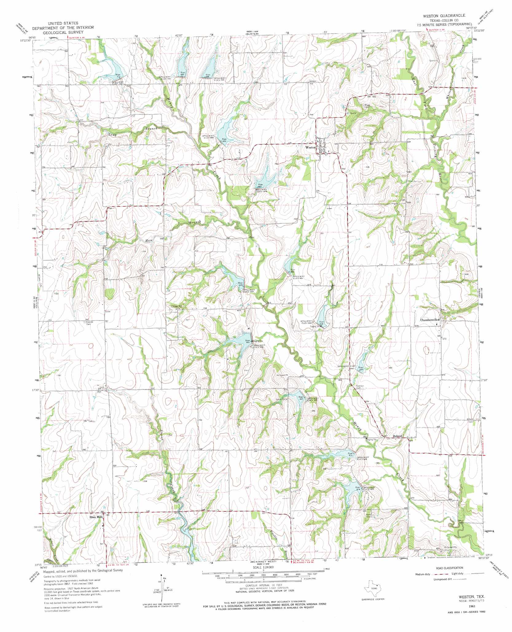
USGS Topo Quad 33096c6 - 1:24,000 scale
| Topo Map Name: | Weston |
| USGS Topo Quad ID: | 33096c6 |
| Print Size: | ca. 21 1/4" wide x 27" high |
| Southeast Coordinates: | 33.25° N latitude / 96.625° W longitude |
| Map Center Coordinates: | 33.3125° N latitude / 96.6875° W longitude |
| U.S. State: | TX |
| Filename: | o33096c6.jpg |
| Download Map JPG Image: | Weston topo map 1:24,000 scale |
| Map Type: | Topographic |
| Topo Series: | 7.5´ |
| Map Scale: | 1:24,000 |
| Source of Map Images: | United States Geological Survey (USGS) |
| Alternate Map Versions: |
Weston TX 1961, updated 1963 Download PDF Buy paper map Weston TX 1961, updated 1975 Download PDF Buy paper map Weston TX 2010 Download PDF Buy paper map Weston TX 2013 Download PDF Buy paper map Weston TX 2016 Download PDF Buy paper map |
1:24,000 Topo Quads surrounding Weston
Collinsville |
Ethel |
Dorchester |
Howe |
Whitewright |
Pilot Point |
Marilee |
Gunter |
Van Alstyne |
Pilot Grove |
Aubrey |
Celina |
Weston |
Anna |
Blue Ridge |
Little Elm |
Frisco |
Mckinney West |
Mckinney East |
Culleoka |
Lewisville East |
Hebron |
Plano |
Wylie |
Lavon |
> Back to 33096a1 at 1:100,000 scale
> Back to 33096a1 at 1:250,000 scale
> Back to U.S. Topo Maps home
Weston topo map: Gazetteer
Weston: Airports
Tallows Field elevation 236m 774′Weston: Dams
Soil Conservation Service Site 10 Dam elevation 196m 643′Soil Conservation Service Site 11 Dam elevation 197m 646′
Soil Conservation Service Site 12 Dam elevation 191m 626′
Soil Conservation Service Site 13 Dam elevation 190m 623′
Soil Conservation Service Site 14 Dam elevation 192m 629′
Soil Conservation Service Site 15 Dam elevation 187m 613′
Soil Conservation Service Site 16 Dam elevation 187m 613′
Soil Conservation Service Site 31 Dam elevation 196m 643′
Soil Conservation Service Site 32 Dam elevation 190m 623′
Soil Conservation Service Site 32a Dam elevation 187m 613′
Soil Conservation Service Site 33 Dam elevation 200m 656′
Soil Conservation Service Site 34 Dam elevation 179m 587′
Soil Conservation Service Site 8a Dam elevation 200m 656′
Soil Conservation Service Site 8b1 Dam elevation 218m 715′
Soil Conservation Service Site 8c Dam elevation 210m 688′
Soil Conservation Service Site 8d Dam elevation 216m 708′
Soil Conservation Service Site 8e Dam elevation 205m 672′
Soil Conservation Service Site 8f Dam elevation 200m 656′
Soil Conservation Service Site 8h Dam elevation 209m 685′
Soil Conservation Service Site 9 Dam elevation 197m 646′
Weston: Parks
Erwin Municipal Park elevation 192m 629′Weston: Populated Places
Chambersville elevation 199m 652′Rhea Mills elevation 224m 734′
Roland elevation 192m 629′
Weston elevation 228m 748′
Weston: Reservoirs
Soil Conservation Service Site 10 Reservoir elevation 196m 643′Soil Conservation Service Site 11 Reservoir elevation 197m 646′
Soil Conservation Service Site 12 Reservoir elevation 191m 626′
Soil Conservation Service Site 13 Reservoir elevation 190m 623′
Soil Conservation Service Site 14 Reservoir elevation 192m 629′
Soil Conservation Service Site 15 Reservoir elevation 187m 613′
Soil Conservation Service Site 16 Reservoir elevation 187m 613′
Soil Conservation Service Site 31 Reservoir elevation 196m 643′
Soil Conservation Service Site 32 Reservoir elevation 190m 623′
Soil Conservation Service Site 32a Reservoir elevation 187m 613′
Soil Conservation Service Site 33 Reservoir elevation 200m 656′
Soil Conservation Service Site 34 Reservoir elevation 179m 587′
Soil Conservation Service Site 8a Reservoir elevation 200m 656′
Soil Conservation Service Site 8b1 Reservoir elevation 218m 715′
Soil Conservation Service Site 8c Reservoir elevation 210m 688′
Soil Conservation Service Site 8d Reservoir elevation 216m 708′
Soil Conservation Service Site 8e Reservoir elevation 205m 672′
Soil Conservation Service Site 8f Reservoir elevation 200m 656′
Soil Conservation Service Site 8h Reservoir elevation 209m 685′
Soil Conservation Service Site 9 Reservoir elevation 197m 646′
Weston: Streams
Haw Branch elevation 187m 613′Long Branch elevation 202m 662′
Whites Creek elevation 179m 587′
Weston: Trails
Erwin Park Trail elevation 208m 682′Weston digital topo map on disk
Buy this Weston topo map showing relief, roads, GPS coordinates and other geographical features, as a high-resolution digital map file on DVD: