Gunter Topo Map Texas
To zoom in, hover over the map of Gunter
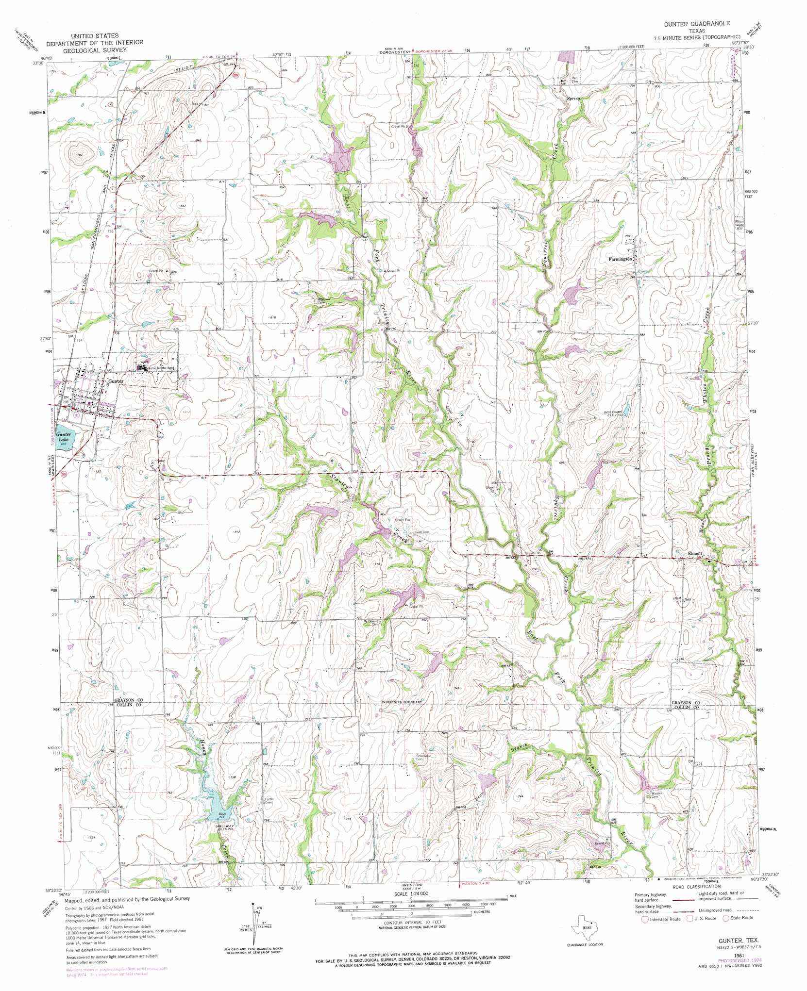
USGS Topo Quad 33096d6 - 1:24,000 scale
| Topo Map Name: | Gunter |
| USGS Topo Quad ID: | 33096d6 |
| Print Size: | ca. 21 1/4" wide x 27" high |
| Southeast Coordinates: | 33.375° N latitude / 96.625° W longitude |
| Map Center Coordinates: | 33.4375° N latitude / 96.6875° W longitude |
| U.S. State: | TX |
| Filename: | o33096d6.jpg |
| Download Map JPG Image: | Gunter topo map 1:24,000 scale |
| Map Type: | Topographic |
| Topo Series: | 7.5´ |
| Map Scale: | 1:24,000 |
| Source of Map Images: | United States Geological Survey (USGS) |
| Alternate Map Versions: |
Gunter TX 1961, updated 1963 Download PDF Buy paper map Gunter TX 1961, updated 1975 Download PDF Buy paper map Gunter TX 2010 Download PDF Buy paper map Gunter TX 2013 Download PDF Buy paper map Gunter TX 2016 Download PDF Buy paper map |
1:24,000 Topo Quads surrounding Gunter
Whitesboro |
Sadler |
Sherman Nw |
Sherman |
Ambrose |
Collinsville |
Ethel |
Dorchester |
Howe |
Whitewright |
Pilot Point |
Marilee |
Gunter |
Van Alstyne |
Pilot Grove |
Aubrey |
Celina |
Weston |
Anna |
Blue Ridge |
Little Elm |
Frisco |
Mckinney West |
Mckinney East |
Culleoka |
> Back to 33096a1 at 1:100,000 scale
> Back to 33096a1 at 1:250,000 scale
> Back to U.S. Topo Maps home
Gunter topo map: Gazetteer
Gunter: Dams
Soil Conservation Service Site 19 Dam elevation 232m 761′Soil Conservation Service Site 20 Dam elevation 226m 741′
Soil Conservation Service Site 20a Dam elevation 229m 751′
Soil Conservation Service Site 21 Dam elevation 224m 734′
Soil Conservation Service Site 22 Dam elevation 220m 721′
Soil Conservation Service Site 26 Dam elevation 210m 688′
Soil Conservation Service Site 26a Dam elevation 227m 744′
Soil Conservation Service Site 26b Dam elevation 219m 718′
Soil Conservation Service Site 27 Dam elevation 202m 662′
Soil Conservation Service Site 28 Dam elevation 211m 692′
Soil Conservation Service Site 29 Dam elevation 206m 675′
Soil Conservation Service Site 29a Dam elevation 195m 639′
Soil Conservation Service Site 30 Dam elevation 198m 649′
Soil Conservation Service Site 35 Dam elevation 219m 718′
Soil Conservation Service Site 35a Dam elevation 236m 774′
Soil Conservation Service Site 36 Dam elevation 226m 741′
Soil Conservation Service Site 37 Dam elevation 221m 725′
Soil Conservation Service Site 38 Dam elevation 237m 777′
Soil Conservation Service Site 8g Dam elevation 222m 728′
Gunter: Populated Places
Elm View elevation 231m 757′Elmont elevation 222m 728′
Farmington elevation 239m 784′
Gunter elevation 215m 705′
Gunter: Reservoirs
Soil Conservation Service Site 19 Reservoir elevation 232m 761′Soil Conservation Service Site 20 Reservoir elevation 226m 741′
Soil Conservation Service Site 20-A Reservoir elevation 229m 751′
Soil Conservation Service Site 21 Reservoir elevation 224m 734′
Soil Conservation Service Site 22 Reservoir elevation 220m 721′
Soil Conservation Service Site 26 Reservoir elevation 210m 688′
Soil Conservation Service Site 26a Reservoir elevation 227m 744′
Soil Conservation Service Site 26b Reservoir elevation 219m 718′
Soil Conservation Service Site 27 Reservoir elevation 202m 662′
Soil Conservation Service Site 28 Reservoir elevation 211m 692′
Soil Conservation Service Site 29 Reservoir elevation 206m 675′
Soil Conservation Service Site 29a Reservoir elevation 195m 639′
Soil Conservation Service Site 30 Reservoir elevation 198m 649′
Soil Conservation Service Site 35 Reservoir elevation 219m 718′
Soil Conservation Service Site 35a Reservoir elevation 236m 774′
Soil Conservation Service Site 37 Reservoir elevation 221m 725′
Soil Conservation Service Site 38 Reservoir elevation 237m 777′
Soil Conservation Service Site 8g Reservoir elevation 222m 728′
Soil Conservation Service Site Number 36 Reservoir elevation 226m 741′
Gunter: Streams
Bear Creek elevation 187m 613′Squirrel Creek elevation 190m 623′
Stanley Creek elevation 194m 636′
Gunter digital topo map on disk
Buy this Gunter topo map showing relief, roads, GPS coordinates and other geographical features, as a high-resolution digital map file on DVD: