Bonham Topo Map Texas
To zoom in, hover over the map of Bonham
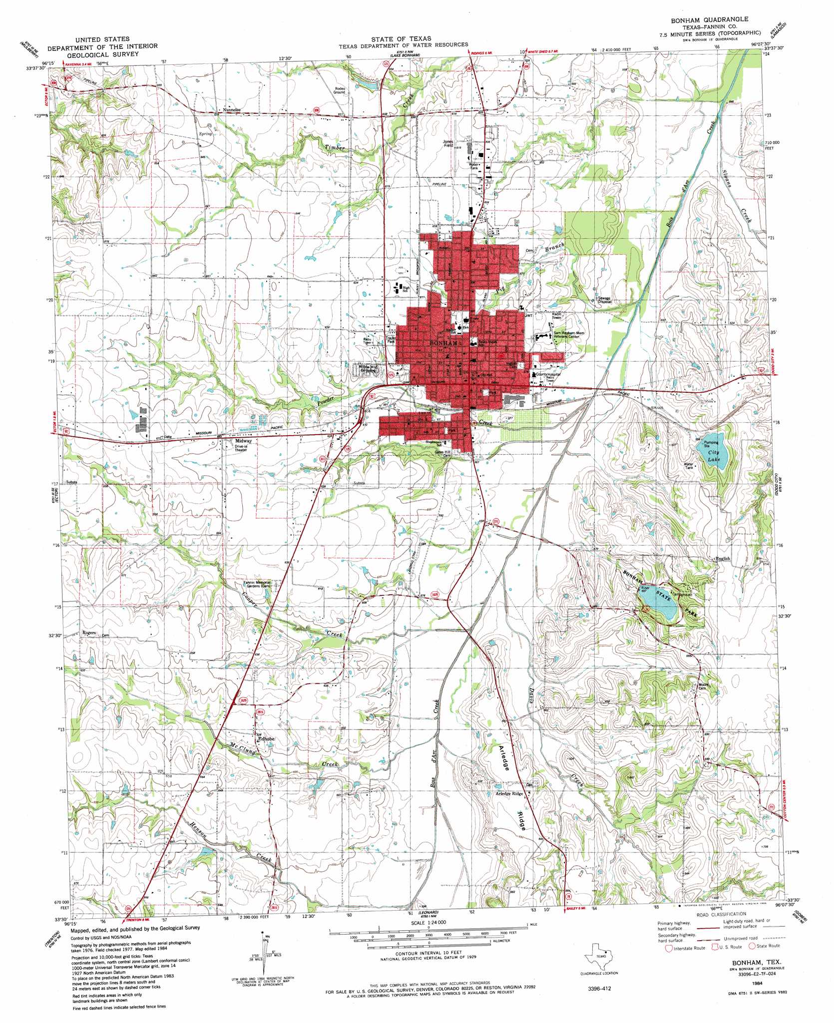
USGS Topo Quad 33096e2 - 1:24,000 scale
| Topo Map Name: | Bonham |
| USGS Topo Quad ID: | 33096e2 |
| Print Size: | ca. 21 1/4" wide x 27" high |
| Southeast Coordinates: | 33.5° N latitude / 96.125° W longitude |
| Map Center Coordinates: | 33.5625° N latitude / 96.1875° W longitude |
| U.S. State: | TX |
| Filename: | o33096e2.jpg |
| Download Map JPG Image: | Bonham topo map 1:24,000 scale |
| Map Type: | Topographic |
| Topo Series: | 7.5´ |
| Map Scale: | 1:24,000 |
| Source of Map Images: | United States Geological Survey (USGS) |
| Alternate Map Versions: |
Bonham TX 1984, updated 1985 Download PDF Buy paper map Bonham TX 2010 Download PDF Buy paper map Bonham TX 2013 Download PDF Buy paper map Bonham TX 2016 Download PDF Buy paper map |
1:24,000 Topo Quads surrounding Bonham
Achille |
Kemp |
Yuba |
Telephone |
Monkstown |
Ambrose |
Mulberry |
Lake Bonham |
Lamasco |
Selfs |
Whitewright |
Ector |
Bonham |
Dodd City |
Honey Grove |
Pilot Grove |
Trenton |
Leonard |
Gober |
Ladonia |
Blue Ridge |
Pike |
Celeste |
Wolfe City |
Commerce North |
> Back to 33096e1 at 1:100,000 scale
> Back to 33096a1 at 1:250,000 scale
> Back to U.S. Topo Maps home
Bonham topo map: Gazetteer
Bonham: Airports
Jones Field elevation 187m 613′R V Ranch Airport elevation 179m 587′
Bonham: Dams
Bonham State Park Dam elevation 181m 593′City Dam elevation 179m 587′
Bonham: Parks
Bonham State Park elevation 186m 610′Bonham State Park elevation 186m 610′
City of Bonham Softball Complex elevation 189m 620′
Warrior Stadium elevation 188m 616′
Bonham: Populated Places
Bonham elevation 186m 610′Edhube elevation 190m 623′
English elevation 198m 649′
Midway elevation 198m 649′
Nunnelee elevation 196m 643′
Rogers elevation 205m 672′
Bonham: Reservoirs
Bonham State Park Lake elevation 181m 593′City Lake elevation 178m 583′
Bonham: Streams
Cooper Creek elevation 168m 551′Davis Creek elevation 168m 551′
Freeman Creek elevation 174m 570′
Henson Creek elevation 174m 570′
McClung Creek elevation 171m 561′
Pig Branch elevation 164m 538′
Powder Creek elevation 168m 551′
Sloans Creek elevation 161m 528′
Bonham: Trails
Bonham State Park Trail elevation 186m 610′Bonham digital topo map on disk
Buy this Bonham topo map showing relief, roads, GPS coordinates and other geographical features, as a high-resolution digital map file on DVD: