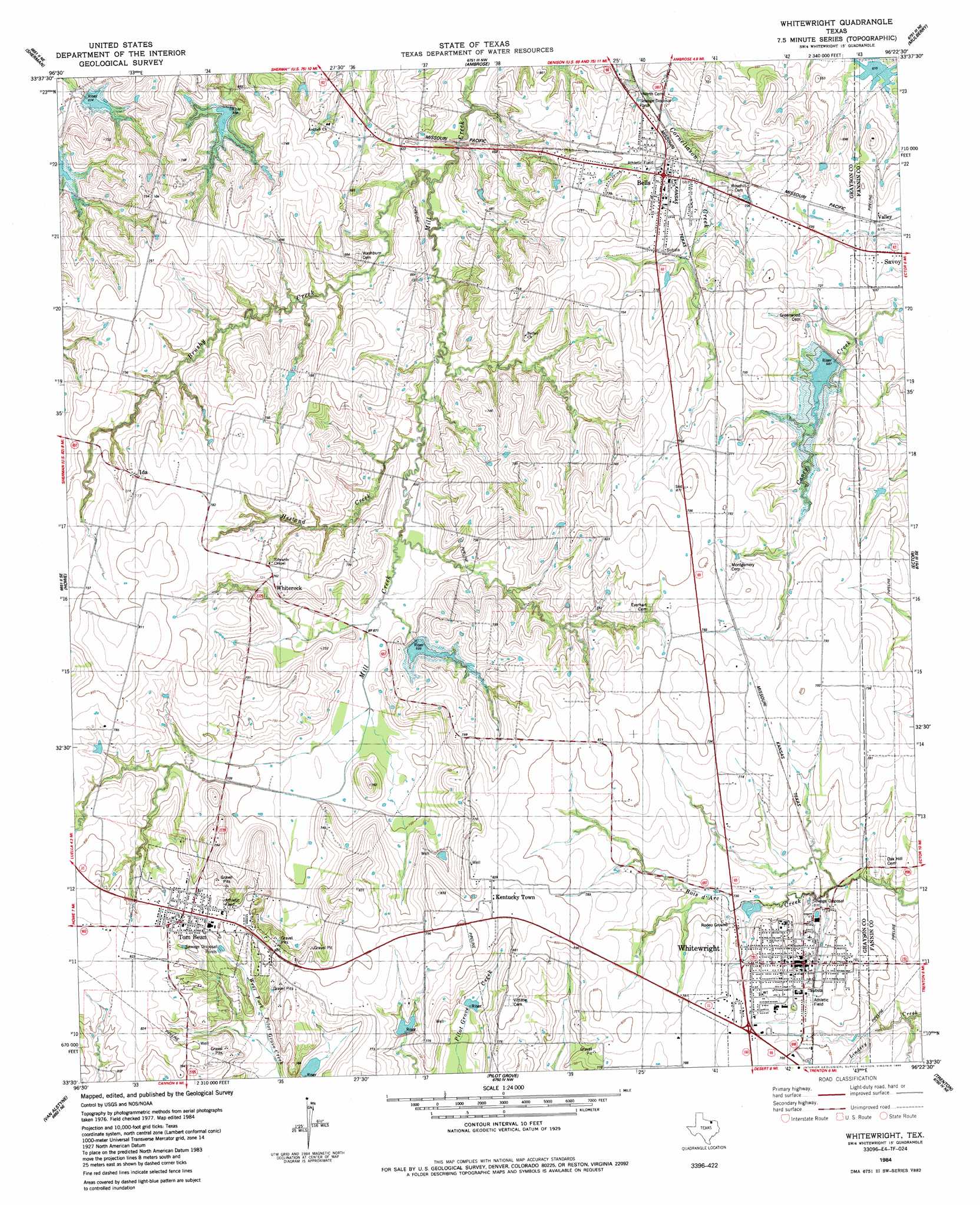
Whitewright Topo Map Texas
To zoom in, hover over the map of Whitewright
USGS Topo Quad 33096e4 - 1:24,000 scale
| Topo Map Name: | Whitewright |
| USGS Topo Quad ID: | 33096e4 |
| Print Size: | ca. 21 1/4" wide x 27" high |
| Southeast Coordinates: | 33.5° N latitude / 96.375° W longitude |
| Map Center Coordinates: | 33.5625° N latitude / 96.4375° W longitude |
| U.S. State: | TX |
| Filename: | o33096e4.jpg |
| Download Map JPG Image: | Whitewright topo map 1:24,000 scale |
| Map Type: | Topographic |
| Topo Series: | 7.5´ |
| Map Scale: | 1:24,000 |
| Source of Map Images: | United States Geological Survey (USGS) |
| Alternate Map Versions: |
Whitewright TX 1984, updated 1985 Download PDF Buy paper map Whitewright TX 2010 Download PDF Buy paper map Whitewright TX 2013 Download PDF Buy paper map Whitewright TX 2016 Download PDF Buy paper map |
1:24,000 Topo Quads surrounding Whitewright
Pottsboro |
Denison Dam |
Achille |
Kemp |
Yuba |
Sherman Nw |
Sherman |
Ambrose |
Mulberry |
Lake Bonham |
Dorchester |
Howe |
Whitewright |
Ector |
Bonham |
Gunter |
Van Alstyne |
Pilot Grove |
Trenton |
Leonard |
Weston |
Anna |
Blue Ridge |
Pike |
Celeste |
> Back to 33096e1 at 1:100,000 scale
> Back to 33096a1 at 1:250,000 scale
> Back to U.S. Topo Maps home
Whitewright topo map: Gazetteer
Whitewright: Dams
Soil Conservation Service Site 1 Dam elevation 205m 672′Soil Conservation Service Site 23 Dam elevation 195m 639′
Soil Conservation Service Site 26 Dam elevation 216m 708′
Soil Conservation Service Site 27 Dam elevation 215m 705′
Soil Conservation Service Site 29 Dam elevation 204m 669′
Soil Conservation Service Site 3 Dam elevation 223m 731′
Soil Conservation Service Site 4a Dam elevation 225m 738′
Soil Conservation Service Site 4b Dam elevation 228m 748′
Trail Lake Dam elevation 184m 603′
Whitewright: Populated Places
Bells elevation 210m 688′Canaan elevation 236m 774′
Ida elevation 235m 770′
Kentucky Town elevation 251m 823′
Tom Bean elevation 250m 820′
Whiterock elevation 231m 757′
Whitewright elevation 229m 751′
Whitewright: Reservoirs
Soil Conservation Service Site 1 Reservoir elevation 205m 672′Soil Conservation Service Site 23 Reservoir elevation 195m 639′
Soil Conservation Service Site 26 Reservoir elevation 216m 708′
Soil Conservation Service Site 27 Reservoir elevation 215m 705′
Soil Conservation Service Site 29 Reservoir elevation 204m 669′
Soil Conservation Service Site 3 Reservoir elevation 223m 731′
Soil Conservation Service Site 4a Reservoir elevation 225m 738′
Soil Conservation Service Site 4b Reservoir elevation 228m 748′
Trail Lake elevation 184m 603′
Whitewright: Streams
Brushy Creek elevation 182m 597′Hestand Creek elevation 192m 629′
Whitewright digital topo map on disk
Buy this Whitewright topo map showing relief, roads, GPS coordinates and other geographical features, as a high-resolution digital map file on DVD: