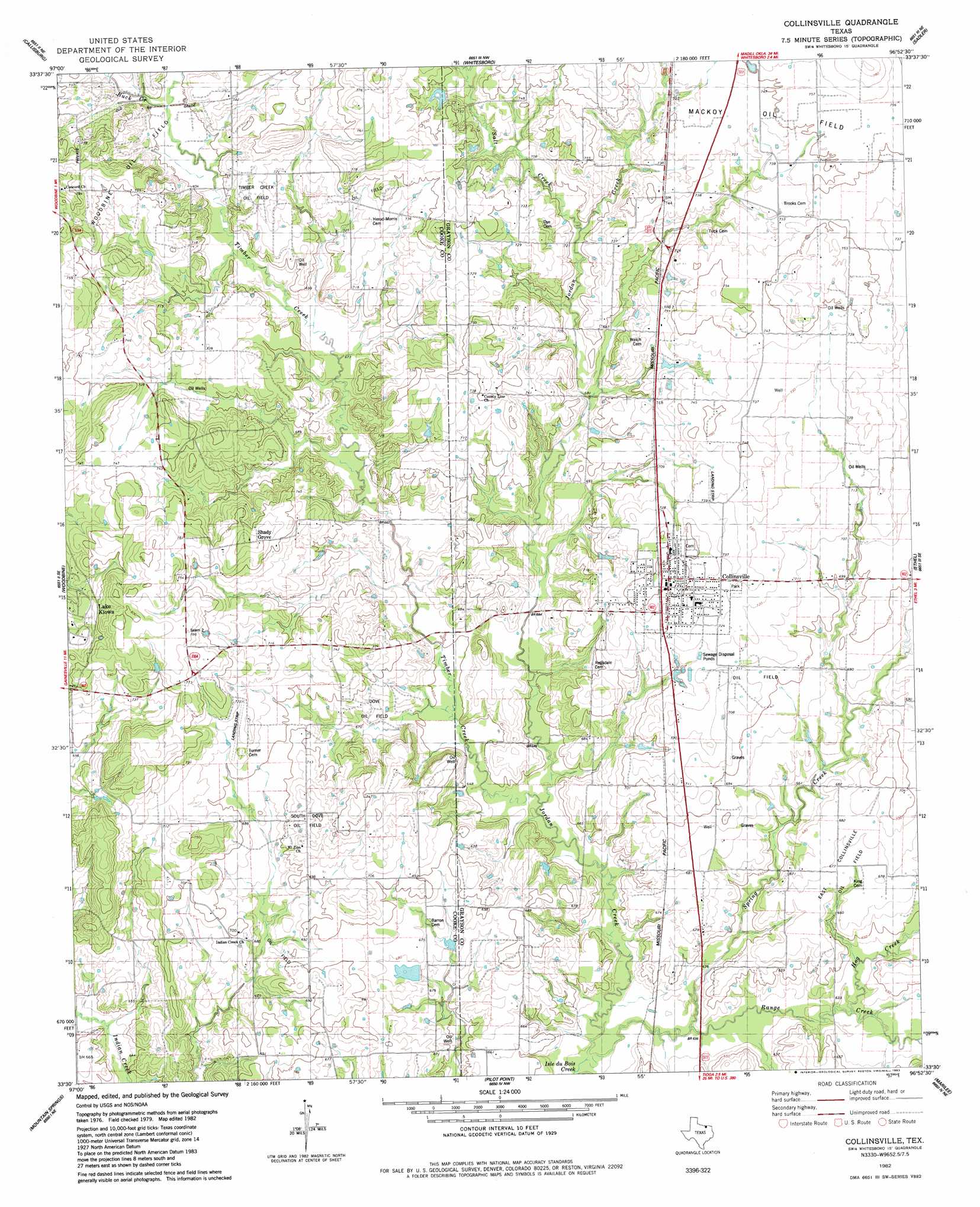
Collinsville Topo Map Texas
To zoom in, hover over the map of Collinsville
USGS Topo Quad 33096e8 - 1:24,000 scale
| Topo Map Name: | Collinsville |
| USGS Topo Quad ID: | 33096e8 |
| Print Size: | ca. 21 1/4" wide x 27" high |
| Southeast Coordinates: | 33.5° N latitude / 96.875° W longitude |
| Map Center Coordinates: | 33.5625° N latitude / 96.9375° W longitude |
| U.S. State: | TX |
| Filename: | o33096e8.jpg |
| Download Map JPG Image: | Collinsville topo map 1:24,000 scale |
| Map Type: | Topographic |
| Topo Series: | 7.5´ |
| Map Scale: | 1:24,000 |
| Source of Map Images: | United States Geological Survey (USGS) |
| Alternate Map Versions: |
Collinsville TX 1982, updated 1983 Download PDF Buy paper map Collinsville TX 2010 Download PDF Buy paper map Collinsville TX 2013 Download PDF Buy paper map Collinsville TX 2016 Download PDF Buy paper map |
1:24,000 Topo Quads surrounding Collinsville
Thackerville |
Horseshoe Bend |
Dexter |
Gordonville |
Pottsboro |
Gainesville North |
Callisburg |
Whitesboro |
Sadler |
Sherman Nw |
Gainesville South |
Woodbine |
Collinsville |
Ethel |
Dorchester |
Valley View |
Mountain Springs |
Pilot Point |
Marilee |
Gunter |
Sanger |
Green Valley |
Aubrey |
Celina |
Weston |
> Back to 33096e1 at 1:100,000 scale
> Back to 33096a1 at 1:250,000 scale
> Back to U.S. Topo Maps home
Collinsville topo map: Gazetteer
Collinsville: Airports
Hayesport Airport elevation 219m 718′Sudden Stop Airport elevation 223m 731′
Collinsville: Oilfields
Collinsville Oil Field elevation 208m 682′Dawkins Oil Field elevation 224m 734′
Dove Oil Field elevation 211m 692′
Makoy Oil Field elevation 223m 731′
South Dove Oil Field elevation 221m 725′
Timber Creek Oil Field elevation 223m 731′
Underwood Oil Field elevation 228m 748′
Woodbine Oil Field elevation 222m 728′
Collinsville: Populated Places
Collinsville elevation 229m 751′Shady Grove elevation 237m 777′
Collinsville: Streams
Buck Creek elevation 213m 698′Hog Creek elevation 192m 629′
Jordan Creek elevation 189m 620′
Range Creek elevation 189m 620′
Spring Creek elevation 189m 620′
Timber Creek elevation 192m 629′
Collinsville digital topo map on disk
Buy this Collinsville topo map showing relief, roads, GPS coordinates and other geographical features, as a high-resolution digital map file on DVD: