Sherman Topo Map Texas
To zoom in, hover over the map of Sherman
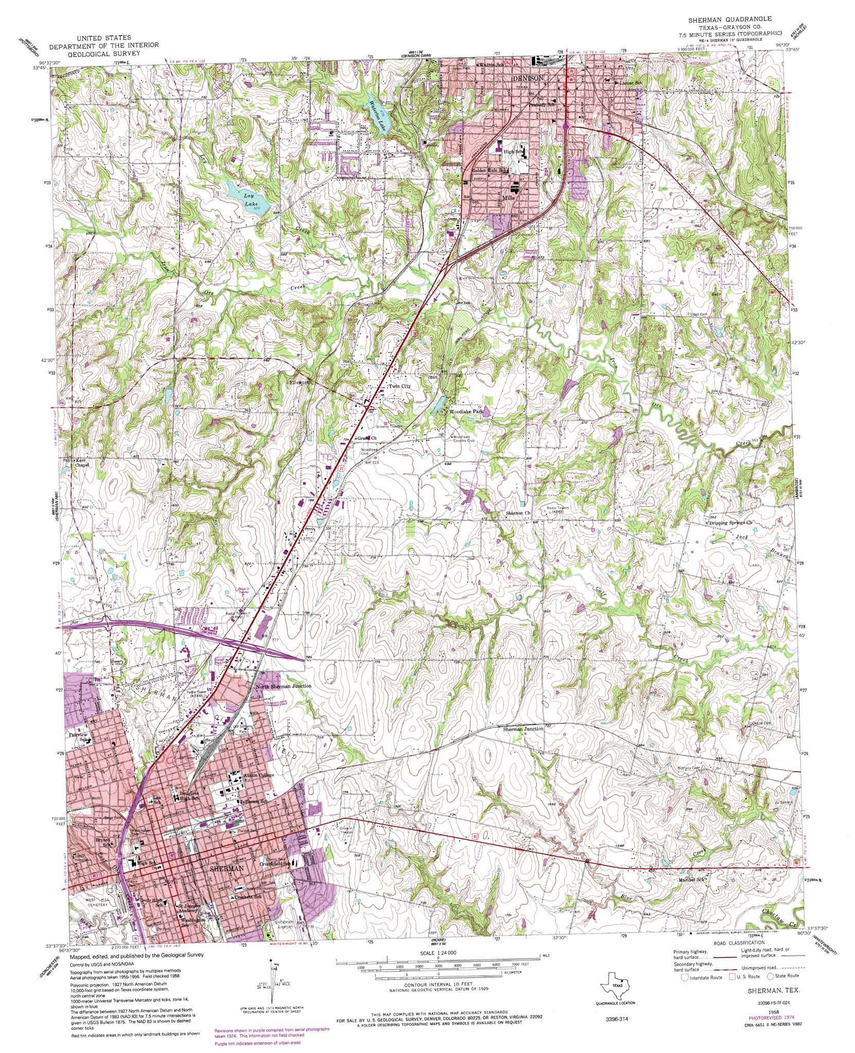
USGS Topo Quad 33096f5 - 1:24,000 scale
| Topo Map Name: | Sherman |
| USGS Topo Quad ID: | 33096f5 |
| Print Size: | ca. 21 1/4" wide x 27" high |
| Southeast Coordinates: | 33.625° N latitude / 96.5° W longitude |
| Map Center Coordinates: | 33.6875° N latitude / 96.5625° W longitude |
| U.S. State: | TX |
| Filename: | o33096f5.jpg |
| Download Map JPG Image: | Sherman topo map 1:24,000 scale |
| Map Type: | Topographic |
| Topo Series: | 7.5´ |
| Map Scale: | 1:24,000 |
| Source of Map Images: | United States Geological Survey (USGS) |
| Alternate Map Versions: |
Sherman TX 1958, updated 1959 Download PDF Buy paper map Sherman TX 1958, updated 1975 Download PDF Buy paper map Sherman TX 1958, updated 1991 Download PDF Buy paper map Sherman TX 2010 Download PDF Buy paper map Sherman TX 2013 Download PDF Buy paper map Sherman TX 2016 Download PDF Buy paper map |
1:24,000 Topo Quads surrounding Sherman
Shay |
Kingston South |
Platter |
Durant South |
Roberta |
Gordonville |
Pottsboro |
Denison Dam |
Achille |
Kemp |
Sadler |
Sherman Nw |
Sherman |
Ambrose |
Mulberry |
Ethel |
Dorchester |
Howe |
Whitewright |
Ector |
Marilee |
Gunter |
Van Alstyne |
Pilot Grove |
Trenton |
> Back to 33096e1 at 1:100,000 scale
> Back to 33096a1 at 1:250,000 scale
> Back to U.S. Topo Maps home
Sherman topo map: Gazetteer
Sherman: Airports
Department of Public Safety Heliport elevation 224m 734′Wilson N Jones Memorial Hospital Heliport elevation 227m 744′
Sherman: Dams
Loy Lake Dam elevation 201m 659′Soil Conservation Service Site 39 Dam elevation 180m 590′
Soil Conservation Service Site 40 Dam elevation 190m 623′
Waterloo Lake Dam elevation 199m 652′
Woodlawn Lake Number 1 Dam elevation 192m 629′
Sherman: Parks
Bearcat Stadium elevation 209m 685′Birge Park elevation 213m 698′
Cherry Park elevation 225m 738′
Eisenhower Birthplace State Historic Site elevation 225m 738′
Ely Park elevation 215m 705′
Fielder Park elevation 232m 761′
Jones Park elevation 240m 787′
Jones Park elevation 239m 784′
Loy Park elevation 205m 672′
Moore Park elevation 212m 695′
Old Settlers Park elevation 241m 790′
Rosedale Park elevation 224m 734′
Washington Park elevation 211m 692′
Waterloo Park elevation 207m 679′
Sherman: Populated Places
Ellsworth elevation 206m 675′Frontier Village elevation 203m 666′
Knollwood elevation 252m 826′
Mills elevation 203m 666′
North Sherman Junction elevation 238m 780′
Sherman elevation 224m 734′
Sherman Junction elevation 222m 728′
Twin City elevation 221m 725′
Woodlake Park elevation 210m 688′
Sherman: Reservoirs
Loy Lake elevation 202m 662′Soil Conservation Service Site 39 Reservoir elevation 180m 590′
Soil Conservation Service Site 40 Reservoir elevation 190m 623′
Waterloo Lake elevation 204m 669′
Woodlawn Lake Number 1 elevation 192m 629′
Sherman: Springs
Dripping Springs elevation 192m 629′Sherman: Streams
Loy Creek elevation 187m 613′Sherman digital topo map on disk
Buy this Sherman topo map showing relief, roads, GPS coordinates and other geographical features, as a high-resolution digital map file on DVD: