Pottsboro Topo Map Texas
To zoom in, hover over the map of Pottsboro
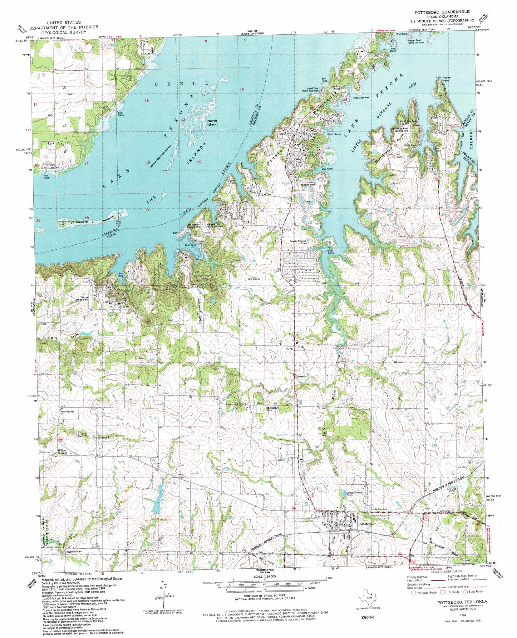
USGS Topo Quad 33096g6 - 1:24,000 scale
| Topo Map Name: | Pottsboro |
| USGS Topo Quad ID: | 33096g6 |
| Print Size: | ca. 21 1/4" wide x 27" high |
| Southeast Coordinates: | 33.75° N latitude / 96.625° W longitude |
| Map Center Coordinates: | 33.8125° N latitude / 96.6875° W longitude |
| U.S. States: | TX, OK |
| Filename: | o33096g6.jpg |
| Download Map JPG Image: | Pottsboro topo map 1:24,000 scale |
| Map Type: | Topographic |
| Topo Series: | 7.5´ |
| Map Scale: | 1:24,000 |
| Source of Map Images: | United States Geological Survey (USGS) |
| Alternate Map Versions: |
Pottsboro TX 1982, updated 1983 Download PDF Buy paper map Pottsboro TX 1982, updated 1983 Download PDF Buy paper map Pottsboro TX 2010 Download PDF Buy paper map Pottsboro TX 2013 Download PDF Buy paper map Pottsboro TX 2016 Download PDF Buy paper map |
1:24,000 Topo Quads surrounding Pottsboro
Mcmillan |
Madill |
Kingston North |
Little City |
Durant North |
Lebanon |
Shay |
Kingston South |
Platter |
Durant South |
Dexter |
Gordonville |
Pottsboro |
Denison Dam |
Achille |
Whitesboro |
Sadler |
Sherman Nw |
Sherman |
Ambrose |
Collinsville |
Ethel |
Dorchester |
Howe |
Whitewright |
> Back to 33096e1 at 1:100,000 scale
> Back to 33096a1 at 1:250,000 scale
> Back to U.S. Topo Maps home
Pottsboro topo map: Gazetteer
Pottsboro: Airports
Grandpappy Point Landing Strip elevation 217m 711′Hitex Airport elevation 211m 692′
Loes Highport Landing Strip elevation 205m 672′
Tanglewood Airfield elevation 241m 790′
Texoma Landing Field elevation 233m 764′
Pottsboro: Bays
Little Mineral Arm elevation 188m 616′Pottsboro: Capes
Grandpappy Point elevation 198m 649′Preston Peninsula elevation 214m 702′
Rocky Point elevation 207m 679′
Pottsboro: Dams
Russell Dam elevation 213m 698′Pottsboro: Islands
North Island elevation 188m 616′The Islands elevation 189m 620′
Pottsboro: Parks
Grandpappy Point Park elevation 216m 708′Highport Public Use Area elevation 199m 652′
Island View Park elevation 197m 646′
Island View Public Use Area elevation 204m 669′
Preston Bend Park elevation 199m 652′
Pottsboro: Populated Places
Cambridge elevation 233m 764′Fink elevation 212m 695′
Pottsboro elevation 232m 761′
Willow Spring elevation 215m 705′
Pottsboro: Reservoirs
Russell Lake elevation 213m 698′Pottsboro: Streams
Little Mineral Creek elevation 188m 616′Pottsboro digital topo map on disk
Buy this Pottsboro topo map showing relief, roads, GPS coordinates and other geographical features, as a high-resolution digital map file on DVD: