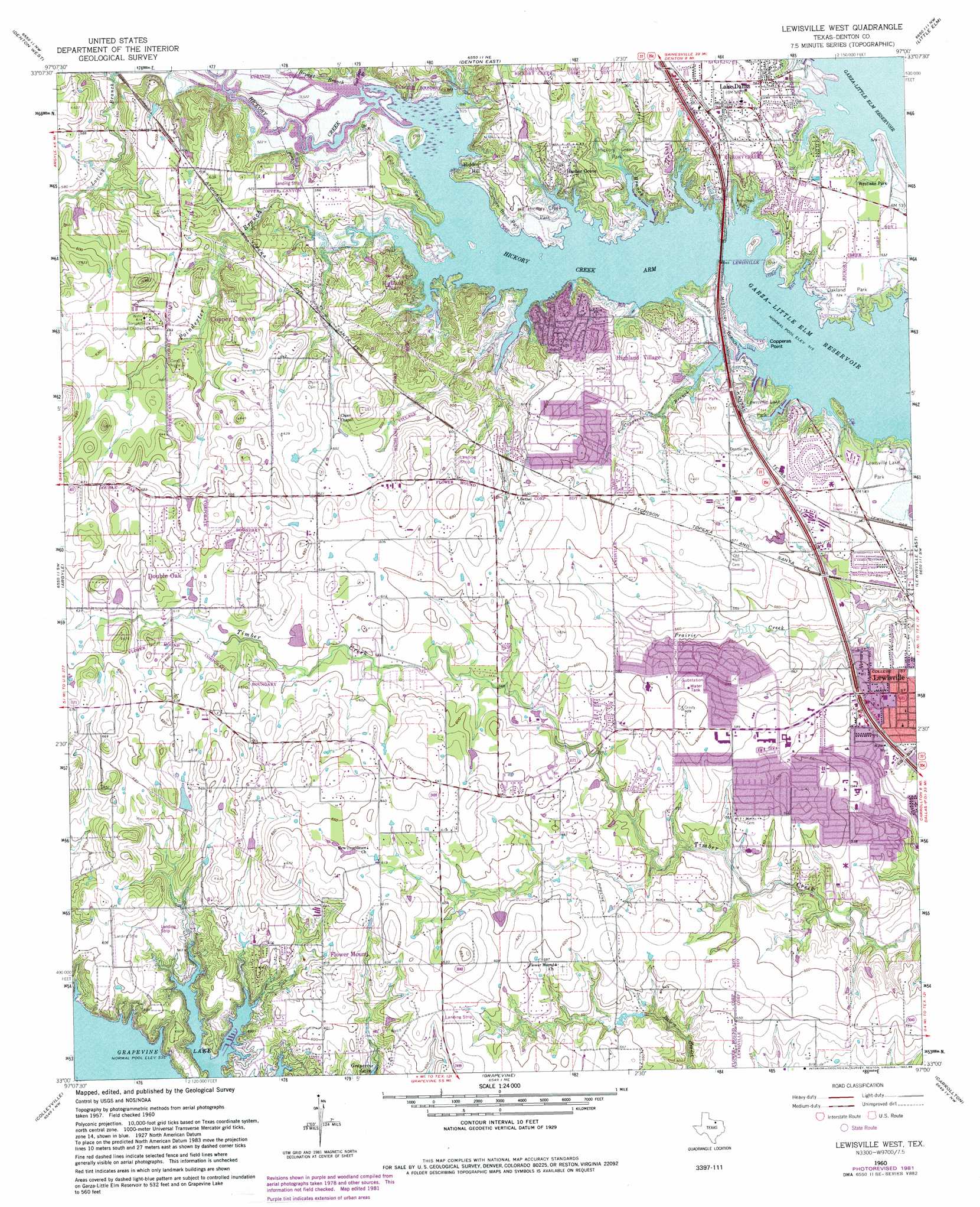
Lewisville West Topo Map Texas
To zoom in, hover over the map of Lewisville West
USGS Topo Quad 33097a1 - 1:24,000 scale
| Topo Map Name: | Lewisville West |
| USGS Topo Quad ID: | 33097a1 |
| Print Size: | ca. 21 1/4" wide x 27" high |
| Southeast Coordinates: | 33° N latitude / 97° W longitude |
| Map Center Coordinates: | 33.0625° N latitude / 97.0625° W longitude |
| U.S. State: | TX |
| Filename: | o33097a1.jpg |
| Download Map JPG Image: | Lewisville West topo map 1:24,000 scale |
| Map Type: | Topographic |
| Topo Series: | 7.5´ |
| Map Scale: | 1:24,000 |
| Source of Map Images: | United States Geological Survey (USGS) |
| Alternate Map Versions: |
Lewisville West TX 1960, updated 1962 Download PDF Buy paper map Lewisville West TX 1960, updated 1967 Download PDF Buy paper map Lewisville West TX 1960, updated 1969 Download PDF Buy paper map Lewisville West TX 1960, updated 1974 Download PDF Buy paper map Lewisville West TX 1960, updated 1982 Download PDF Buy paper map Lewisville West TX 1960, updated 1986 Download PDF Buy paper map Lewisville West TX 2010 Download PDF Buy paper map Lewisville West TX 2013 Download PDF Buy paper map Lewisville West TX 2016 Download PDF Buy paper map |
1:24,000 Topo Quads surrounding Lewisville West
Era Se |
Sanger |
Green Valley |
Aubrey |
Celina |
Ponder |
Denton West |
Denton East |
Little Elm |
Frisco |
Justin |
Argyle |
Lewisville West |
Lewisville East |
Hebron |
Keller |
Colleyville |
Grapevine |
Carrollton |
Addison |
Haltom City |
Hurst |
Euless |
Irving |
Dallas |
> Back to 33097a1 at 1:100,000 scale
> Back to 33096a1 at 1:250,000 scale
> Back to U.S. Topo Maps home
Lewisville West topo map: Gazetteer
Lewisville West: Airports
Black Mark Strip elevation 194m 636′Culwell Ranch Airport elevation 189m 620′
Flower Mound Airport elevation 192m 629′
Hilliard Landing Area elevation 192m 629′
Shiloh Airport elevation 190m 623′
Windmill Hill Airport elevation 186m 610′
Lewisville West: Bays
Hickory Creek Arm elevation 157m 515′Lewisville West: Capes
Copperas Point elevation 157m 515′Lewisville West: Crossings
Interchange 451 elevation 168m 551′Interchange 452 elevation 170m 557′
Lewisville West: Dams
Triple R Ranch Lake Dam elevation 186m 610′Lewisville West: Parks
College Park elevation 155m 508′Copperas Branch Park elevation 162m 531′
Hickory Creek Park elevation 168m 551′
Lake Dallas Stadium elevation 174m 570′
Lewisville Lake Park elevation 165m 541′
Max Goldsmith Stadium elevation 170m 557′
Oakland Park elevation 163m 534′
Pilot Knolls Park elevation 158m 518′
Sycamore Bend Park elevation 162m 531′
West Lake Park elevation 160m 524′
Willow Park Grove elevation 159m 521′
Woods Park elevation 172m 564′
Lewisville West: Populated Places
Copper Canyon elevation 190m 623′Double Oak elevation 201m 659′
Flower Mound elevation 184m 603′
Harbor Grove elevation 173m 567′
Hickory Creek elevation 176m 577′
Hidden Hill elevation 171m 561′
Highland Village elevation 169m 554′
Lake Dallas elevation 175m 574′
Lewisville West: Post Offices
Lewisville Post Office elevation 171m 561′Lewisville West: Reservoirs
Triple R Ranch Lake elevation 186m 610′Lewisville West: Streams
Bryant Branch elevation 157m 515′Carter Branch elevation 157m 515′
Copperas Branch elevation 157m 515′
Hickory Creek elevation 157m 515′
Poindexter Branch elevation 157m 515′
Veal Springs Branch elevation 157m 515′
Lewisville West: Trails
Bluestem Nature Trail elevation 169m 554′Central Park Trail elevation 152m 498′
Leonard L Woods Park Trail elevation 181m 593′
Memorial Park Trail elevation 165m 541′
Pilot Knoll Trail elevation 163m 534′
Lewisville West digital topo map on disk
Buy this Lewisville West topo map showing relief, roads, GPS coordinates and other geographical features, as a high-resolution digital map file on DVD: