Bridgeport East Topo Map Texas
To zoom in, hover over the map of Bridgeport East
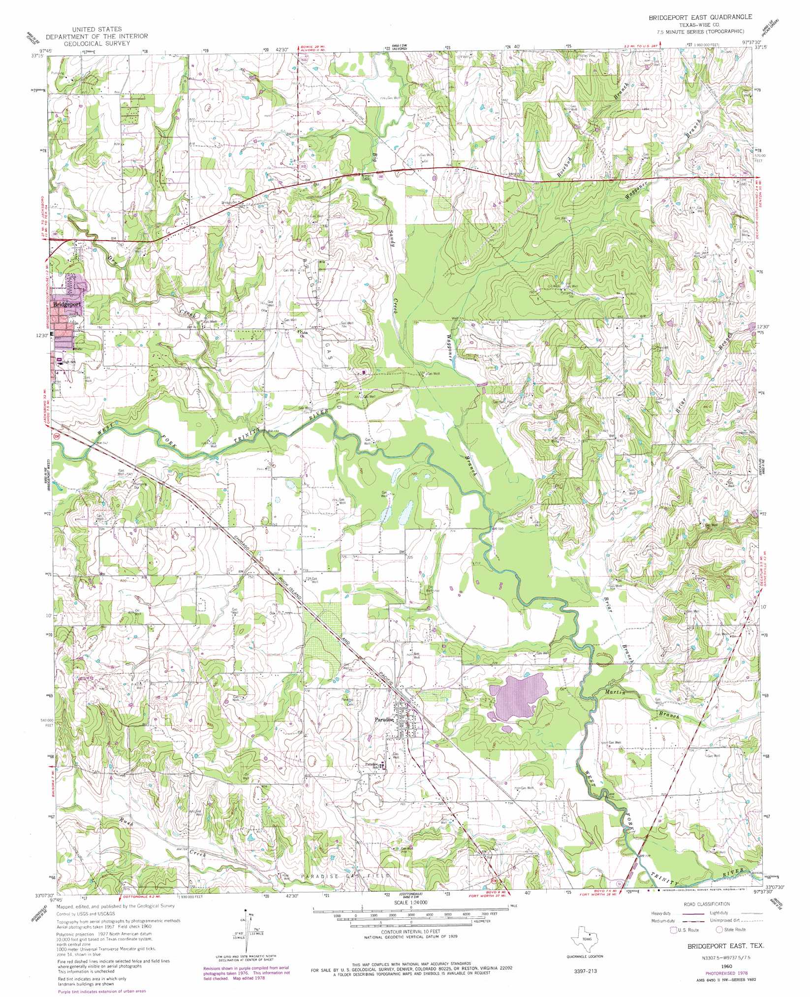
USGS Topo Quad 33097b6 - 1:24,000 scale
| Topo Map Name: | Bridgeport East |
| USGS Topo Quad ID: | 33097b6 |
| Print Size: | ca. 21 1/4" wide x 27" high |
| Southeast Coordinates: | 33.125° N latitude / 97.625° W longitude |
| Map Center Coordinates: | 33.1875° N latitude / 97.6875° W longitude |
| U.S. State: | TX |
| Filename: | o33097b6.jpg |
| Download Map JPG Image: | Bridgeport East topo map 1:24,000 scale |
| Map Type: | Topographic |
| Topo Series: | 7.5´ |
| Map Scale: | 1:24,000 |
| Source of Map Images: | United States Geological Survey (USGS) |
| Alternate Map Versions: |
Bridgeport East TX 1960, updated 1961 Download PDF Buy paper map Bridgeport East TX 1960, updated 1978 Download PDF Buy paper map Bridgeport East TX 2010 Download PDF Buy paper map Bridgeport East TX 2013 Download PDF Buy paper map Bridgeport East TX 2016 Download PDF Buy paper map |
| FStopo: | US Forest Service topo Bridgeport East is available: Download FStopo PDF Download FStopo TIF |
1:24,000 Topo Quads surrounding Bridgeport East
Selma |
Sunset |
Smyrna |
New Harp |
Greenwood |
Crafton |
Chico |
Alvord |
Pecan Creek |
Slidell |
Wizard Wells |
Bridgeport West |
Bridgeport East |
Decatur |
Bluett |
Gibtown |
Boonsville |
Cottondale |
Boyd |
Rhome |
Adell |
Poolville |
Springtown |
Azle |
Avondale |
> Back to 33097a1 at 1:100,000 scale
> Back to 33096a1 at 1:250,000 scale
> Back to U.S. Topo Maps home
Bridgeport East topo map: Gazetteer
Bridgeport East: Airports
Jackson/Bill/ Airport elevation 241m 790′Bridgeport East: Oilfields
Bridgeport Gas Field elevation 243m 797′Bridgeport East: Populated Places
Paradise elevation 231m 757′Bridgeport East: Streams
Big Sandy Creek elevation 219m 718′Briar Branch elevation 213m 698′
Dry Creek elevation 216m 708′
Martin Branch elevation 215m 705′
Rosebud Branch elevation 226m 741′
Waggoner Branch elevation 215m 705′
Watson Branch elevation 224m 734′
Bridgeport East digital topo map on disk
Buy this Bridgeport East topo map showing relief, roads, GPS coordinates and other geographical features, as a high-resolution digital map file on DVD: