Pecan Creek Topo Map Texas
To zoom in, hover over the map of Pecan Creek
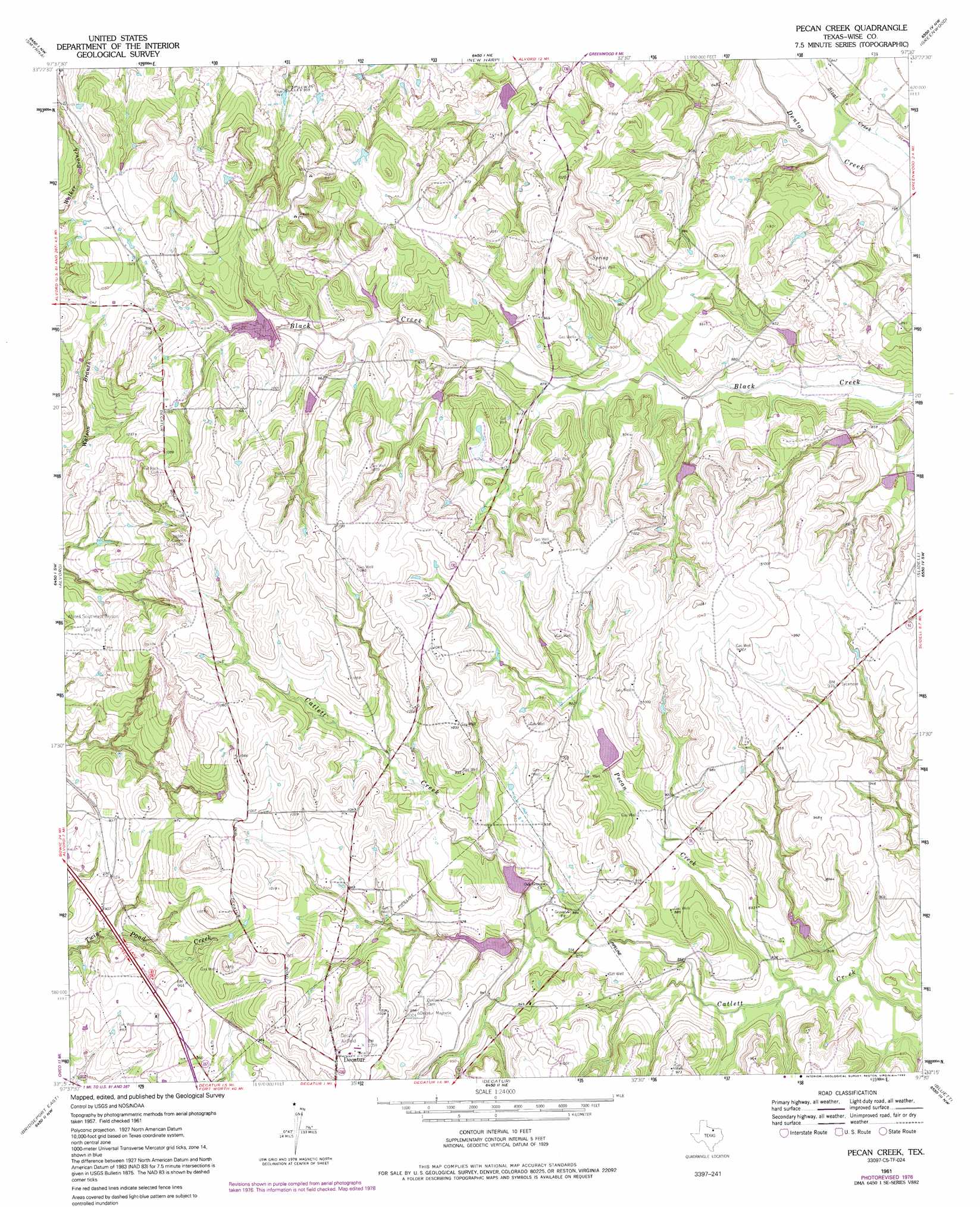
USGS Topo Quad 33097c5 - 1:24,000 scale
| Topo Map Name: | Pecan Creek |
| USGS Topo Quad ID: | 33097c5 |
| Print Size: | ca. 21 1/4" wide x 27" high |
| Southeast Coordinates: | 33.25° N latitude / 97.5° W longitude |
| Map Center Coordinates: | 33.3125° N latitude / 97.5625° W longitude |
| U.S. State: | TX |
| Filename: | o33097c5.jpg |
| Download Map JPG Image: | Pecan Creek topo map 1:24,000 scale |
| Map Type: | Topographic |
| Topo Series: | 7.5´ |
| Map Scale: | 1:24,000 |
| Source of Map Images: | United States Geological Survey (USGS) |
| Alternate Map Versions: |
Pecan Creek TX 1961, updated 1963 Download PDF Buy paper map Pecan Creek TX 1961, updated 1974 Download PDF Buy paper map Pecan Creek TX 1961, updated 1978 Download PDF Buy paper map Pecan Creek TX 1961, updated 1992 Download PDF Buy paper map Pecan Creek TX 2010 Download PDF Buy paper map Pecan Creek TX 2013 Download PDF Buy paper map Pecan Creek TX 2016 Download PDF Buy paper map |
| FStopo: | US Forest Service topo Pecan Creek is available: Download FStopo PDF Download FStopo TIF |
1:24,000 Topo Quads surrounding Pecan Creek
Bowie |
Salona |
Forestburg |
Freemound |
Hood |
Sunset |
Smyrna |
New Harp |
Greenwood |
Era |
Chico |
Alvord |
Pecan Creek |
Slidell |
Era Se |
Bridgeport West |
Bridgeport East |
Decatur |
Bluett |
Ponder |
Boonsville |
Cottondale |
Boyd |
Rhome |
Justin |
> Back to 33097a1 at 1:100,000 scale
> Back to 33096a1 at 1:250,000 scale
> Back to U.S. Topo Maps home
Pecan Creek topo map: Gazetteer
Pecan Creek: Airports
Decatur Municipal Airport elevation 318m 1043′Lazy 9 Ranch Airport elevation 306m 1003′
Pecan Creek: Dams
Soil Conservation Service Site 12d Dam elevation 270m 885′Soil Conservation Service Site 18a-1 Dam elevation 294m 964′
Soil Conservation Service Site 18b Dam elevation 264m 866′
Soil Conservation Service Site 18c Dam elevation 268m 879′
Soil Conservation Service Site 18d Dam elevation 255m 836′
Soil Conservation Service Site 18f Dam elevation 282m 925′
Soil Conservation Service Site 18g Dam elevation 280m 918′
Soil Conservation Service Site 18h Dam elevation 299m 980′
Soil Conservation Service Site 18i Dam elevation 279m 915′
Soil Conservation Service Site 18j Dam elevation 266m 872′
Soil Conservation Service Site 23a Dam elevation 270m 885′
Soil Conservation Service Site 23b Dam elevation 275m 902′
Soil Conservation Service Site 23d Dam elevation 274m 898′
Soil Conservation Service Site 23e Dam elevation 255m 836′
Pecan Creek: Reservoirs
Black Creek Reservoir elevation 294m 964′Soil Conservation Service Site 12d Reservoir elevation 270m 885′
Soil Conservation Service Site 18b Reservoir elevation 264m 866′
Soil Conservation Service Site 18c Reservoir elevation 268m 879′
Soil Conservation Service Site 18d Reservoir elevation 255m 836′
Soil Conservation Service Site 18f Reservoir elevation 282m 925′
Soil Conservation Service Site 18g Reservoir elevation 280m 918′
Soil Conservation Service Site 18h Reservoir elevation 299m 980′
Soil Conservation Service Site 18i Reservoir elevation 279m 915′
Soil Conservation Service Site 18j Reservoir elevation 266m 872′
Soil Conservation Service Site 23a Reservoir elevation 270m 885′
Soil Conservation Service Site 23b Reservoir elevation 275m 902′
Soil Conservation Service Site 23d Reservoir elevation 274m 898′
Soil Conservation Service Site 23e Reservoir elevation 255m 836′
Pecan Creek: Streams
Pecan Creek elevation 253m 830′Pecan Creek digital topo map on disk
Buy this Pecan Creek topo map showing relief, roads, GPS coordinates and other geographical features, as a high-resolution digital map file on DVD: