Mountain Springs Topo Map Texas
To zoom in, hover over the map of Mountain Springs
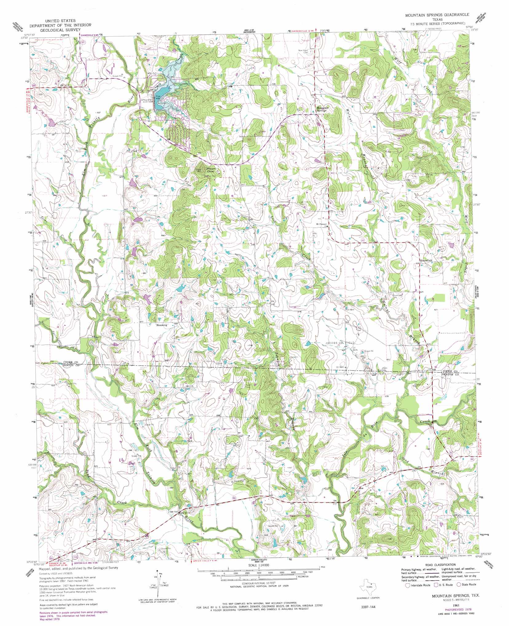
USGS Topo Quad 33097d1 - 1:24,000 scale
| Topo Map Name: | Mountain Springs |
| USGS Topo Quad ID: | 33097d1 |
| Print Size: | ca. 21 1/4" wide x 27" high |
| Southeast Coordinates: | 33.375° N latitude / 97° W longitude |
| Map Center Coordinates: | 33.4375° N latitude / 97.0625° W longitude |
| U.S. State: | TX |
| Filename: | o33097d1.jpg |
| Download Map JPG Image: | Mountain Springs topo map 1:24,000 scale |
| Map Type: | Topographic |
| Topo Series: | 7.5´ |
| Map Scale: | 1:24,000 |
| Source of Map Images: | United States Geological Survey (USGS) |
| Alternate Map Versions: |
Mountain Springs TX 1961, updated 1963 Download PDF Buy paper map Mountain Springs TX 1961, updated 1963 Download PDF Buy paper map Mountain Springs TX 1961, updated 1978 Download PDF Buy paper map Mountain Springs TX 2010 Download PDF Buy paper map Mountain Springs TX 2013 Download PDF Buy paper map Mountain Springs TX 2016 Download PDF Buy paper map |
1:24,000 Topo Quads surrounding Mountain Springs
Muenster East |
Gainesville North |
Callisburg |
Whitesboro |
Sadler |
Hood |
Gainesville South |
Woodbine |
Collinsville |
Ethel |
Era |
Valley View |
Mountain Springs |
Pilot Point |
Marilee |
Era Se |
Sanger |
Green Valley |
Aubrey |
Celina |
Ponder |
Denton West |
Denton East |
Little Elm |
Frisco |
> Back to 33097a1 at 1:100,000 scale
> Back to 33096a1 at 1:250,000 scale
> Back to U.S. Topo Maps home
Mountain Springs topo map: Gazetteer
Mountain Springs: Airports
Belcher Airport elevation 200m 656′Mountain Springs: Dams
Soil Conservation Service Site 18 Dam elevation 200m 656′Soil Conservation Service Site 61t Dam elevation 199m 652′
Soil Conservation Service Site 61u Dam elevation 193m 633′
Soil Conservation Service Site 61v Dam elevation 183m 600′
Soil Conservation Service Site 61w Dam elevation 183m 600′
Soil Conservation Service Site 61x Dam elevation 189m 620′
Tipps Lake Dam elevation 205m 672′
Mountain Springs: Oilfields
Jacobs Oil Field elevation 183m 600′Mountain Springs: Parks
Ray Roberts Lake State Park - Isle Du Bois Unit elevation 213m 698′Ray Roberts Lake State Park - Johnson Branch Unit elevation 201m 659′
Mountain Springs: Populated Places
Bloomfield elevation 194m 636′Hemming elevation 211m 692′
Mountain Springs elevation 217m 711′
Mountain Springs: Reservoirs
Soil Conservation Service Site 61t Reservoir elevation 199m 652′Soil Conservation Service Site 61u Reservoir elevation 193m 633′
Soil Conservation Service Site 61v Reservoir elevation 183m 600′
Soil Conservation Service Site 61w Reservoir elevation 183m 600′
Soil Conservation Service Site 61x Reservoir elevation 189m 620′
Soil Conservation Service Site Number 18 Reservoir elevation 200m 656′
Tipps Lake elevation 205m 672′
Mountain Springs: Springs
Mountain Springs (historical) elevation 207m 679′Mountain Springs: Streams
Johnson Branch elevation 183m 600′Lick Creek elevation 183m 600′
Pecan Creek elevation 183m 600′
Persimmon Creek elevation 183m 600′
Pond Creek elevation 183m 600′
Sand Branch elevation 183m 600′
Spring Creek elevation 183m 600′
Walnut Branch elevation 183m 600′
Mountain Springs: Summits
Mount Olive elevation 255m 836′Mountain Springs: Trails
Elm Fork Greenbelt Trail elevation 206m 675′Jordon Park Trail elevation 203m 666′
Mountain Springs digital topo map on disk
Buy this Mountain Springs topo map showing relief, roads, GPS coordinates and other geographical features, as a high-resolution digital map file on DVD: