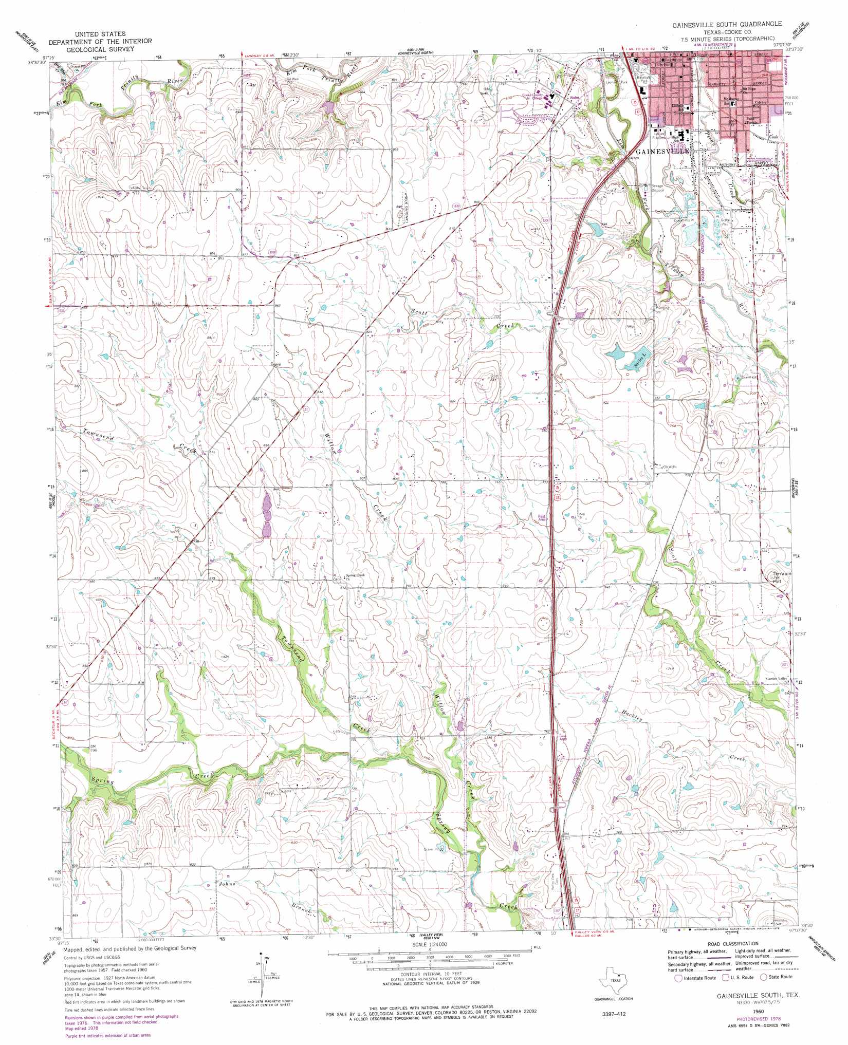
Gainesville South Topo Map Texas
To zoom in, hover over the map of Gainesville South
USGS Topo Quad 33097e2 - 1:24,000 scale
| Topo Map Name: | Gainesville South |
| USGS Topo Quad ID: | 33097e2 |
| Print Size: | ca. 21 1/4" wide x 27" high |
| Southeast Coordinates: | 33.5° N latitude / 97.125° W longitude |
| Map Center Coordinates: | 33.5625° N latitude / 97.1875° W longitude |
| U.S. State: | TX |
| Filename: | o33097e2.jpg |
| Download Map JPG Image: | Gainesville South topo map 1:24,000 scale |
| Map Type: | Topographic |
| Topo Series: | 7.5´ |
| Map Scale: | 1:24,000 |
| Source of Map Images: | United States Geological Survey (USGS) |
| Alternate Map Versions: |
Gainesville South TX 1960, updated 1963 Download PDF Buy paper map Gainesville South TX 1960, updated 1978 Download PDF Buy paper map Gainesville South TX 2010 Download PDF Buy paper map Gainesville South TX 2013 Download PDF Buy paper map Gainesville South TX 2016 Download PDF Buy paper map |
1:24,000 Topo Quads surrounding Gainesville South
Leon South |
Marysville |
Thackerville |
Horseshoe Bend |
Dexter |
Muenster West |
Muenster East |
Gainesville North |
Callisburg |
Whitesboro |
Freemound |
Hood |
Gainesville South |
Woodbine |
Collinsville |
Greenwood |
Era |
Valley View |
Mountain Springs |
Pilot Point |
Slidell |
Era Se |
Sanger |
Green Valley |
Aubrey |
> Back to 33097e1 at 1:100,000 scale
> Back to 33096a1 at 1:250,000 scale
> Back to U.S. Topo Maps home
Gainesville South topo map: Gazetteer
Gainesville South: Airports
Freedom Field elevation 269m 882′Gainesville South: Dams
Sarles Lake Dam elevation 223m 731′Soil Conservation Service Site 61q Dam elevation 241m 790′
Gainesville South: Parks
Leeper Stadium elevation 218m 715′Leonard Park elevation 219m 718′
Leopard Stadium elevation 218m 715′
Gainesville South: Populated Places
Cook elevation 223m 731′Gainesville South: Reservoirs
Sarles Lake elevation 224m 734′Soil Conservation Service Site 61q Reservoir elevation 241m 790′
Gainesville South: Streams
Dry Elm Creek elevation 234m 767′Townsend Creek elevation 216m 708′
Willow Creek elevation 210m 688′
Gainesville South: Summits
Terrapin Hill elevation 232m 761′Gainesville South digital topo map on disk
Buy this Gainesville South topo map showing relief, roads, GPS coordinates and other geographical features, as a high-resolution digital map file on DVD: