Hood Topo Map Texas
To zoom in, hover over the map of Hood
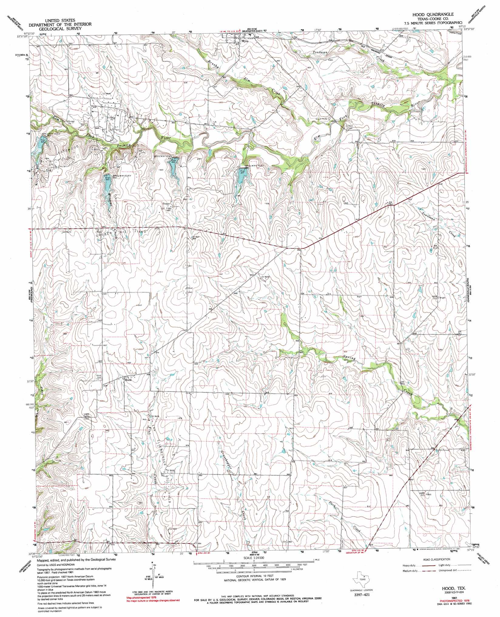
USGS Topo Quad 33097e3 - 1:24,000 scale
| Topo Map Name: | Hood |
| USGS Topo Quad ID: | 33097e3 |
| Print Size: | ca. 21 1/4" wide x 27" high |
| Southeast Coordinates: | 33.5° N latitude / 97.25° W longitude |
| Map Center Coordinates: | 33.5625° N latitude / 97.3125° W longitude |
| U.S. State: | TX |
| Filename: | o33097e3.jpg |
| Download Map JPG Image: | Hood topo map 1:24,000 scale |
| Map Type: | Topographic |
| Topo Series: | 7.5´ |
| Map Scale: | 1:24,000 |
| Source of Map Images: | United States Geological Survey (USGS) |
| Alternate Map Versions: |
Hood TX 1961, updated 1963 Download PDF Buy paper map Hood TX 1961, updated 1991 Download PDF Buy paper map Hood TX 2010 Download PDF Buy paper map Hood TX 2013 Download PDF Buy paper map Hood TX 2016 Download PDF Buy paper map |
1:24,000 Topo Quads surrounding Hood
Bonita |
Leon South |
Marysville |
Thackerville |
Horseshoe Bend |
Saint Jo |
Muenster West |
Muenster East |
Gainesville North |
Callisburg |
Forestburg |
Freemound |
Hood |
Gainesville South |
Woodbine |
New Harp |
Greenwood |
Era |
Valley View |
Mountain Springs |
Pecan Creek |
Slidell |
Era Se |
Sanger |
Green Valley |
> Back to 33097e1 at 1:100,000 scale
> Back to 33096a1 at 1:250,000 scale
> Back to U.S. Topo Maps home
Hood topo map: Gazetteer
Hood: Dams
Soil Conservation Service Site 61k Dam elevation 283m 928′Soil Conservation Service Site 61l Dam elevation 273m 895′
Soil Conservation Service Site 6i Dam elevation 278m 912′
Soil Conservation Service Site 6j2 Dam elevation 284m 931′
Soil Conservation Service Site 6k2 Dam elevation 273m 895′
Soil Conservation Service Site 6l Dam elevation 275m 902′
Hood: Oilfields
Brewer Oil Field elevation 292m 958′Ellenburger Oil Field elevation 289m 948′
Gruber Oil Field elevation 308m 1010′
Hood: Populated Places
Hood elevation 301m 987′Myra elevation 285m 935′
Hood: Reservoirs
Soil Conservation Service Site 61k Reservoir elevation 283m 928′Soil Conservation Service Site 61l Reservoir elevation 273m 895′
Soil Conservation Service Site 6i Reservoir elevation 278m 912′
Soil Conservation Service Site 6j2 Reservoir elevation 284m 931′
Soil Conservation Service Site 6k2 Reservoir elevation 273m 895′
Soil Conservation Service Site 6l Reservoir elevation 275m 902′
Hood: Streams
Brushy Elm Creek elevation 247m 810′Tonkawa Creek elevation 241m 790′
Wildcat Creek elevation 267m 875′
Hood digital topo map on disk
Buy this Hood topo map showing relief, roads, GPS coordinates and other geographical features, as a high-resolution digital map file on DVD: