Salona Topo Map Texas
To zoom in, hover over the map of Salona
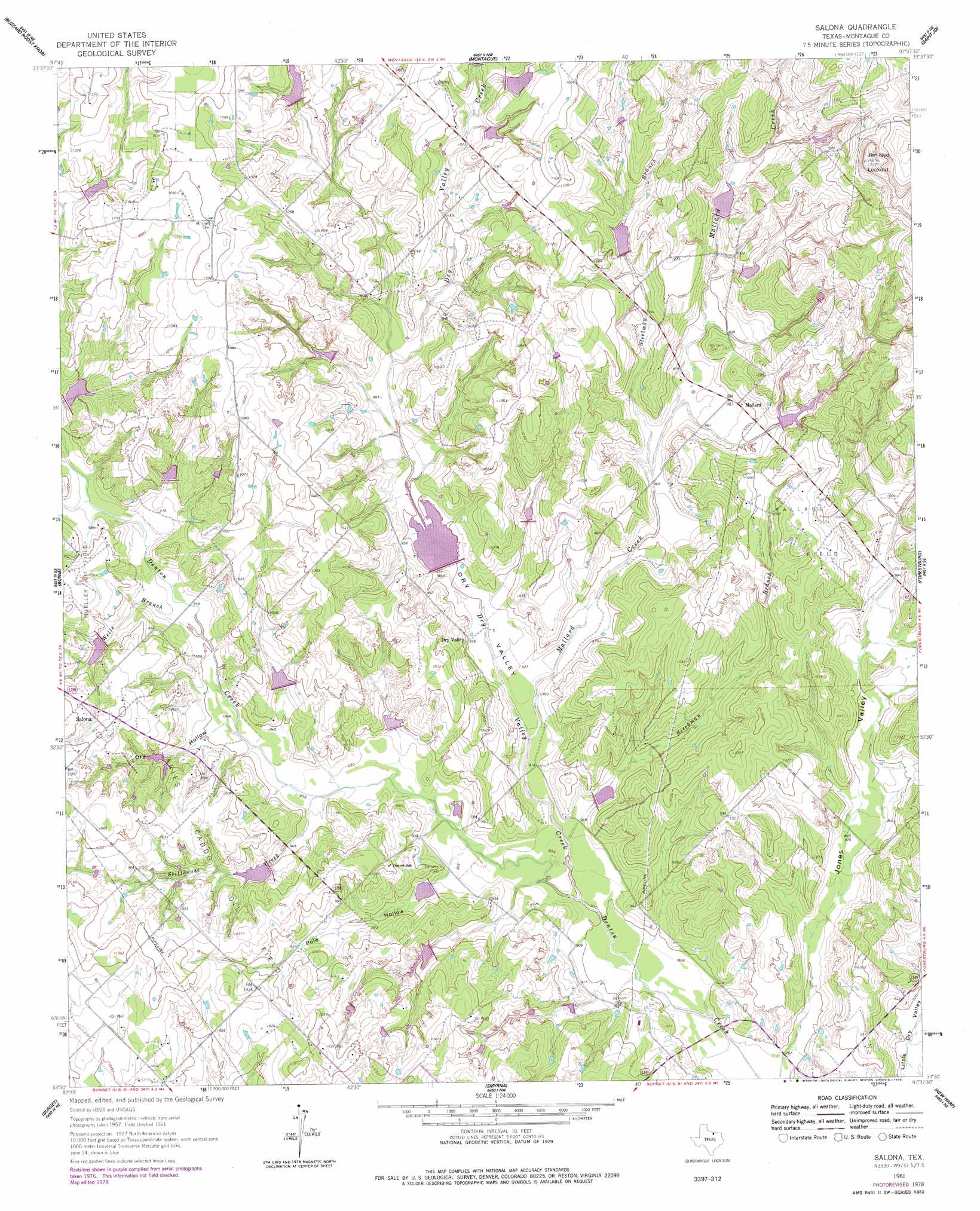
USGS Topo Quad 33097e6 - 1:24,000 scale
| Topo Map Name: | Salona |
| USGS Topo Quad ID: | 33097e6 |
| Print Size: | ca. 21 1/4" wide x 27" high |
| Southeast Coordinates: | 33.5° N latitude / 97.625° W longitude |
| Map Center Coordinates: | 33.5625° N latitude / 97.6875° W longitude |
| U.S. State: | TX |
| Filename: | o33097e6.jpg |
| Download Map JPG Image: | Salona topo map 1:24,000 scale |
| Map Type: | Topographic |
| Topo Series: | 7.5´ |
| Map Scale: | 1:24,000 |
| Source of Map Images: | United States Geological Survey (USGS) |
| Alternate Map Versions: |
Salona TX 1961, updated 1963 Download PDF Buy paper map Salona TX 1961, updated 1978 Download PDF Buy paper map Salona TX 2010 Download PDF Buy paper map Salona TX 2013 Download PDF Buy paper map Salona TX 2016 Download PDF Buy paper map |
1:24,000 Topo Quads surrounding Salona
Ringgold |
Belcherville |
Nocona |
Bonita |
Leon South |
Stoneburg |
Buzzard Roost Knob |
Montague |
Saint Jo |
Muenster West |
Brushy Mound |
Bowie |
Salona |
Forestburg |
Freemound |
Selma |
Sunset |
Smyrna |
New Harp |
Greenwood |
Crafton |
Chico |
Alvord |
Pecan Creek |
Slidell |
> Back to 33097e1 at 1:100,000 scale
> Back to 33096a1 at 1:250,000 scale
> Back to U.S. Topo Maps home
Salona topo map: Gazetteer
Salona: Dams
Soil Conservation Service Land Stabilization Structure 3-7 elevation 320m 1049′Soil Conservation Service Sediment Control Structure 2-9 elevation 306m 1003′
Soil Conservation Service Sediment Control Structure 5-3a elevation 305m 1000′
Soil Conservation Service Sediment Control Structure 8-1 elevation 287m 941′
Soil Conservation Service Site 1b1 Dam elevation 318m 1043′
Soil Conservation Service Site 1e Dam elevation 298m 977′
Soil Conservation Service Site 1j Dam elevation 302m 990′
Soil Conservation Service Site 1k Dam elevation 294m 964′
Soil Conservation Service Site 2a1 Dam elevation 294m 964′
Soil Conservation Service Site 2b Dam elevation 295m 967′
Soil Conservation Service Site 2c Dam elevation 284m 931′
Soil Conservation Service Site 2d Dam elevation 284m 931′
Soil Conservation Service Site 2e1 Dam elevation 314m 1030′
Soil Conservation Service Site 2l Dam elevation 319m 1046′
Soil Conservation Service Site 3 Dam elevation 288m 944′
Soil Conservation Service Site 3a Dam elevation 309m 1013′
Soil Conservation Service Site 3b Dam elevation 313m 1026′
Soil Conservation Service Site 3c Dam elevation 294m 964′
Soil Conservation Service Site 4b Dam elevation 311m 1020′
Soil Conservation Service Site 4c Dam elevation 314m 1030′
Soil Conservation Service Site 5 Dam elevation 282m 925′
Walker Lake Dam elevation 316m 1036′
Salona: Oilfields
Aries Caddo Oil Field elevation 315m 1033′Mallard Oil Field elevation 315m 1033′
Salona: Populated Places
Dry Valley elevation 286m 938′Mallard elevation 301m 987′
Salona elevation 316m 1036′
Salona: Reservoirs
Sediment Control Structure 2-9 Reservoir elevation 306m 1003′Soil Conservation Service Land Stabilization Structure 3-7 Reservoir elevation 320m 1049′
Soil Conservation Service Sediment Control Structure 5-3a Reservoir elevation 305m 1000′
Soil Conservation Service Sediment Control Structure 8-1 Reservoir elevation 287m 941′
Soil Conservation Service Site 1b1 Reservoir elevation 318m 1043′
Soil Conservation Service Site 1e Reservoir elevation 298m 977′
Soil Conservation Service Site 1j Reservoir elevation 302m 990′
Soil Conservation Service Site 1k Reservoir elevation 294m 964′
Soil Conservation Service Site 2a1 Reservoir elevation 294m 964′
Soil Conservation Service Site 2b Reservoir elevation 295m 967′
Soil Conservation Service Site 2c Reservoir elevation 284m 931′
Soil Conservation Service Site 2d Reservoir elevation 284m 931′
Soil Conservation Service Site 2e1 Reservoir elevation 314m 1030′
Soil Conservation Service Site 2l Reservoir elevation 319m 1046′
Soil Conservation Service Site 3 Reservoir elevation 288m 944′
Soil Conservation Service Site 3a Reservoir elevation 309m 1013′
Soil Conservation Service Site 3b Reservoir elevation 313m 1026′
Soil Conservation Service Site 3c Reservoir elevation 294m 964′
Soil Conservation Service Site 4b Reservoir elevation 311m 1020′
Soil Conservation Service Site 4c Reservoir elevation 314m 1030′
Soil Conservation Service Site 5 Reservoir elevation 282m 925′
Walker Lake elevation 316m 1036′
Salona: Streams
Beechman Branch elevation 277m 908′Dry Valley Creek elevation 274m 898′
Mallard Creek elevation 279m 915′
Steelman Branch elevation 292m 958′
Stillhouse Creek elevation 284m 931′
Wells Branch elevation 290m 951′
Salona: Summits
Jim Ned Lookout elevation 394m 1292′Salona: Valleys
Dry Hollow elevation 287m 941′Dry Valley elevation 278m 912′
Jones Valley elevation 271m 889′
Pole Hollow elevation 280m 918′
Salona digital topo map on disk
Buy this Salona topo map showing relief, roads, GPS coordinates and other geographical features, as a high-resolution digital map file on DVD: