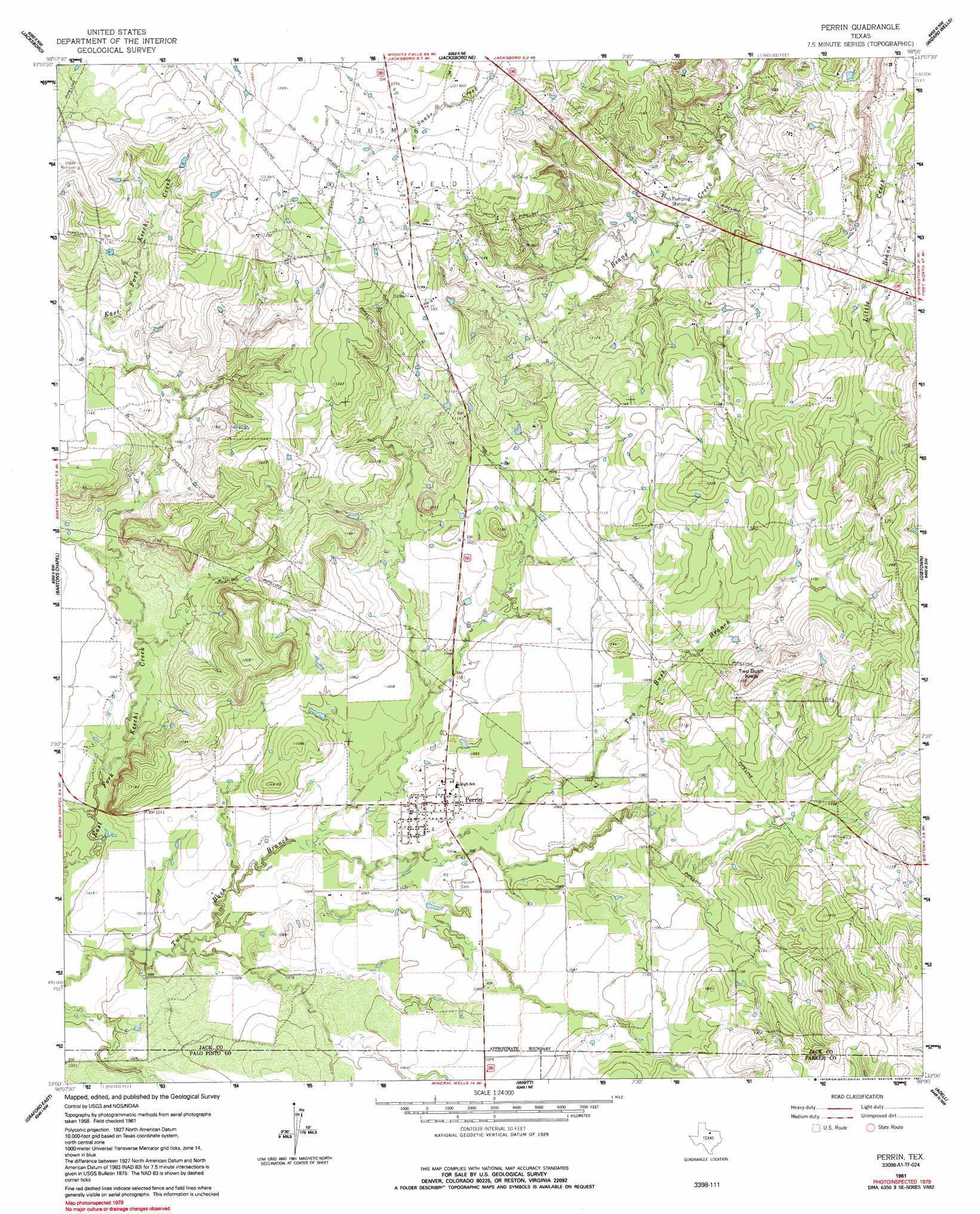
Perrin Topo Map Texas
To zoom in, hover over the map of Perrin
USGS Topo Quad 33098a1 - 1:24,000 scale
| Topo Map Name: | Perrin |
| USGS Topo Quad ID: | 33098a1 |
| Print Size: | ca. 21 1/4" wide x 27" high |
| Southeast Coordinates: | 33° N latitude / 98° W longitude |
| Map Center Coordinates: | 33.0625° N latitude / 98.0625° W longitude |
| U.S. State: | TX |
| Filename: | o33098a1.jpg |
| Download Map JPG Image: | Perrin topo map 1:24,000 scale |
| Map Type: | Topographic |
| Topo Series: | 7.5´ |
| Map Scale: | 1:24,000 |
| Source of Map Images: | United States Geological Survey (USGS) |
| Alternate Map Versions: |
Perrin TX 1961, updated 1962 Download PDF Buy paper map Perrin TX 1961, updated 1991 Download PDF Buy paper map Perrin TX 2010 Download PDF Buy paper map Perrin TX 2012 Download PDF Buy paper map Perrin TX 2016 Download PDF Buy paper map |
1:24,000 Topo Quads surrounding Perrin
Lynn Creek |
Johnson Lake |
Cundiff |
Crafton |
Chico |
Senate |
Jacksboro |
Jacksboro Ne |
Wizard Wells |
Bridgeport West |
Long Hollow |
Bartons Chapel |
Perrin |
Gibtown |
Boonsville |
Graford West |
Graford East |
Whitt |
Adell |
Poolville |
Palo Pinto |
Mineral Wells West |
Mineral Wells East |
Garner |
Weatherford North |
> Back to 33098a1 at 1:100,000 scale
> Back to 33098a1 at 1:250,000 scale
> Back to U.S. Topo Maps home
Perrin topo map: Gazetteer
Perrin: Dams
Soil Conservation Service Site 1 Dam elevation 322m 1056′Soil Conservation Service Site 10 Dam elevation 314m 1030′
Soil Conservation Service Site 3 Dam elevation 319m 1046′
Soil Conservation Service Site 4 Dam elevation 322m 1056′
Soil Conservation Service Site 5 Dam elevation 329m 1079′
Soil Conservation Service Site 6 Dam elevation 332m 1089′
Soil Conservation Service Site 7 Dam elevation 315m 1033′
Soil Conservation Service Site 9 Dam elevation 314m 1030′
Perrin: Populated Places
Perrin elevation 319m 1046′Perrin: Reservoirs
Soil Conservation Service Site 1 Reservoir elevation 322m 1056′Soil Conservation Service Site 10 Reservoir elevation 314m 1030′
Soil Conservation Service Site 3 Reservoir elevation 319m 1046′
Soil Conservation Service Site 4 Reservoir elevation 322m 1056′
Soil Conservation Service Site 5 Reservoir elevation 329m 1079′
Soil Conservation Service Site 6 Reservoir elevation 332m 1089′
Soil Conservation Service Site 7 Reservoir elevation 315m 1033′
Soil Conservation Service Site 9 Reservoir elevation 314m 1030′
Perrin: Summits
Two Bush Knob elevation 373m 1223′Perrin digital topo map on disk
Buy this Perrin topo map showing relief, roads, GPS coordinates and other geographical features, as a high-resolution digital map file on DVD: