Senate Topo Map Texas
To zoom in, hover over the map of Senate
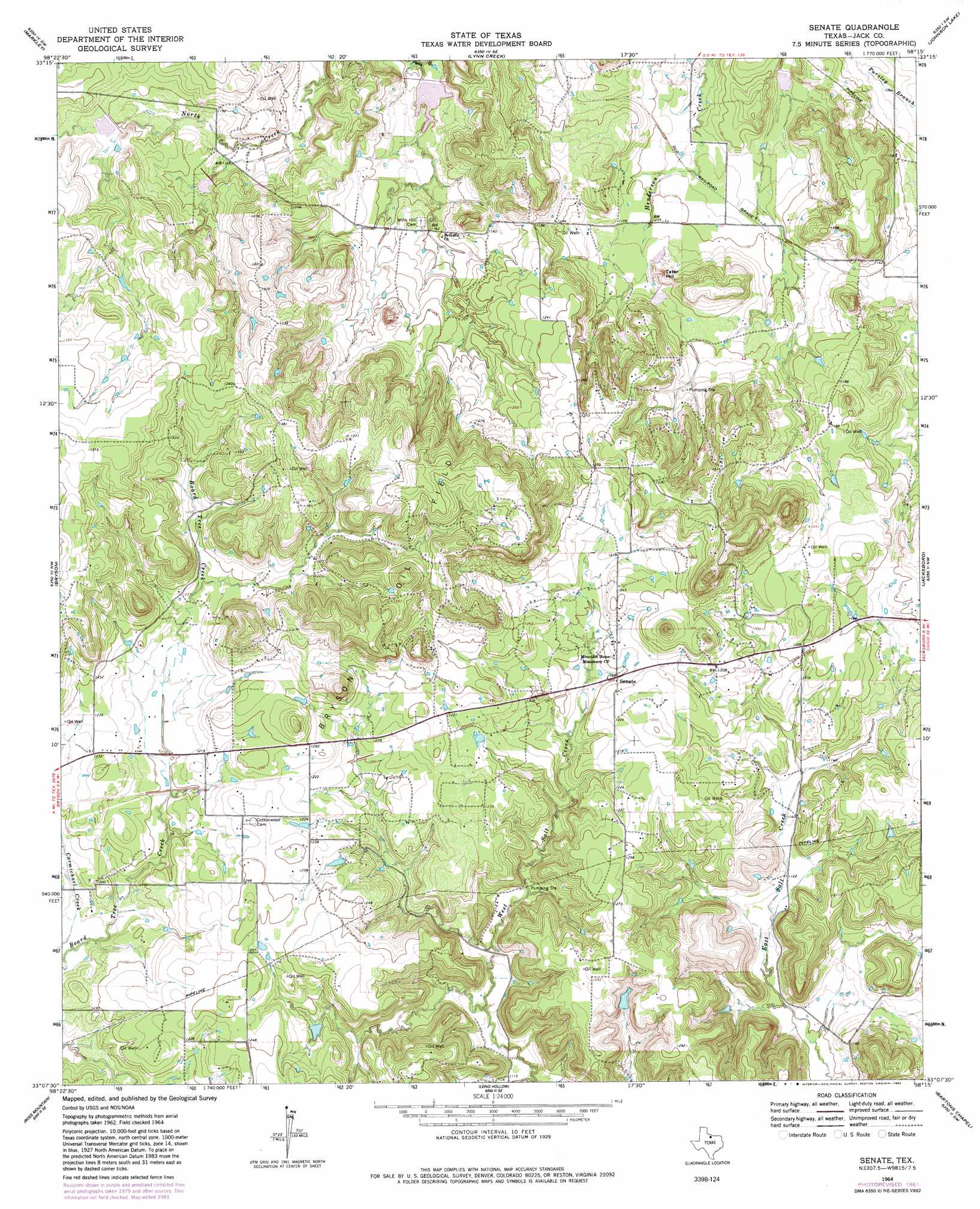
USGS Topo Quad 33098b3 - 1:24,000 scale
| Topo Map Name: | Senate |
| USGS Topo Quad ID: | 33098b3 |
| Print Size: | ca. 21 1/4" wide x 27" high |
| Southeast Coordinates: | 33.125° N latitude / 98.25° W longitude |
| Map Center Coordinates: | 33.1875° N latitude / 98.3125° W longitude |
| U.S. State: | TX |
| Filename: | o33098b3.jpg |
| Download Map JPG Image: | Senate topo map 1:24,000 scale |
| Map Type: | Topographic |
| Topo Series: | 7.5´ |
| Map Scale: | 1:24,000 |
| Source of Map Images: | United States Geological Survey (USGS) |
| Alternate Map Versions: |
Senate TX 1964, updated 1967 Download PDF Buy paper map Senate TX 1964, updated 1982 Download PDF Buy paper map Senate TX 2010 Download PDF Buy paper map Senate TX 2012 Download PDF Buy paper map Senate TX 2016 Download PDF Buy paper map |
1:24,000 Topo Quads surrounding Senate
Prickly Pear Branch |
Darnell Branch |
Antelope |
Postoak |
Newport |
Loving |
Markley |
Lynn Creek |
Johnson Lake |
Cundiff |
Lake Eddleman |
Bryson |
Senate |
Jacksboro |
Jacksboro Ne |
Graham |
Ross Mountain |
Long Hollow |
Bartons Chapel |
Perrin |
Cove Creek |
Costello Island |
Graford West |
Graford East |
Whitt |
> Back to 33098a1 at 1:100,000 scale
> Back to 33098a1 at 1:250,000 scale
> Back to U.S. Topo Maps home
Senate topo map: Gazetteer
Senate: Dams
Dearing Lake Dam elevation 342m 1122′Rhodes Lake Dam elevation 391m 1282′
Soil Conservation Service Site 22 Dam elevation 341m 1118′
Soil Conservation Service Site 23 Dam elevation 322m 1056′
Soil Conservation Service Site 24 Dam elevation 367m 1204′
Soil Conservation Service Site 25 Dam elevation 357m 1171′
Soil Conservation Service Site 28a Dam elevation 334m 1095′
Senate: Oilfields
Bryson Oil Field elevation 400m 1312′Senate: Populated Places
Bob Town elevation 379m 1243′Senate elevation 367m 1204′
Senate: Reservoirs
Dearing Lake elevation 342m 1122′Rhodes Lake elevation 391m 1282′
Soil Conservation Service Site 22 Reservoir elevation 341m 1118′
Soil Conservation Service Site 23 Reservoir elevation 322m 1056′
Soil Conservation Service Site 24 Reservoir elevation 367m 1204′
Soil Conservation Service Site 25 Reservoir elevation 357m 1171′
Soil Conservation Service Site 28a Reservoir elevation 334m 1095′
Senate: Summits
Tater Hill elevation 360m 1181′Senate digital topo map on disk
Buy this Senate topo map showing relief, roads, GPS coordinates and other geographical features, as a high-resolution digital map file on DVD: