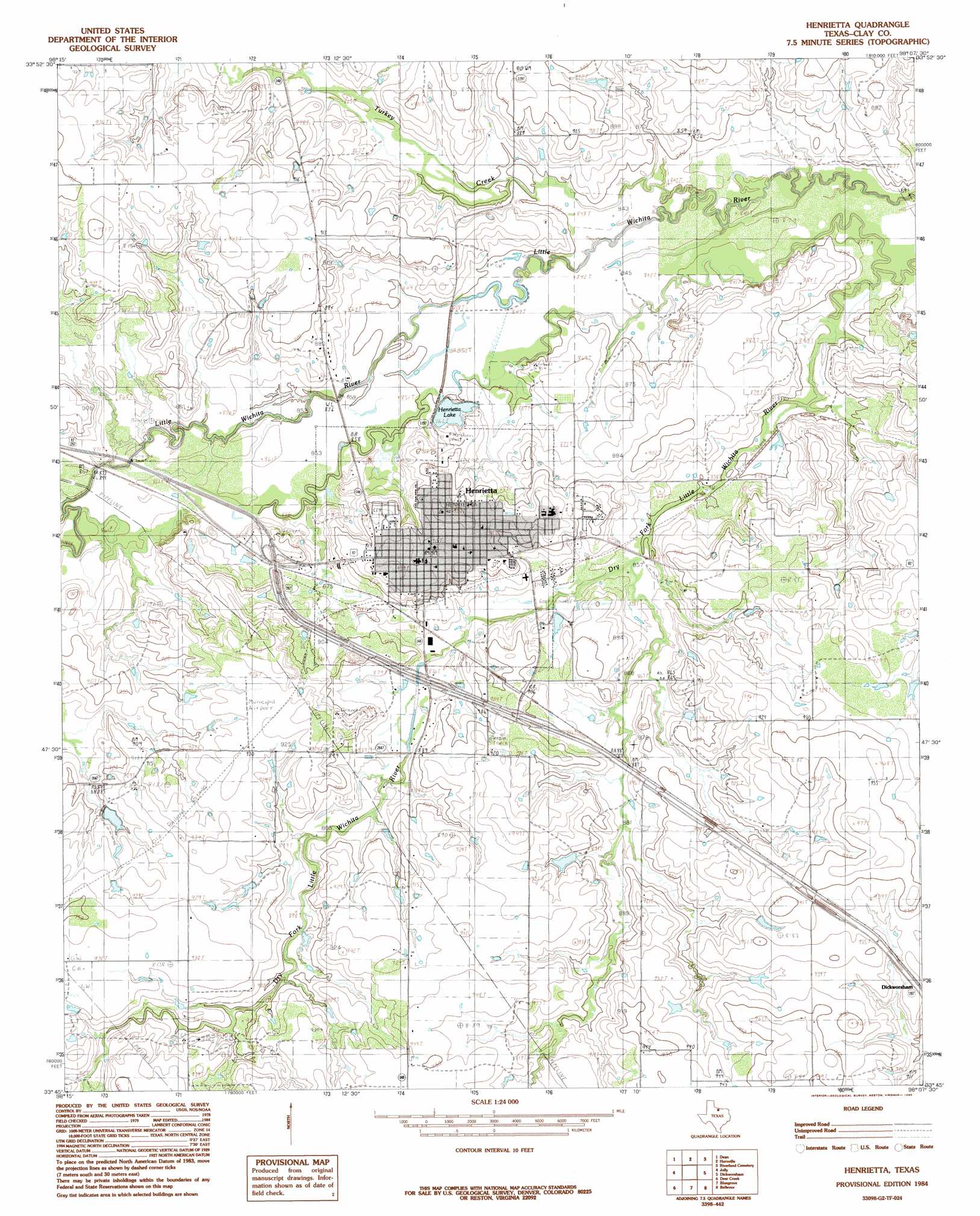
Henrietta Topo Map Texas
To zoom in, hover over the map of Henrietta
USGS Topo Quad 33098g2 - 1:24,000 scale
| Topo Map Name: | Henrietta |
| USGS Topo Quad ID: | 33098g2 |
| Print Size: | ca. 21 1/4" wide x 27" high |
| Southeast Coordinates: | 33.75° N latitude / 98.125° W longitude |
| Map Center Coordinates: | 33.8125° N latitude / 98.1875° W longitude |
| U.S. State: | TX |
| Filename: | o33098g2.jpg |
| Download Map JPG Image: | Henrietta topo map 1:24,000 scale |
| Map Type: | Topographic |
| Topo Series: | 7.5´ |
| Map Scale: | 1:24,000 |
| Source of Map Images: | United States Geological Survey (USGS) |
| Alternate Map Versions: |
Henrietta TX 1984, updated 1985 Download PDF Buy paper map Henrietta TX 2010 Download PDF Buy paper map Henrietta TX 2012 Download PDF Buy paper map Henrietta TX 2016 Download PDF Buy paper map |
1:24,000 Topo Quads surrounding Henrietta
Thornberry |
Charlie |
Byers |
Irving |
Ryan |
Wichita Falls East |
Dean |
Hurnville |
Riverland Cemetery |
Terral |
Sloop Creek |
Jolly |
Henrietta |
Dickworsham |
Ringgold |
Scotland |
Deer Creek |
Bluegrove |
Bellevue |
Stoneburg |
Windthorst |
Scotland Se |
Joy |
Vashti |
Brushy Mound |
> Back to 33098e1 at 1:100,000 scale
> Back to 33098a1 at 1:250,000 scale
> Back to U.S. Topo Maps home
Henrietta topo map: Gazetteer
Henrietta: Airports
Henrietta Airport elevation 273m 895′Pierce Airport elevation 267m 875′
Henrietta: Dams
Clay County Country Club Lake Dam elevation 265m 869′Henrietta City Reservoir 1 Dam elevation 260m 853′
Henrietta Reservoir 2 Dam elevation 256m 839′
Henrietta: Lakes
Henrietta Lake elevation 265m 869′Henrietta: Parks
Hapgood Field elevation 269m 882′Henrietta: Populated Places
Frame elevation 267m 875′Henrietta elevation 278m 912′
Henrietta: Reservoirs
Clay County Country Club Lake elevation 265m 869′Henrietta City Reservoir 1 elevation 260m 853′
Henrietta Reservoir 2 elevation 256m 839′
Henrietta: Streams
Turkey Creek elevation 253m 830′Henrietta digital topo map on disk
Buy this Henrietta topo map showing relief, roads, GPS coordinates and other geographical features, as a high-resolution digital map file on DVD: