Sloop Creek Topo Map Texas
To zoom in, hover over the map of Sloop Creek
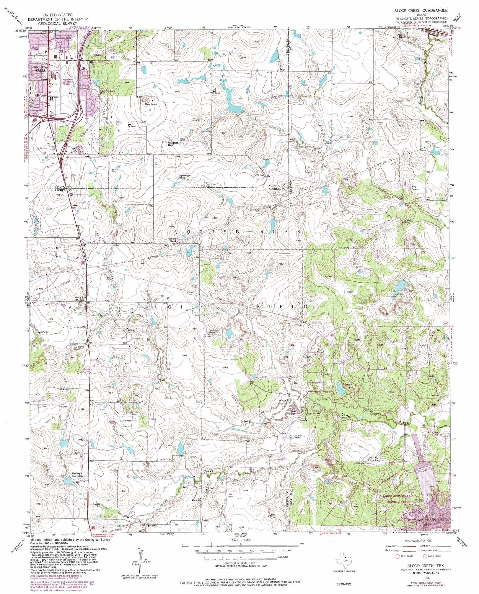
USGS Topo Quad 33098g4 - 1:24,000 scale
| Topo Map Name: | Sloop Creek |
| USGS Topo Quad ID: | 33098g4 |
| Print Size: | ca. 21 1/4" wide x 27" high |
| Southeast Coordinates: | 33.75° N latitude / 98.375° W longitude |
| Map Center Coordinates: | 33.8125° N latitude / 98.4375° W longitude |
| U.S. State: | TX |
| Filename: | o33098g4.jpg |
| Download Map JPG Image: | Sloop Creek topo map 1:24,000 scale |
| Map Type: | Topographic |
| Topo Series: | 7.5´ |
| Map Scale: | 1:24,000 |
| Source of Map Images: | United States Geological Survey (USGS) |
| Alternate Map Versions: |
Sloop Creek TX 1956, updated 1957 Download PDF Buy paper map Sloop Creek TX 1956, updated 1957 Download PDF Buy paper map Sloop Creek TX 1956, updated 1982 Download PDF Buy paper map Sloop Creek TX 2010 Download PDF Buy paper map Sloop Creek TX 2012 Download PDF Buy paper map Sloop Creek TX 2016 Download PDF Buy paper map |
1:24,000 Topo Quads surrounding Sloop Creek
Clara |
Burkburnett |
Thornberry |
Charlie |
Byers |
Iowa Park |
Wichita Falls West |
Wichita Falls East |
Dean |
Hurnville |
Holliday |
Lake Wichita |
Sloop Creek |
Jolly |
Henrietta |
Dads Corner |
Archer City Ne |
Scotland |
Deer Creek |
Bluegrove |
Archer City West |
Archer City East |
Windthorst |
Scotland Se |
Joy |
> Back to 33098e1 at 1:100,000 scale
> Back to 33098a1 at 1:250,000 scale
> Back to U.S. Topo Maps home
Sloop Creek topo map: Gazetteer
Sloop Creek: Airports
Kickapoo Downtown Airpark elevation 300m 984′Sloop Creek: Dams
B and P Lake Number 1 Dam elevation 278m 912′B and P Lake Number 2 Dam elevation 282m 925′
Lee Lake Dam elevation 291m 954′
McGregor Ranch Lake Number 1 Dam elevation 288m 944′
McGregor Ranch Lake Number 2 Dam elevation 294m 964′
Texas No Name Number 41 Dam elevation 291m 954′
Sloop Creek: Lakes
Sloop Pond elevation 274m 898′Sloop Creek: Oilfields
Vogtsberger Oil Field elevation 286m 938′Sloop Creek: Parks
Hursh Park elevation 293m 961′Lake Arrowhead State Park elevation 285m 935′
Loch Lomond Park elevation 297m 974′
Southern Hills Park elevation 296m 971′
Sloop Creek: Reservoirs
B and P Lake Number 2 elevation 282m 925′Lake Number 1 elevation 278m 912′
Lee Lake elevation 291m 954′
McGregor Ranch Lake Number 1 elevation 288m 944′
McGregor Ranch Lake Number 2 elevation 294m 964′
Sloop Creek: Streams
Sloop Creek elevation 273m 895′Sloop Creek: Trails
Lake Arrowhead State Park Trail elevation 291m 954′Sloop Creek digital topo map on disk
Buy this Sloop Creek topo map showing relief, roads, GPS coordinates and other geographical features, as a high-resolution digital map file on DVD: