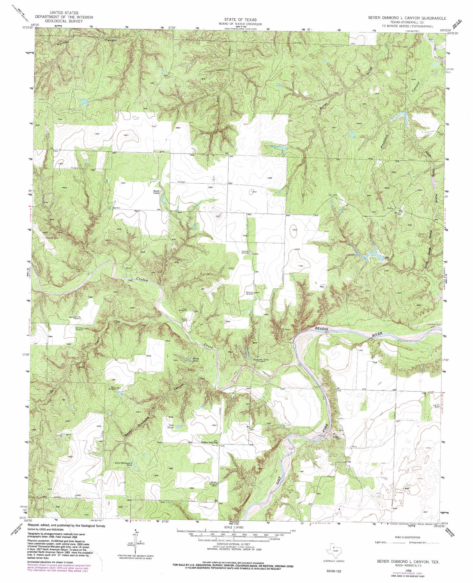
Seven Diamond L Canyon Topo Map Texas
To zoom in, hover over the map of Seven Diamond L Canyon
USGS Topo Quad 33100c4 - 1:24,000 scale
| Topo Map Name: | Seven Diamond L Canyon |
| USGS Topo Quad ID: | 33100c4 |
| Print Size: | ca. 21 1/4" wide x 27" high |
| Southeast Coordinates: | 33.25° N latitude / 100.375° W longitude |
| Map Center Coordinates: | 33.3125° N latitude / 100.4375° W longitude |
| U.S. State: | TX |
| Filename: | o33100c4.jpg |
| Download Map JPG Image: | Seven Diamond L Canyon topo map 1:24,000 scale |
| Map Type: | Topographic |
| Topo Series: | 7.5´ |
| Map Scale: | 1:24,000 |
| Source of Map Images: | United States Geological Survey (USGS) |
| Alternate Map Versions: |
Seven Diamond L Canyon TX 1958, updated 1959 Download PDF Buy paper map Seven Diamond L Canyon TX 1958, updated 1959 Download PDF Buy paper map Seven Diamond L Canyon TX 1958, updated 1981 Download PDF Buy paper map Seven Diamond L Canyon TX 2010 Download PDF Buy paper map Seven Diamond L Canyon TX 2012 Download PDF Buy paper map Seven Diamond L Canyon TX 2016 Download PDF Buy paper map |
1:24,000 Topo Quads surrounding Seven Diamond L Canyon
Croton Camp |
Pitchfork Ranch |
Pitchfork Flats |
Guthrie |
Dark Canyon |
Gilpin |
Pursley House |
Southerland Canyon |
Bob Creek |
Kiowa Peak Nw |
Girard |
Jayton North |
Seven Diamond L Canyon |
Lovers Resort |
Kiowa Peak Sw |
Clairemont East |
Jayton South |
Peacock |
Swenson |
Aspermont |
Gant Hills |
A B C Creek |
Double Mountains |
Coon Hollow |
Aspermont Lake |
> Back to 33100a1 at 1:100,000 scale
> Back to 33100a1 at 1:250,000 scale
> Back to U.S. Topo Maps home
Seven Diamond L Canyon topo map: Gazetteer
Seven Diamond L Canyon: Dams
Homer Brinson Lake Dam elevation 544m 1784′Landreth Lake Dam elevation 520m 1706′
Seven Diamond L Canyon: Reservoirs
Homer Brinson Lake elevation 544m 1784′Landreth Lake elevation 520m 1706′
Perry Tank elevation 536m 1758′
Seven Diamond L Tank elevation 559m 1833′
York Tanks elevation 556m 1824′
Seven Diamond L Canyon: Streams
Croton Creek elevation 518m 1699′Salt Creek elevation 524m 1719′
Seven Diamond L Canyon: Valleys
North Camp Hollow elevation 521m 1709′Pitchfork Canyon elevation 509m 1669′
Seven Diamond L Canyon elevation 523m 1715′
South Camp Hollow elevation 522m 1712′
Seven Diamond L Canyon digital topo map on disk
Buy this Seven Diamond L Canyon topo map showing relief, roads, GPS coordinates and other geographical features, as a high-resolution digital map file on DVD: