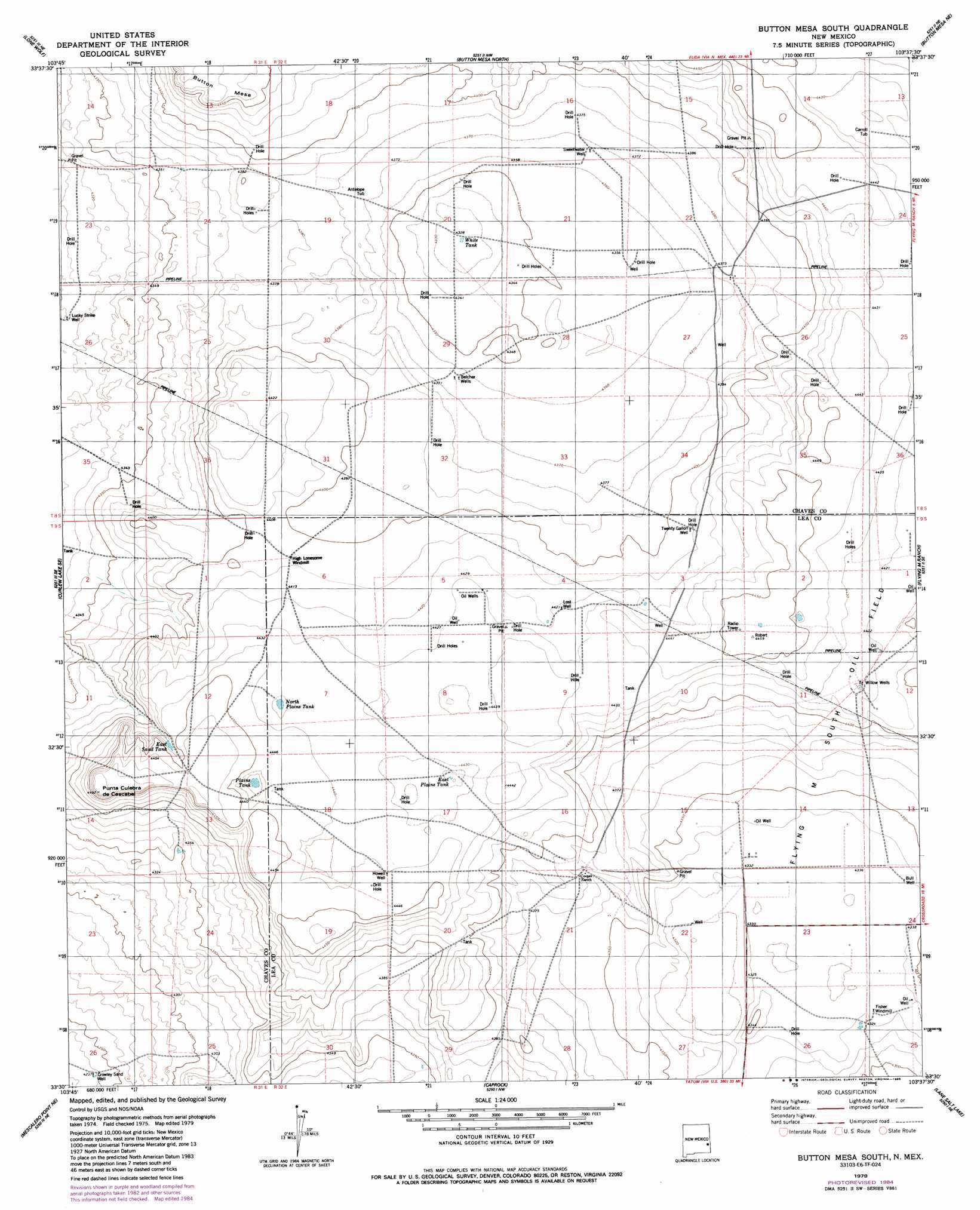
Button Mesa South Topo Map New Mexico
To zoom in, hover over the map of Button Mesa South
USGS Topo Quad 33103e6 - 1:24,000 scale
| Topo Map Name: | Button Mesa South |
| USGS Topo Quad ID: | 33103e6 |
| Print Size: | ca. 21 1/4" wide x 27" high |
| Southeast Coordinates: | 33.5° N latitude / 103.625° W longitude |
| Map Center Coordinates: | 33.5625° N latitude / 103.6875° W longitude |
| U.S. State: | NM |
| Filename: | o33103e6.jpg |
| Download Map JPG Image: | Button Mesa South topo map 1:24,000 scale |
| Map Type: | Topographic |
| Topo Series: | 7.5´ |
| Map Scale: | 1:24,000 |
| Source of Map Images: | United States Geological Survey (USGS) |
| Alternate Map Versions: |
Button Mesa South NM 1979, updated 1985 Download PDF Buy paper map Button Mesa South NM 2010 Download PDF Buy paper map Button Mesa South NM 2013 Download PDF Buy paper map Button Mesa South NM 2017 Download PDF Buy paper map |
1:24,000 Topo Quads surrounding Button Mesa South
Kenna Sw |
Kenna |
Schram Lake |
Elida Se |
Dora Sw |
Curlew Lake |
Lone Wolf |
Button Mesa North |
Button Mesa Ne |
Milnesand Nw |
Presler Lake |
Curlew Lake Se |
Button Mesa South |
Flying M Ranch |
Milnesand Sw |
Oasis |
Mescalero Point Ne |
Caprock |
Lane Salt Lake |
Johnson Ranch |
Culp Ranch |
Mescalero Point |
Soldier Hill |
Dallas Store |
Simanola Valley |
> Back to 33103e1 at 1:100,000 scale
> Back to 33102a1 at 1:250,000 scale
> Back to U.S. Topo Maps home
Button Mesa South topo map: Gazetteer
Button Mesa South: Reservoirs
East Plains Tank elevation 1348m 4422′East Sand Tank elevation 1352m 4435′
North Plains Tank elevation 1351m 4432′
Plains Tank elevation 1349m 4425′
White Tank elevation 1319m 4327′
Button Mesa South: Summits
Punta Culebra de Cascade elevation 1371m 4498′Button Mesa South: Wells
12508 Water Well elevation 1351m 4432′12509 Water Well elevation 1347m 4419′
12510 Water Well elevation 1331m 4366′
12511 Water Well elevation 1330m 4363′
12512 Water Well elevation 1323m 4340′
12513 Water Well elevation 1318m 4324′
13371 Water Well elevation 1347m 4419′
Antelope Tub elevation 1333m 4373′
Belcher Wells elevation 1330m 4363′
Bull Well elevation 1323m 4340′
Carroll Tub elevation 1351m 4432′
Crowley Sand elevation 1292m 4238′
Drill Hole Twenty Gallon Well elevation 1345m 4412′
Howell Well elevation 1354m 4442′
Lost Well elevation 1348m 4422′
Lucky Strike Well elevation 1315m 4314′
Sweetwater Well elevation 1332m 4370′
Willow Wells elevation 1348m 4422′
Button Mesa South digital topo map on disk
Buy this Button Mesa South topo map showing relief, roads, GPS coordinates and other geographical features, as a high-resolution digital map file on DVD: