Bluit Topo Map New Mexico
To zoom in, hover over the map of Bluit
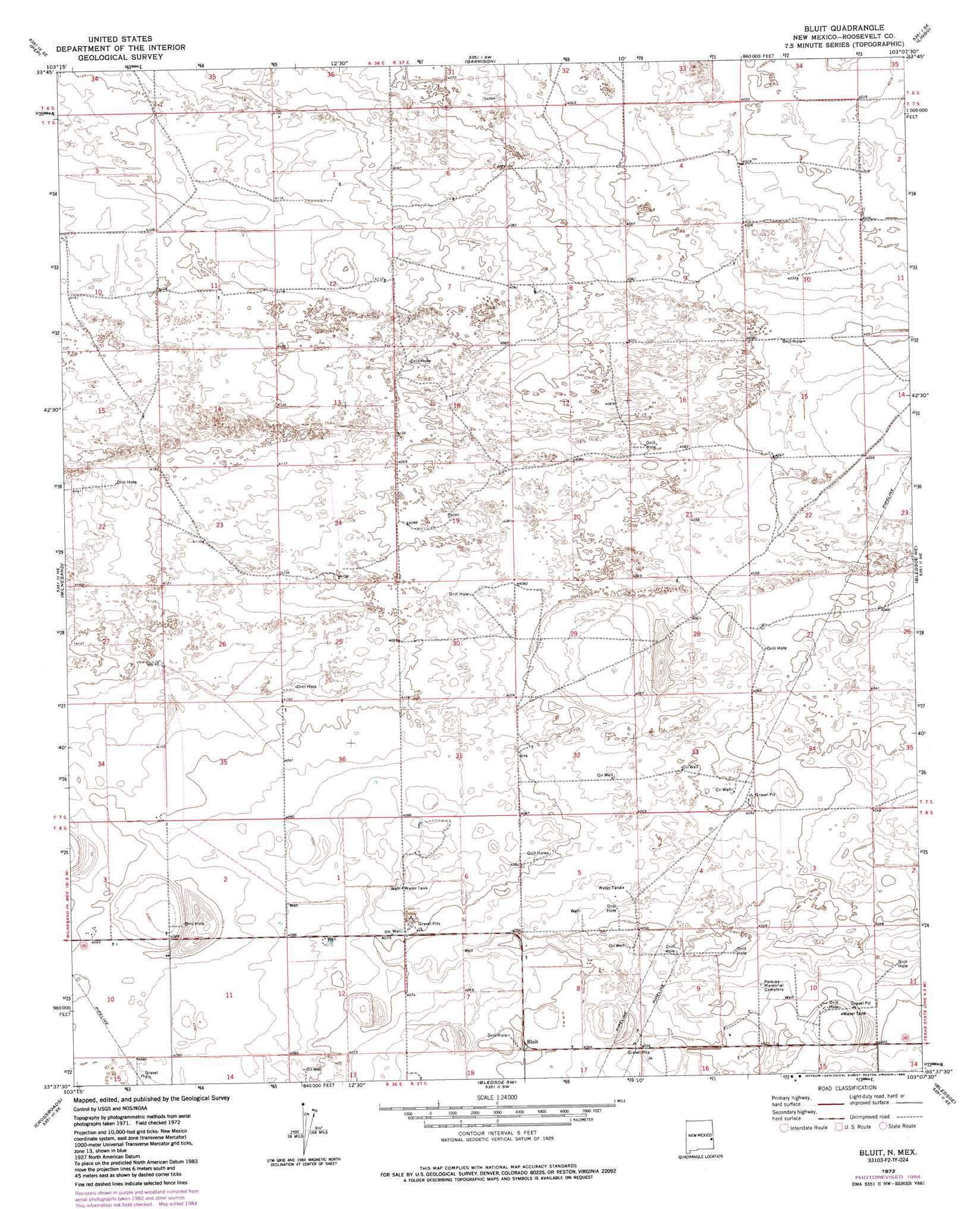
USGS Topo Quad 33103f2 - 1:24,000 scale
| Topo Map Name: | Bluit |
| USGS Topo Quad ID: | 33103f2 |
| Print Size: | ca. 21 1/4" wide x 27" high |
| Southeast Coordinates: | 33.625° N latitude / 103.125° W longitude |
| Map Center Coordinates: | 33.6875° N latitude / 103.1875° W longitude |
| U.S. State: | NM |
| Filename: | o33103f2.jpg |
| Download Map JPG Image: | Bluit topo map 1:24,000 scale |
| Map Type: | Topographic |
| Topo Series: | 7.5´ |
| Map Scale: | 1:24,000 |
| Source of Map Images: | United States Geological Survey (USGS) |
| Alternate Map Versions: |
Bluit NM 1972, updated 1975 Download PDF Buy paper map Bluit NM 1972, updated 1985 Download PDF Buy paper map Bluit NM 2010 Download PDF Buy paper map Bluit NM 2013 Download PDF Buy paper map Bluit NM 2017 Download PDF Buy paper map |
1:24,000 Topo Quads surrounding Bluit
Dora Nw |
Dora |
Causey West |
Causey East |
Three Way School |
Dora Sw |
Pep |
Garrison |
Lingo |
Maple |
Milnesand Nw |
Milnesand |
Bluit |
Bledsoe Ne |
Morton Nw |
Milnesand Sw |
Crossroads |
Bledsoe Sw |
Bledsoe |
Morton Sw |
Johnson Ranch |
Ranger Lake |
Walking Cane Ranch |
Bronco Ne |
Two B Ranch Nw |
> Back to 33103e1 at 1:100,000 scale
> Back to 33102a1 at 1:250,000 scale
> Back to U.S. Topo Maps home
Bluit topo map: Gazetteer
Bluit: Populated Places
Bluit elevation 1235m 4051′Bluit: Post Offices
Bluitt Post Office (historical) elevation 1235m 4051′Bluit: Wells
11523 Water Well elevation 1259m 4130′11525 Water Well elevation 1224m 4015′
11526 Water Well elevation 1231m 4038′
11527 Water Well elevation 1248m 4094′
11528 Water Well elevation 1233m 4045′
11529 Water Well elevation 1232m 4041′
11531 Water Well elevation 1232m 4041′
11532 Water Well elevation 1249m 4097′
12561 Water Well elevation 1251m 4104′
12562 Water Well elevation 1262m 4140′
12563 Water Well elevation 1253m 4110′
12564 Water Well elevation 1254m 4114′
12565 Water Well elevation 1251m 4104′
12566 Water Well elevation 1255m 4117′
12568 Water Well elevation 1248m 4094′
12569 Water Well elevation 1245m 4084′
12570 Water Well elevation 1249m 4097′
12580 Water Well elevation 1238m 4061′
12581 Water Well elevation 1245m 4084′
12582 Water Well elevation 1244m 4081′
12583 Water Well elevation 1234m 4048′
12602 Water Well elevation 1244m 4081′
12605 Water Well elevation 1245m 4084′
12614 Water Well elevation 1237m 4058′
12615 Water Well elevation 1245m 4084′
12616 Water Well elevation 1242m 4074′
12617 Water Well elevation 1232m 4041′
12618 Water Well elevation 1226m 4022′
12622 Water Well elevation 1226m 4022′
12623 Water Well elevation 1237m 4058′
12692 Water Well elevation 1250m 4101′
Bluit digital topo map on disk
Buy this Bluit topo map showing relief, roads, GPS coordinates and other geographical features, as a high-resolution digital map file on DVD: