Button Mesa Ne Topo Map New Mexico
To zoom in, hover over the map of Button Mesa Ne
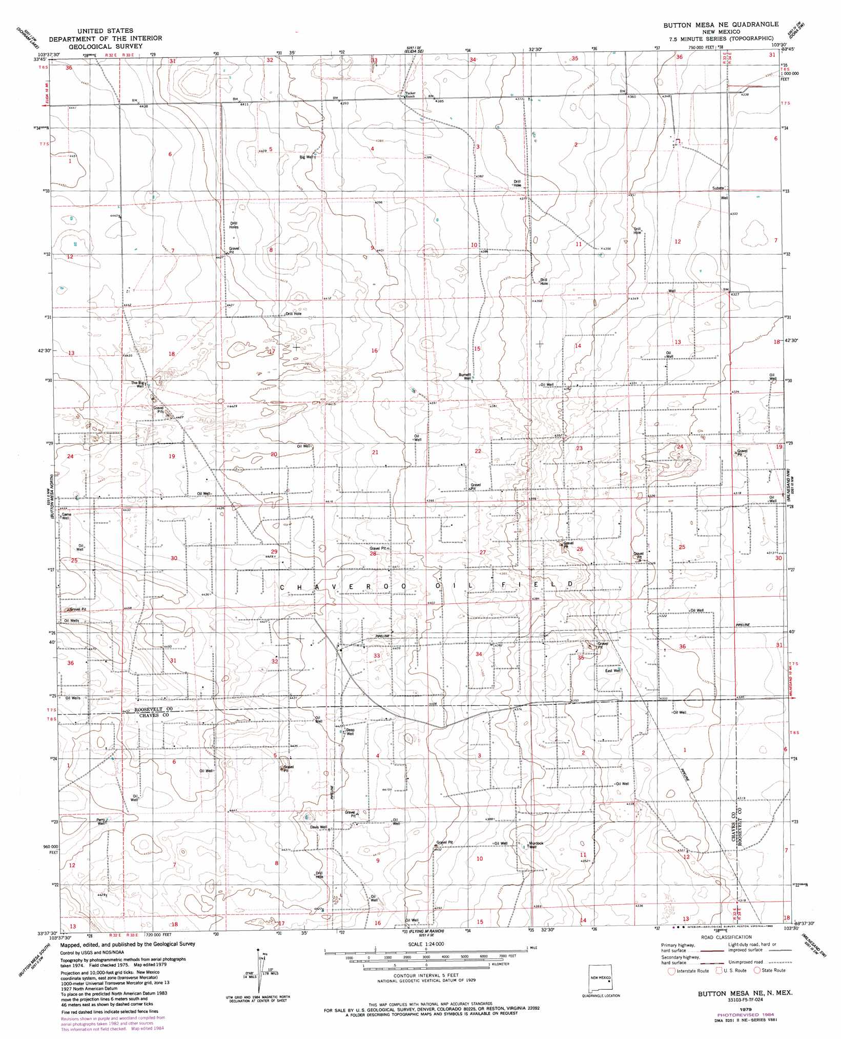
USGS Topo Quad 33103f5 - 1:24,000 scale
| Topo Map Name: | Button Mesa Ne |
| USGS Topo Quad ID: | 33103f5 |
| Print Size: | ca. 21 1/4" wide x 27" high |
| Southeast Coordinates: | 33.625° N latitude / 103.5° W longitude |
| Map Center Coordinates: | 33.6875° N latitude / 103.5625° W longitude |
| U.S. State: | NM |
| Filename: | o33103f5.jpg |
| Download Map JPG Image: | Button Mesa Ne topo map 1:24,000 scale |
| Map Type: | Topographic |
| Topo Series: | 7.5´ |
| Map Scale: | 1:24,000 |
| Source of Map Images: | United States Geological Survey (USGS) |
| Alternate Map Versions: |
Button Mesa NE NM 1979, updated 1986 Download PDF Buy paper map Button Mesa NE NM 2010 Download PDF Buy paper map Button Mesa NE NM 2013 Download PDF Buy paper map Button Mesa NE NM 2017 Download PDF Buy paper map |
1:24,000 Topo Quads surrounding Button Mesa Ne
San Juan Mesa East |
Elida |
Badger Lake |
Dora Nw |
Dora |
Kenna |
Schram Lake |
Elida Se |
Dora Sw |
Pep |
Lone Wolf |
Button Mesa North |
Button Mesa Ne |
Milnesand Nw |
Milnesand |
Curlew Lake Se |
Button Mesa South |
Flying M Ranch |
Milnesand Sw |
Crossroads |
Mescalero Point Ne |
Caprock |
Lane Salt Lake |
Johnson Ranch |
Ranger Lake |
> Back to 33103e1 at 1:100,000 scale
> Back to 33102a1 at 1:250,000 scale
> Back to U.S. Topo Maps home
Button Mesa Ne topo map: Gazetteer
Button Mesa Ne: Oilfields
Chaveroo Oil Field elevation 1343m 4406′Button Mesa Ne: Wells
06186 Water Well elevation 1343m 4406′06187 Water Well elevation 1328m 4356′
06208 Water Well elevation 1355m 4445′
06210 Water Well elevation 1340m 4396′
06211 Water Well elevation 1354m 4442′
06214 Water Well elevation 1341m 4399′
06215 Water Well elevation 1354m 4442′
06216 Water Well elevation 1340m 4396′
06217 Water Well elevation 1349m 4425′
06218 Water Well elevation 1322m 4337′
06219 Water Well elevation 1319m 4327′
12548 Water Well elevation 1322m 4337′
Big Well elevation 1341m 4399′
Burnett Well elevation 1336m 4383′
Davis Well elevation 1347m 4419′
Deep Well elevation 1349m 4425′
Game Well elevation 1355m 4445′
Murdock Well elevation 1331m 4366′
Perry Well elevation 1358m 4455′
The Big Well elevation 1351m 4432′
Button Mesa Ne digital topo map on disk
Buy this Button Mesa Ne topo map showing relief, roads, GPS coordinates and other geographical features, as a high-resolution digital map file on DVD: