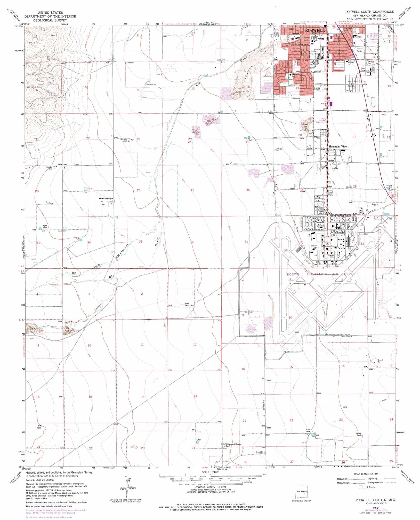
Roswell South Topo Map New Mexico
To zoom in, hover over the map of Roswell South
USGS Topo Quad 33104c5 - 1:24,000 scale
| Topo Map Name: | Roswell South |
| USGS Topo Quad ID: | 33104c5 |
| Print Size: | ca. 21 1/4" wide x 27" high |
| Southeast Coordinates: | 33.25° N latitude / 104.5° W longitude |
| Map Center Coordinates: | 33.3125° N latitude / 104.5625° W longitude |
| U.S. State: | NM |
| Filename: | o33104c5.jpg |
| Download Map JPG Image: | Roswell South topo map 1:24,000 scale |
| Map Type: | Topographic |
| Topo Series: | 7.5´ |
| Map Scale: | 1:24,000 |
| Source of Map Images: | United States Geological Survey (USGS) |
| Alternate Map Versions: |
Roswell South NM 1949 Download PDF Buy paper map Roswell South NM 1962, updated 1964 Download PDF Buy paper map Roswell South NM 1962, updated 1977 Download PDF Buy paper map Roswell South NM 2010 Download PDF Buy paper map Roswell South NM 2013 Download PDF Buy paper map Roswell South NM 2017 Download PDF Buy paper map |
1:24,000 Topo Quads surrounding Roswell South
White Flat Se |
Barn Draw |
Panther Hill |
Melena |
Acme |
Blackwater Hill |
Corn Ranch |
Roswell North |
Bitter Lake |
Comanche Spring |
Diamond A Ranch |
Hondo Reservoir |
Roswell South |
South Spring |
Bottomless Lakes |
Lucky Lake |
Juan Lake |
Peters Lake |
Dexter West |
Dexter East |
Indian Bluff |
Kincaid Ranch |
Hackberry Ranch |
Hagerman Sw |
Hagerman |
> Back to 33104a1 at 1:100,000 scale
> Back to 33104a1 at 1:250,000 scale
> Back to U.S. Topo Maps home
Roswell South topo map: Gazetteer
Roswell South: Airports
Roswell Industrial Air Center Airport elevation 1114m 3654′Roswell South: Mines
Brasher Pit elevation 1113m 3651′Chaves County Pit elevation 1102m 3615′
Crusher Pit elevation 1111m 3645′
Mullinix Pit elevation 1147m 3763′
Roswell Ready Mix Pit elevation 1116m 3661′
Roswell South: Parks
Carpenter Park elevation 1099m 3605′Roswell South: Populated Places
Mountain View elevation 1106m 3628′Roswell South: Streams
Hondo elevation 1128m 3700′Rocky Arroyo elevation 1136m 3727′
Roswell South digital topo map on disk
Buy this Roswell South topo map showing relief, roads, GPS coordinates and other geographical features, as a high-resolution digital map file on DVD: