Roswell North Topo Map New Mexico
To zoom in, hover over the map of Roswell North
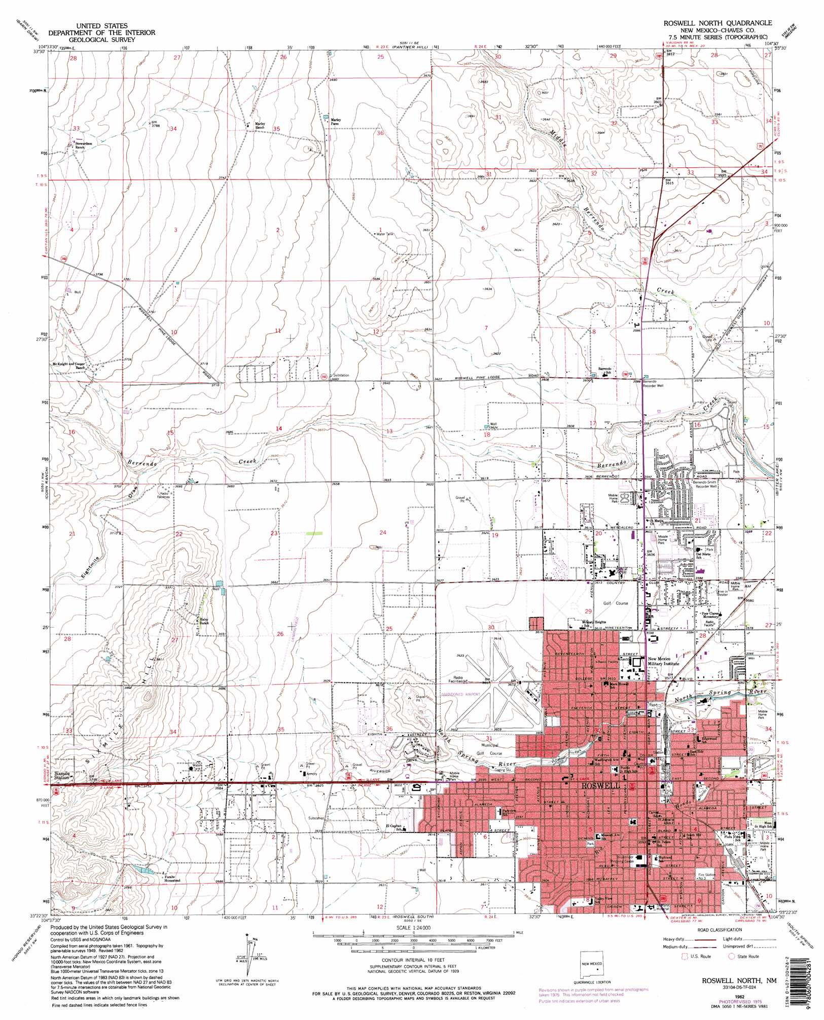
USGS Topo Quad 33104d5 - 1:24,000 scale
| Topo Map Name: | Roswell North |
| USGS Topo Quad ID: | 33104d5 |
| Print Size: | ca. 21 1/4" wide x 27" high |
| Southeast Coordinates: | 33.375° N latitude / 104.5° W longitude |
| Map Center Coordinates: | 33.4375° N latitude / 104.5625° W longitude |
| U.S. State: | NM |
| Filename: | o33104d5.jpg |
| Download Map JPG Image: | Roswell North topo map 1:24,000 scale |
| Map Type: | Topographic |
| Topo Series: | 7.5´ |
| Map Scale: | 1:24,000 |
| Source of Map Images: | United States Geological Survey (USGS) |
| Alternate Map Versions: |
Roswell North NM 1949 Download PDF Buy paper map Roswell North NM 1962, updated 1964 Download PDF Buy paper map Roswell North NM 1962, updated 1977 Download PDF Buy paper map Roswell North NM 1962, updated 1995 Download PDF Buy paper map Roswell North NM 2010 Download PDF Buy paper map Roswell North NM 2013 Download PDF Buy paper map Roswell North NM 2017 Download PDF Buy paper map |
1:24,000 Topo Quads surrounding Roswell North
Deep Well |
Rock House Canyon |
Marley Draw |
Coyote Draw |
Eightmile Draw |
White Flat Se |
Barn Draw |
Panther Hill |
Melena |
Acme |
Blackwater Hill |
Corn Ranch |
Roswell North |
Bitter Lake |
Comanche Spring |
Diamond A Ranch |
Hondo Reservoir |
Roswell South |
South Spring |
Bottomless Lakes |
Lucky Lake |
Juan Lake |
Peters Lake |
Dexter West |
Dexter East |
> Back to 33104a1 at 1:100,000 scale
> Back to 33104a1 at 1:250,000 scale
> Back to U.S. Topo Maps home
Roswell North topo map: Gazetteer
Roswell North: Airports
Two Link Ranch Airport elevation 1100m 3608′Roswell North: Parks
Cahoon Park elevation 1089m 3572′Castano de Sosas Route Historical Marker elevation 1090m 3576′
Chisum Trail Historical Marker elevation 1090m 3576′
Chisums South Springs Ranch Historical Marker elevation 1090m 3576′
High Plains Historical Marker elevation 1090m 3576′
Hondo Park elevation 1087m 3566′
Roswell North: Populated Places
Berrendo (historical) elevation 1094m 3589′Roswell elevation 1090m 3576′
Roswell North: Post Offices
Roswell Post Office elevation 1090m 3576′Roswell North: Valleys
Eightmile Draw elevation 1122m 3681′Roswell North: Wells
Berrendo Recorder Well elevation 1094m 3589′Berrendo-Smith Recorder Well elevation 1092m 3582′
Roswell North digital topo map on disk
Buy this Roswell North topo map showing relief, roads, GPS coordinates and other geographical features, as a high-resolution digital map file on DVD: