Turkey Peak Topo Map New Mexico
To zoom in, hover over the map of Turkey Peak
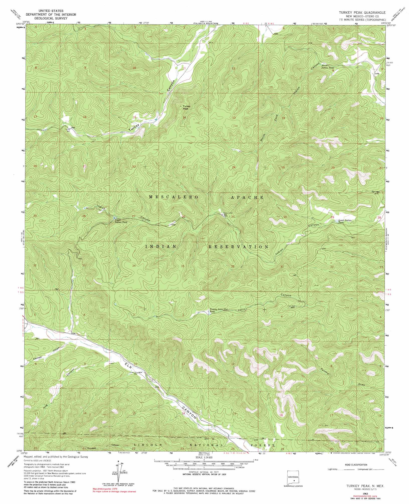
USGS Topo Quad 33105a4 - 1:24,000 scale
| Topo Map Name: | Turkey Peak |
| USGS Topo Quad ID: | 33105a4 |
| Print Size: | ca. 21 1/4" wide x 27" high |
| Southeast Coordinates: | 33° N latitude / 105.375° W longitude |
| Map Center Coordinates: | 33.0625° N latitude / 105.4375° W longitude |
| U.S. State: | NM |
| Filename: | o33105a4.jpg |
| Download Map JPG Image: | Turkey Peak topo map 1:24,000 scale |
| Map Type: | Topographic |
| Topo Series: | 7.5´ |
| Map Scale: | 1:24,000 |
| Source of Map Images: | United States Geological Survey (USGS) |
| Alternate Map Versions: |
Turkey Peak NM 1963, updated 1966 Download PDF Buy paper map Turkey Peak NM 1963, updated 1982 Download PDF Buy paper map Turkey Peak NM 2004, updated 2006 Download PDF Buy paper map Turkey Peak NM 2011 Download PDF Buy paper map Turkey Peak NM 2013 Download PDF Buy paper map |
| FStopo: | US Forest Service topo Turkey Peak is available: Download FStopo PDF Download FStopo TIF |
1:24,000 Topo Quads surrounding Turkey Peak
Ruidoso |
Ruidoso Downs |
Sheeppen Canyon |
Wahalee Canyon |
Tinnie |
Apache Summit |
Whitetail |
Pajarita Mountain |
Deadman Lake |
Flying H Nw |
Firman Canyon |
Elk-Silver |
Turkey Peak |
Clements Ranch |
Loco Canyon |
Cloudcroft |
Harvey Ranch |
Mayhill |
Elk |
Thimble Canyon |
Bluff Springs |
Sacramento |
Woodson Canyon |
Robertson Canyon |
Dunken |
> Back to 33105a1 at 1:100,000 scale
> Back to 33104a1 at 1:250,000 scale
> Back to U.S. Topo Maps home
Turkey Peak topo map: Gazetteer
Turkey Peak: Reservoirs
Crooked Tank elevation 2298m 7539′Lower Indian Tank elevation 1984m 6509′
North Indian Tank elevation 2019m 6624′
Tommy Jones Flat Tank elevation 2148m 7047′
Upper Indian Tank elevation 2175m 7135′
Turkey Peak: Summits
Turkey Peak elevation 2236m 7335′Turkey Peak: Valleys
Clement Canyon elevation 2060m 6758′Hog Canyon elevation 2047m 6715′
Turkey Peak digital topo map on disk
Buy this Turkey Peak topo map showing relief, roads, GPS coordinates and other geographical features, as a high-resolution digital map file on DVD: