Elk-Silver Topo Map New Mexico
To zoom in, hover over the map of Elk-Silver
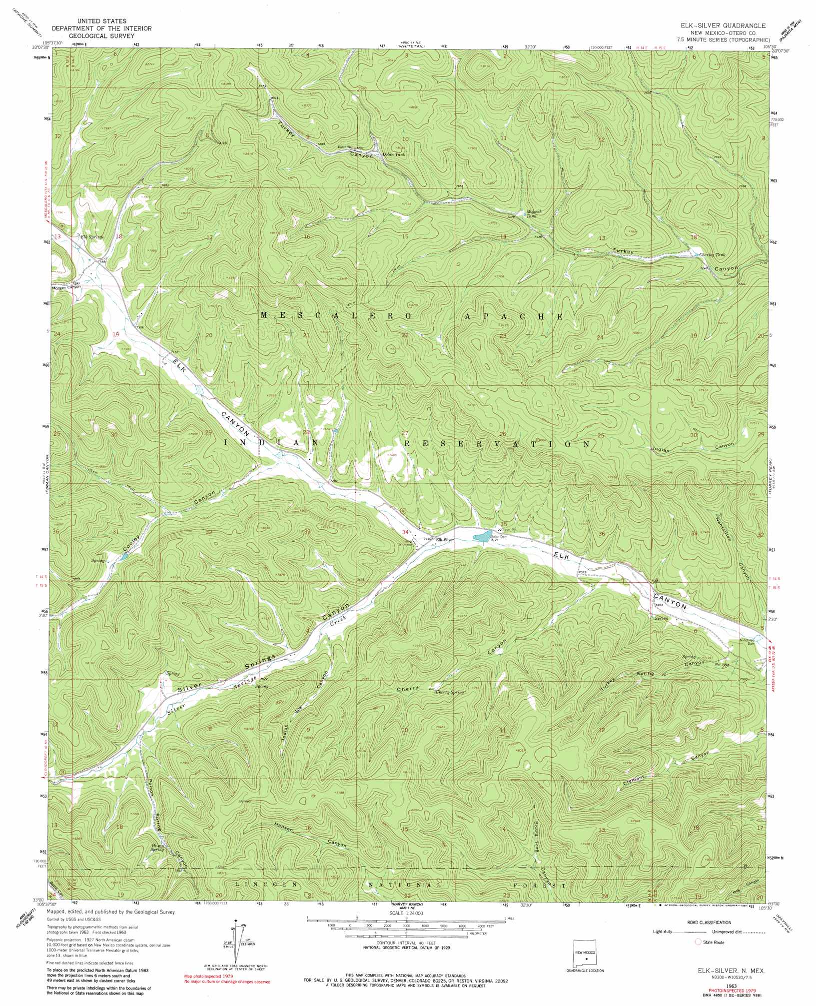
USGS Topo Quad 33105a5 - 1:24,000 scale
| Topo Map Name: | Elk-Silver |
| USGS Topo Quad ID: | 33105a5 |
| Print Size: | ca. 21 1/4" wide x 27" high |
| Southeast Coordinates: | 33° N latitude / 105.5° W longitude |
| Map Center Coordinates: | 33.0625° N latitude / 105.5625° W longitude |
| U.S. State: | NM |
| Filename: | o33105a5.jpg |
| Download Map JPG Image: | Elk-Silver topo map 1:24,000 scale |
| Map Type: | Topographic |
| Topo Series: | 7.5´ |
| Map Scale: | 1:24,000 |
| Source of Map Images: | United States Geological Survey (USGS) |
| Alternate Map Versions: |
Elk-Silver NM 1963, updated 1967 Download PDF Buy paper map Elk-Silver NM 1963, updated 1981 Download PDF Buy paper map Elk-Silver NM 2004, updated 2006 Download PDF Buy paper map Elk-Silver NM 2011 Download PDF Buy paper map Elk-Silver NM 2013 Download PDF Buy paper map |
| FStopo: | US Forest Service topo Elk-Silver is available: Download FStopo PDF Download FStopo TIF |
1:24,000 Topo Quads surrounding Elk-Silver
Sierra Blanca Peak |
Ruidoso |
Ruidoso Downs |
Sheeppen Canyon |
Wahalee Canyon |
Mescalero |
Apache Summit |
Whitetail |
Pajarita Mountain |
Deadman Lake |
Domingo Peak |
Firman Canyon |
Elk-Silver |
Turkey Peak |
Clements Ranch |
High Rolls |
Cloudcroft |
Harvey Ranch |
Mayhill |
Elk |
Sacramento Peak |
Bluff Springs |
Sacramento |
Woodson Canyon |
Robertson Canyon |
> Back to 33105a1 at 1:100,000 scale
> Back to 33104a1 at 1:250,000 scale
> Back to U.S. Topo Maps home
Elk-Silver topo map: Gazetteer
Elk-Silver: Dams
Cooley Canyon Dam Number 2 elevation 2355m 7726′Nahtzillee Dam elevation 2090m 6856′
Solon Dam elevation 2170m 7119′
Elk-Silver: Populated Places
Silver Springs elevation 2317m 7601′Elk-Silver: Reservoirs
Charley Tank elevation 2214m 7263′Dolan Tank elevation 2361m 7746′
Mogoosh Tank elevation 2284m 7493′
Elk-Silver: Springs
Cherry Spring elevation 2270m 7447′Elk Springs elevation 2317m 7601′
Poison Spring elevation 2367m 7765′
Elk-Silver: Streams
Silver Springs Creek elevation 2180m 7152′Elk-Silver: Valleys
Cherry Canyon elevation 2138m 7014′Cooley Canyon elevation 2230m 7316′
Indian Joe Canyon elevation 2234m 7329′
Morgan Canyon elevation 2296m 7532′
Nahtzillee Canyon elevation 2089m 6853′
Silver Springs Canyon elevation 2181m 7155′
Turkey Spring Canyon elevation 2089m 6853′
Elk-Silver digital topo map on disk
Buy this Elk-Silver topo map showing relief, roads, GPS coordinates and other geographical features, as a high-resolution digital map file on DVD: