Sabinata Flat Topo Map New Mexico
To zoom in, hover over the map of Sabinata Flat
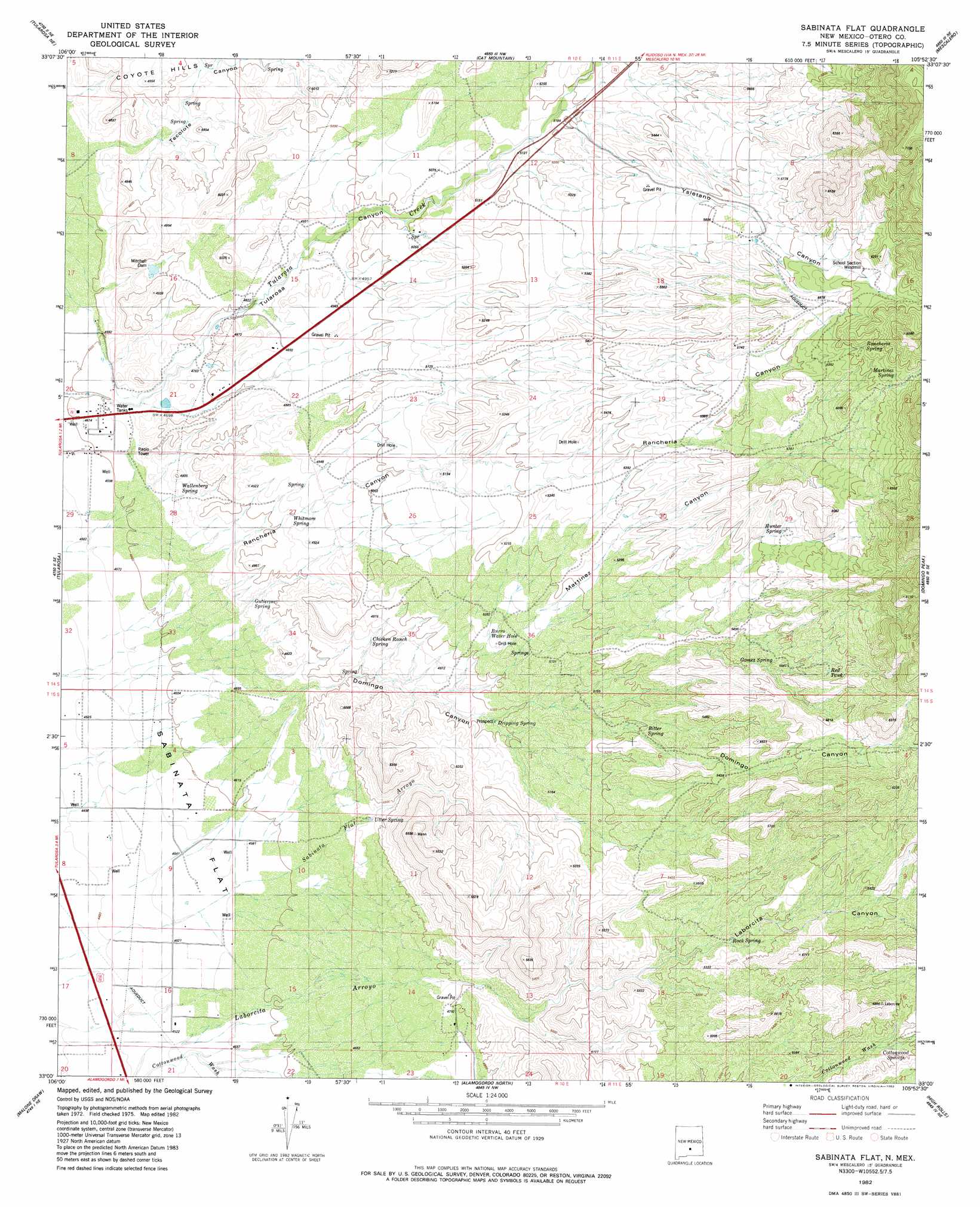
USGS Topo Quad 33105a8 - 1:24,000 scale
| Topo Map Name: | Sabinata Flat |
| USGS Topo Quad ID: | 33105a8 |
| Print Size: | ca. 21 1/4" wide x 27" high |
| Southeast Coordinates: | 33° N latitude / 105.875° W longitude |
| Map Center Coordinates: | 33.0625° N latitude / 105.9375° W longitude |
| U.S. State: | NM |
| Filename: | o33105a8.jpg |
| Download Map JPG Image: | Sabinata Flat topo map 1:24,000 scale |
| Map Type: | Topographic |
| Topo Series: | 7.5´ |
| Map Scale: | 1:24,000 |
| Source of Map Images: | United States Geological Survey (USGS) |
| Alternate Map Versions: |
Sabinata Flat NM 1982, updated 1982 Download PDF Buy paper map Sabinata Flat NM 2010 Download PDF Buy paper map Sabinata Flat NM 2013 Download PDF Buy paper map |
1:24,000 Topo Quads surrounding Sabinata Flat
Three Rivers Sw |
Three Rivers |
Golondrina Draw |
Sierra Blanca Peak |
Ruidoso |
Bitter Creek |
Tularosa Ne |
Cat Mountain |
Mescalero |
Apache Summit |
Tularosa Peak |
Tularosa |
Sabinata Flat |
Domingo Peak |
Firman Canyon |
Lost River |
Malone Draw |
Alamogordo North |
High Rolls |
Cloudcroft |
Garton Lake |
Holloman |
Alamogordo South |
Sacramento Peak |
Bluff Springs |
> Back to 33105a1 at 1:100,000 scale
> Back to 33104a1 at 1:250,000 scale
> Back to U.S. Topo Maps home
Sabinata Flat topo map: Gazetteer
Sabinata Flat: Arroyos
Sabinata Flat Arroyo elevation 1379m 4524′Sabinata Flat: Dams
Mitchell Dam elevation 1442m 4730′Sabinata Flat: Flats
Sabinata Flat elevation 1383m 4537′Sabinata Flat: Mines
Armstrong and Armstrong Rock elevation 1635m 5364′Sabinata Flat: Populated Places
Alamorosa elevation 1364m 4475′Sabinata Flat: Reservoirs
Red Tank elevation 1743m 5718′Sabinata Flat: Springs
Bitter Spring elevation 1598m 5242′Burro Water Hole elevation 1537m 5042′
Chicken Ranch Spring elevation 1489m 4885′
Cottonwood Canyon elevation 1694m 5557′
Dripping Spring elevation 1512m 4960′
Gomez Spring elevation 1684m 5524′
Gutierrez Spring elevation 1434m 4704′
Hunter Spring elevation 1741m 5711′
Martinez Spring elevation 1853m 6079′
Rancheria Spring elevation 1851m 6072′
Rock Spring elevation 1618m 5308′
Utter Spring elevation 1439m 4721′
Wallenberg Spring elevation 1427m 4681′
Whitmore Spring elevation 1478m 4849′
Sabinata Flat: Streams
Sabinata Flat Arroyo elevation 1378m 4520′Sabinata Flat: Valleys
Domingo Canyon elevation 1370m 4494′Laborcita Canyon elevation 1462m 4796′
Martinez Canyon elevation 1489m 4885′
Rancheria Canyon elevation 1397m 4583′
Tularosa Canyon elevation 1417m 4648′
Ysletano Canyon elevation 1543m 5062′
Sabinata Flat: Wells
10026 Water Well elevation 1402m 4599′10628 Water Well elevation 1369m 4491′
Sabinata Flat digital topo map on disk
Buy this Sabinata Flat topo map showing relief, roads, GPS coordinates and other geographical features, as a high-resolution digital map file on DVD: