Golondrina Draw Topo Map New Mexico
To zoom in, hover over the map of Golondrina Draw
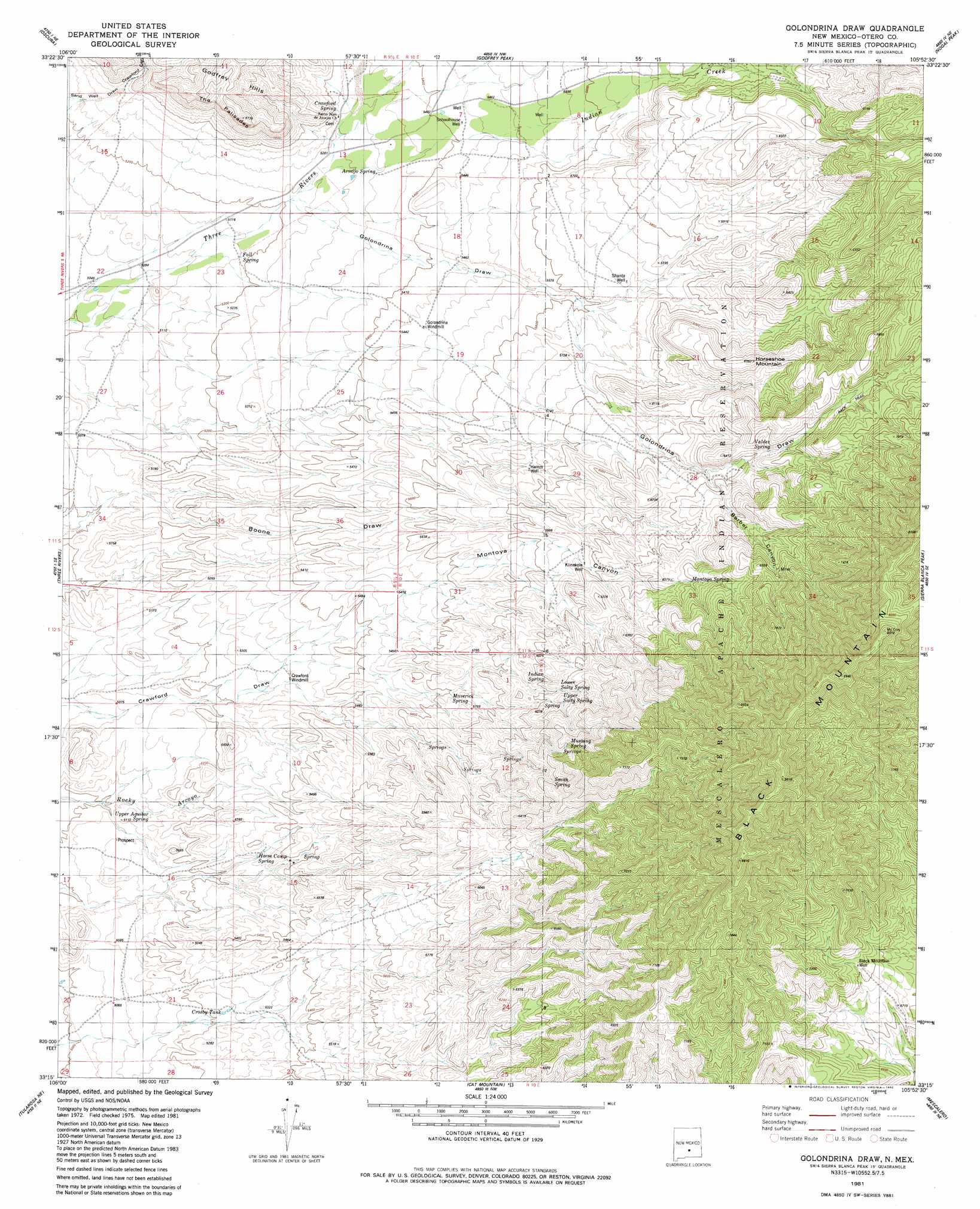
USGS Topo Quad 33105c8 - 1:24,000 scale
| Topo Map Name: | Golondrina Draw |
| USGS Topo Quad ID: | 33105c8 |
| Print Size: | ca. 21 1/4" wide x 27" high |
| Southeast Coordinates: | 33.25° N latitude / 105.875° W longitude |
| Map Center Coordinates: | 33.3125° N latitude / 105.9375° W longitude |
| U.S. State: | NM |
| Filename: | o33105c8.jpg |
| Download Map JPG Image: | Golondrina Draw topo map 1:24,000 scale |
| Map Type: | Topographic |
| Topo Series: | 7.5´ |
| Map Scale: | 1:24,000 |
| Source of Map Images: | United States Geological Survey (USGS) |
| Alternate Map Versions: |
Golondrina Draw NM 1981, updated 1982 Download PDF Buy paper map Golondrina Draw NM 2010 Download PDF Buy paper map Golondrina Draw NM 2013 Download PDF Buy paper map |
| FStopo: | US Forest Service topo Golondrina Draw is available: Download FStopo PDF Download FStopo TIF |
1:24,000 Topo Quads surrounding Golondrina Draw
Bull Gap Sw |
Bull Gap |
Cub Mountain |
Church Mountain |
Nogal |
Three Rivers Nw |
Oscura |
Godfrey Peak |
Nogal Peak |
Angus |
Three Rivers Sw |
Three Rivers |
Golondrina Draw |
Sierra Blanca Peak |
Ruidoso |
Bitter Creek |
Tularosa Ne |
Cat Mountain |
Mescalero |
Apache Summit |
Tularosa Peak |
Tularosa |
Sabinata Flat |
Domingo Peak |
Firman Canyon |
> Back to 33105a1 at 1:100,000 scale
> Back to 33104a1 at 1:250,000 scale
> Back to U.S. Topo Maps home
Golondrina Draw topo map: Gazetteer
Golondrina Draw: Cliffs
The Palisades elevation 1610m 5282′Golondrina Draw: Dams
A B Fall Dam and Aqueduct Historic Site elevation 1733m 5685′Golondrina Draw: Populated Places
Apache elevation 1886m 6187′Golondrina Draw: Post Offices
Apache Post Office (historical) elevation 1886m 6187′Golondrina Draw: Springs
Armijo Spring elevation 1622m 5321′Crawford Spring elevation 1639m 5377′
Crosby Spring elevation 1592m 5223′
Fall Spring elevation 1580m 5183′
Horse Camp Spring elevation 1613m 5291′
Indian Spring elevation 1605m 5265′
Lower Salty Spring elevation 1847m 6059′
Maverick Spring elevation 1720m 5643′
Montoya Spring elevation 1868m 6128′
Mustang Spring elevation 2506m 8221′
Smith Spring elevation 1940m 6364′
Upper Agular Spring elevation 1551m 5088′
Upper Salty Spring elevation 1852m 6076′
Valdez Spring elevation 1902m 6240′
Golondrina Draw: Streams
Indian Creek elevation 1596m 5236′Golondrina Draw: Summits
Black Mountain elevation 2576m 8451′Horse Mountain elevation 1922m 6305′
Golondrina Draw: Valleys
Barber Canyon elevation 1757m 5764′Crawford Canyon elevation 1632m 5354′
Golondrina Draw elevation 1587m 5206′
Montoya Canyon elevation 2058m 6751′
Three Rivers Canyon elevation 1605m 5265′
Golondrina Draw: Wells
Black Mountain Well elevation 2095m 6873′Hamm Well elevation 1745m 5725′
Klinekole Well elevation 2338m 7670′
Schoolhouse Well elevation 1652m 5419′
Shanta Well elevation 1733m 5685′
Golondrina Draw digital topo map on disk
Buy this Golondrina Draw topo map showing relief, roads, GPS coordinates and other geographical features, as a high-resolution digital map file on DVD: