Capitan Pass Topo Map New Mexico
To zoom in, hover over the map of Capitan Pass
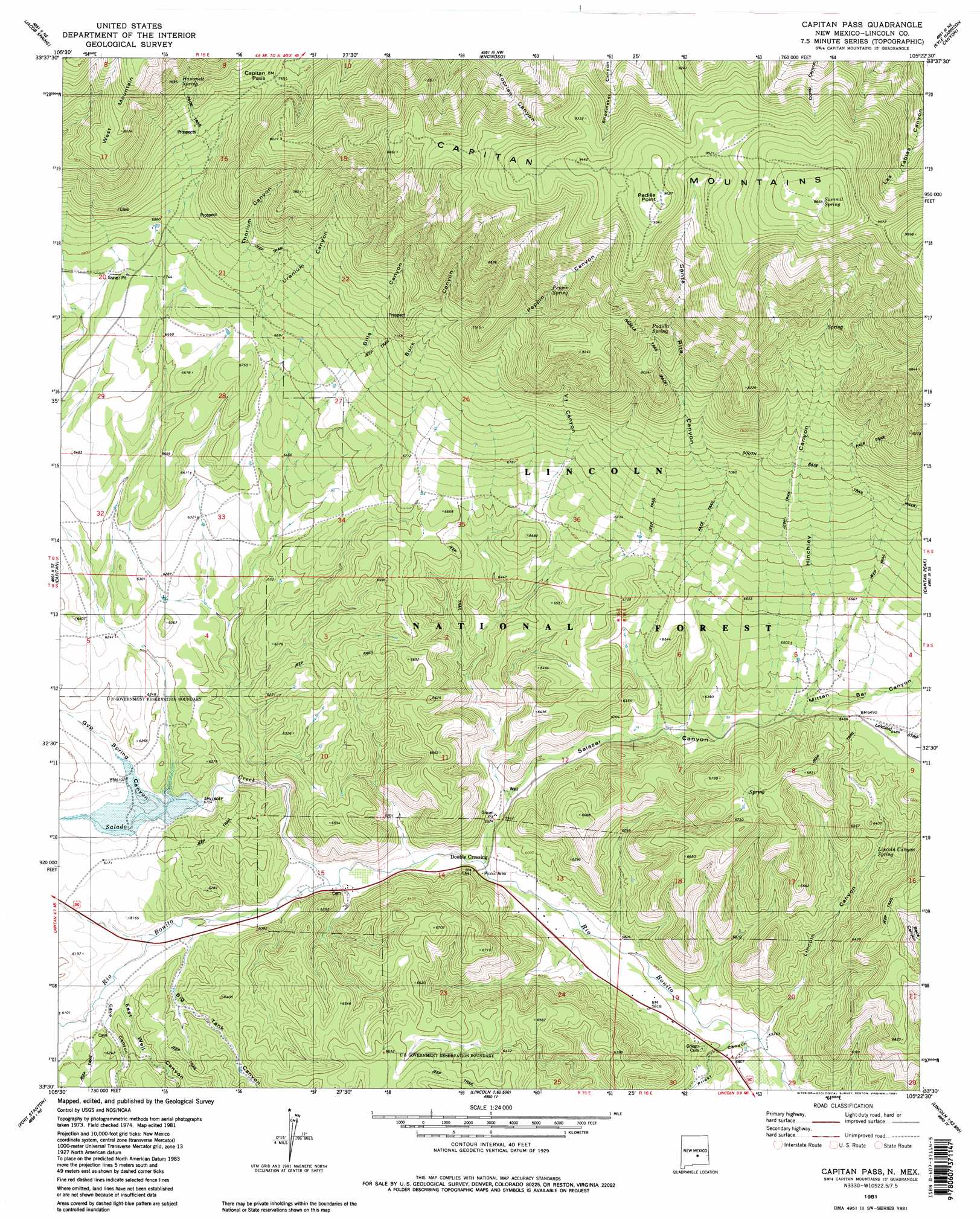
USGS Topo Quad 33105e4 - 1:24,000 scale
| Topo Map Name: | Capitan Pass |
| USGS Topo Quad ID: | 33105e4 |
| Print Size: | ca. 21 1/4" wide x 27" high |
| Southeast Coordinates: | 33.5° N latitude / 105.375° W longitude |
| Map Center Coordinates: | 33.5625° N latitude / 105.4375° W longitude |
| U.S. State: | NM |
| Filename: | o33105e4.jpg |
| Download Map JPG Image: | Capitan Pass topo map 1:24,000 scale |
| Map Type: | Topographic |
| Topo Series: | 7.5´ |
| Map Scale: | 1:24,000 |
| Source of Map Images: | United States Geological Survey (USGS) |
| Alternate Map Versions: |
Capitan Pass NM 1981, updated 1981 Download PDF Buy paper map Capitan Pass NM 1981, updated 1981 Download PDF Buy paper map Capitan Pass NM 2004, updated 2006 Download PDF Buy paper map Capitan Pass NM 2011 Download PDF Buy paper map Capitan Pass NM 2013 Download PDF Buy paper map |
| FStopo: | US Forest Service topo Capitan Pass is available: Download FStopo PDF Download FStopo TIF |
1:24,000 Topo Quads surrounding Capitan Pass
White Oaks North |
Jicarilla Peak |
Box Lake |
Pedernal Arroyo |
Huff Hill |
White Oaks South |
Jacob Spring |
Encinoso |
Kyle Harrison Canyon |
Arroyo Serrano West |
Nogal |
Capitan |
Capitan Pass |
Capitan Peak |
Arabela |
Angus |
Fort Stanton |
Lincoln |
San Patricio |
Nelson Canyon West |
Ruidoso |
Ruidoso Downs |
Sheeppen Canyon |
Wahalee Canyon |
Tinnie |
> Back to 33105e1 at 1:100,000 scale
> Back to 33104a1 at 1:250,000 scale
> Back to U.S. Topo Maps home
Capitan Pass topo map: Gazetteer
Capitan Pass: Airports
G Bar F Ranch Airport elevation 1980m 6496′Capitan Pass: Dams
Upper Rio Hondo Site One Dam elevation 1869m 6131′Capitan Pass: Gaps
Capitan Pass elevation 2265m 7431′Capitan Pass: Mines
Abo elevation 2186m 7171′Barlejon Number Two elevation 2229m 7312′
Barry Prospect elevation 2567m 8421′
Drunzer Prospect elevation 2304m 7559′
Hopeful Claims Number 1-19 elevation 2450m 8038′
King Prospect elevation 2430m 7972′
Monzo Claims elevation 2192m 7191′
Oso elevation 1945m 6381′
Pinie Claims elevation 2667m 8750′
Salazar Canyon Pit elevation 1827m 5994′
Silverstone Claim elevation 2192m 7191′
Wee Three Number 1 Mine elevation 2192m 7191′
Wee Three Number 2 Mine elevation 2192m 7191′
Yellow Hand elevation 2040m 6692′
Capitan Pass: Populated Places
Double Crossing elevation 1801m 5908′Capitan Pass: Reservoirs
Bear Trick Tank elevation 2848m 9343′Hinchley Bowl elevation 2030m 6660′
Lost Tank elevation 1912m 6272′
Norhteast Tank elevation 1926m 6318′
Northwest Tank elevation 1901m 6236′
Padilla Tank elevation 1958m 6423′
Padilla Trick Tank elevation 2920m 9580′
Salado Tank elevation 1907m 6256′
Section 10 Tank elevation 1901m 6236′
Southeast Tank elevation 1932m 6338′
Southwest 1 Tank elevation 1936m 6351′
Southwest 2 Tank elevation 1983m 6505′
Capitan Pass: Springs
Hammett Spring elevation 2357m 7732′Lincoln Canyon Spring elevation 1874m 6148′
Lower Padilla Spring elevation 2193m 7194′
Padilla Spring elevation 2571m 8435′
Peppin Spring elevation 2446m 8024′
Summit Spring elevation 3013m 9885′
Upper Padilla Spring elevation 2857m 9373′
Capitan Pass: Streams
Salado Creek elevation 1810m 5938′Capitan Pass: Summits
Padilla Point elevation 2929m 9609′Capitan Pass: Trails
Base Trail elevation 2198m 7211′Padilla Trail elevation 2406m 7893′
Padilla Trail elevation 2876m 9435′
Summit Trail elevation 2698m 8851′
Capitan Pass: Valleys
Big Tank Canyon elevation 1853m 6079′Bills Canyon elevation 2016m 6614′
Buck Canyon elevation 1957m 6420′
Cave Canyon elevation 1877m 6158′
East Well Canyon elevation 1854m 6082′
Gyp Spring Canyon elevation 1856m 6089′
Hinchley Canyon elevation 1926m 6318′
Lincoln Canyon elevation 1751m 5744′
Mitten Bar Canyon elevation 1926m 6318′
Peppin Canyon elevation 2007m 6584′
Priest Canyon elevation 1778m 5833′
Salazar Canyon elevation 1793m 5882′
Santa Rita Canyon elevation 2096m 6876′
Thorium Canyon elevation 2054m 6738′
Uranium Canyon elevation 2054m 6738′
Vl Canyon elevation 2023m 6637′
Capitan Pass: Wells
10192 Water Well elevation 1817m 5961′Capitan Pass digital topo map on disk
Buy this Capitan Pass topo map showing relief, roads, GPS coordinates and other geographical features, as a high-resolution digital map file on DVD: