Church Mountain Topo Map New Mexico
To zoom in, hover over the map of Church Mountain
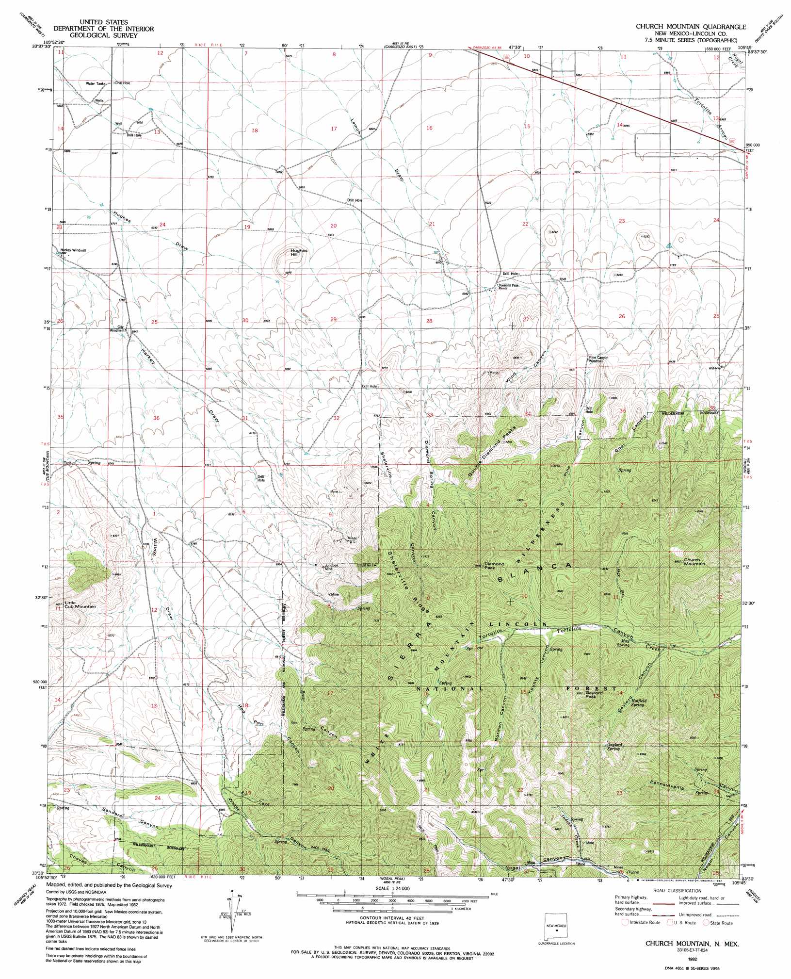
USGS Topo Quad 33105e7 - 1:24,000 scale
| Topo Map Name: | Church Mountain |
| USGS Topo Quad ID: | 33105e7 |
| Print Size: | ca. 21 1/4" wide x 27" high |
| Southeast Coordinates: | 33.5° N latitude / 105.75° W longitude |
| Map Center Coordinates: | 33.5625° N latitude / 105.8125° W longitude |
| U.S. State: | NM |
| Filename: | o33105e7.jpg |
| Download Map JPG Image: | Church Mountain topo map 1:24,000 scale |
| Map Type: | Topographic |
| Topo Series: | 7.5´ |
| Map Scale: | 1:24,000 |
| Source of Map Images: | United States Geological Survey (USGS) |
| Alternate Map Versions: |
Church Mountain NM 1982, updated 1982 Download PDF Buy paper map Church Mountain NM 1982, updated 1992 Download PDF Buy paper map Church Mountain NM 2004, updated 2006 Download PDF Buy paper map Church Mountain NM 2011 Download PDF Buy paper map Church Mountain NM 2013 Download PDF Buy paper map |
| FStopo: | US Forest Service topo Church Mountain is available: Download FStopo PDF Download FStopo TIF |
1:24,000 Topo Quads surrounding Church Mountain
Broken Back Crater |
Little Black Peak |
Lone Mountain |
White Oaks North |
Jicarilla Peak |
Wagon Canyon |
Carrizoza West |
Carrizoza East |
White Oaks South |
Jacob Spring |
Bull Gap |
Cub Mountain |
Church Mountain |
Nogal |
Capitan |
Oscura |
Godfrey Peak |
Nogal Peak |
Angus |
Fort Stanton |
Three Rivers |
Golondrina Draw |
Sierra Blanca Peak |
Ruidoso |
Ruidoso Downs |
> Back to 33105e1 at 1:100,000 scale
> Back to 33104a1 at 1:250,000 scale
> Back to U.S. Topo Maps home
Church Mountain topo map: Gazetteer
Church Mountain: Mines
Ball Hornet Claims elevation 2699m 8854′Betty and Stella Claims elevation 2177m 7142′
Bornite Mine elevation 2253m 7391′
Bull Dyker Mine elevation 2177m 7142′
Buster Brown Mine elevation 2061m 6761′
Butcher Boy elevation 2063m 6768′
C and M Number One and Two Claims elevation 2567m 8421′
Cap Claim elevation 2177m 7142′
Cinnamon Mine elevation 2253m 7391′
Clipper Claims elevation 2420m 7939′
Columbia Mine elevation 2121m 6958′
Commercial Mine elevation 2092m 6863′
Copper Glance Claim elevation 2141m 7024′
Copper Matte Claim elevation 2255m 7398′
Couger Mine elevation 2555m 8382′
D and B Tunnel elevation 2405m 7890′
Delaware Mine elevation 2253m 7391′
Grub Stake Mine elevation 2061m 6761′
Harry Allen Mine elevation 2177m 7142′
Hart Prospect elevation 2536m 8320′
Hat Claim elevation 2177m 7142′
Homestake Mine elevation 1982m 6502′
Homesteak Claim elevation 2239m 7345′
Idaho MIne elevation 2274m 7460′
Illinois Mine elevation 2629m 8625′
Iron Blossom elevation 2125m 6971′
Junction Mine elevation 2088m 6850′
Last Chance Claim Number 1 elevation 2699m 8854′
Little Hecla Claims elevation 2173m 7129′
Magma Number 1 and 2 Claims elevation 2043m 6702′
Midnight Mine elevation 2629m 8625′
Minnie Lea Mine elevation 2177m 7142′
Moscow Mine elevation 2061m 6761′
New Mexico Copper Corp Claims elevation 2388m 7834′
Park Gold Number 3 Mine elevation 2504m 8215′
Park Gold Tunnel elevation 2515m 8251′
Privateer Mine elevation 2253m 7391′
R and L Claim elevation 2564m 8412′
Red Jim Mine elevation 2253m 7391′
Richardson Claims elevation 2496m 8188′
Rochford Claims elevation 2420m 7939′
Sailor Boy Mine elevation 2061m 6761′
Silver Dollar Claim elevation 2141m 7024′
Silver-Copper Claim elevation 2177m 7142′
Sugar Stake Claim elevation 2311m 7582′
Surprise Contact Claim elevation 2312m 7585′
Surprise Mine elevation 2388m 7834′
Sylvanite Mine elevation 2043m 6702′
Telluride Mine elevation 2043m 6702′
Trust Mine elevation 2253m 7391′
Union Jack Mine elevation 2253m 7391′
Church Mountain: Ridges
Shelerville Ridge elevation 2399m 7870′Church Mountain: Springs
Gaylord Spring elevation 2391m 7844′Hatfield Spring elevation 2295m 7529′
May Spring elevation 2208m 7244′
Tortolita Spring elevation 2347m 7700′
Church Mountain: Streams
Indian Creek elevation 2487m 8159′Church Mountain: Summits
Church Mountain elevation 2662m 8733′Diamond Peak elevation 2576m 8451′
Double Diamond Peaks elevation 2187m 7175′
Gaylord Peak elevation 2640m 8661′
Hughes Hill elevation 1837m 6026′
Little Cub Mountain elevation 2139m 7017′
Church Mountain: Trails
Oakridge Trail elevation 2564m 8412′Pennsylvania Trail elevation 2739m 8986′
Church Mountain: Valleys
Bear Canyon elevation 2061m 6761′Diamond Spring Canyon elevation 1891m 6204′
Gaylord Canyon elevation 2180m 7152′
Goat Canyon elevation 1928m 6325′
Hog Pen Canyon elevation 1984m 6509′
Kountz Canyon elevation 2552m 8372′
Norman Canyon elevation 2330m 7644′
Pine Canyon elevation 1928m 6325′
Water Canyon elevation 2061m 6761′
Wind Canyon elevation 1918m 6292′
Church Mountain: Wells
10079 Water Well elevation 1736m 5695′Church Mountain digital topo map on disk
Buy this Church Mountain topo map showing relief, roads, GPS coordinates and other geographical features, as a high-resolution digital map file on DVD: