Cub Mountain Topo Map New Mexico
To zoom in, hover over the map of Cub Mountain
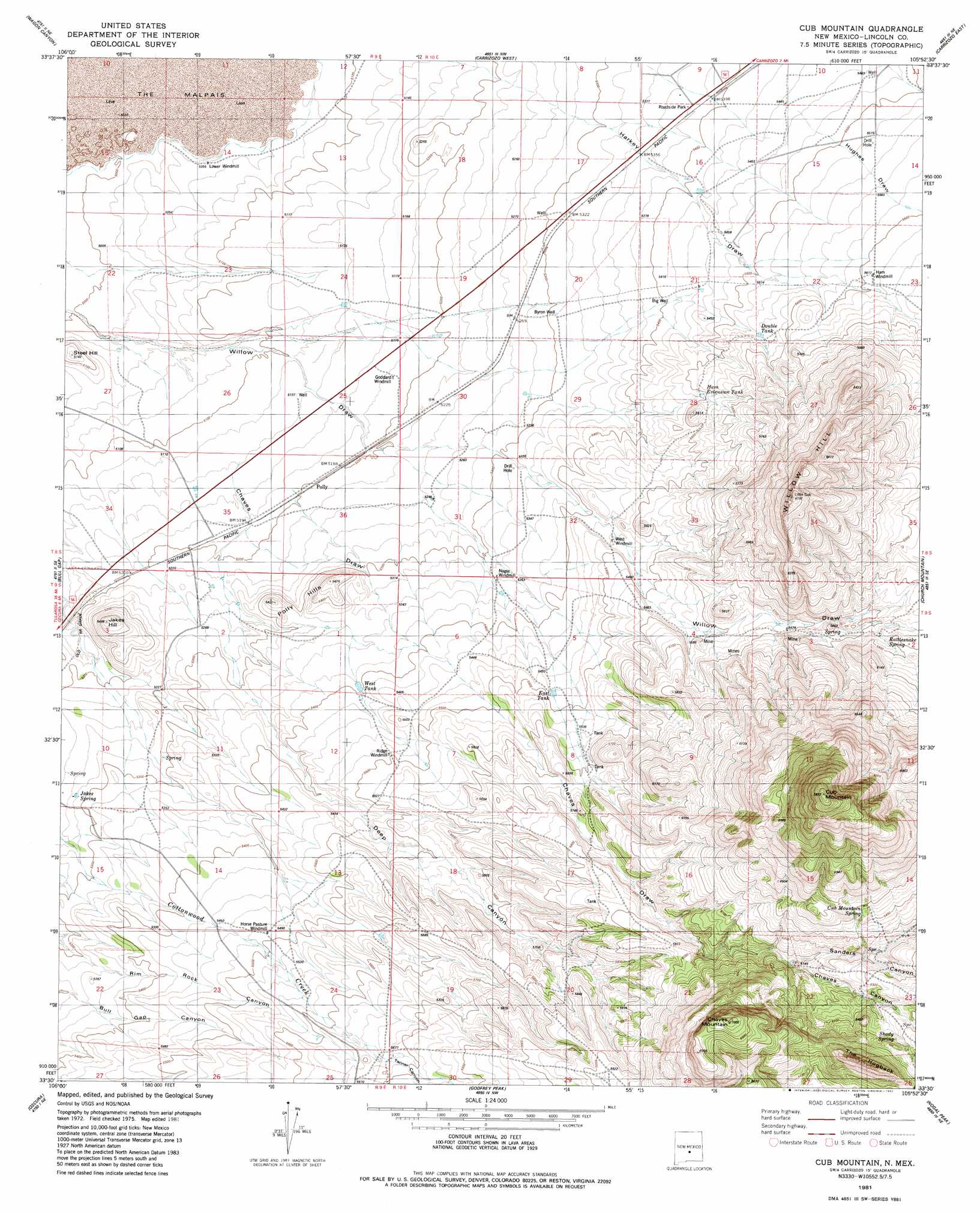
USGS Topo Quad 33105e8 - 1:24,000 scale
| Topo Map Name: | Cub Mountain |
| USGS Topo Quad ID: | 33105e8 |
| Print Size: | ca. 21 1/4" wide x 27" high |
| Southeast Coordinates: | 33.5° N latitude / 105.875° W longitude |
| Map Center Coordinates: | 33.5625° N latitude / 105.9375° W longitude |
| U.S. State: | NM |
| Filename: | o33105e8.jpg |
| Download Map JPG Image: | Cub Mountain topo map 1:24,000 scale |
| Map Type: | Topographic |
| Topo Series: | 7.5´ |
| Map Scale: | 1:24,000 |
| Source of Map Images: | United States Geological Survey (USGS) |
| Alternate Map Versions: |
Cub Mountain NM 1981, updated 1982 Download PDF Buy paper map Cub Mountain NM 2010 Download PDF Buy paper map Cub Mountain NM 2013 Download PDF Buy paper map |
| FStopo: | US Forest Service topo Cub Mountain is available: Download FStopo PDF Download FStopo TIF |
1:24,000 Topo Quads surrounding Cub Mountain
Pink Peak |
Broken Back Crater |
Little Black Peak |
Lone Mountain |
White Oaks North |
Red Canyon |
Wagon Canyon |
Carrizoza West |
Carrizoza East |
White Oaks South |
Bull Gap Sw |
Bull Gap |
Cub Mountain |
Church Mountain |
Nogal |
Three Rivers Nw |
Oscura |
Godfrey Peak |
Nogal Peak |
Angus |
Three Rivers Sw |
Three Rivers |
Golondrina Draw |
Sierra Blanca Peak |
Ruidoso |
> Back to 33105e1 at 1:100,000 scale
> Back to 33104a1 at 1:250,000 scale
> Back to U.S. Topo Maps home
Cub Mountain topo map: Gazetteer
Cub Mountain: Arroyos
Hughs Draw elevation 1665m 5462′Cub Mountain: Mines
Willow Springs elevation 1750m 5741′Cub Mountain: Populated Places
Polly elevation 1587m 5206′Cub Mountain: Reservoirs
Double Tank elevation 1692m 5551′East Tank elevation 1773m 5816′
Ham Extension Tank elevation 1679m 5508′
West Tank elevation 1646m 5400′
Cub Mountain: Ridges
The Hogback elevation 2079m 6820′Cub Mountain: Springs
Cub Mountain Spring elevation 1677m 5501′Jakes Spring elevation 1612m 5288′
Rattlesnake Spring elevation 1783m 5849′
Shady Spring elevation 1933m 6341′
Cub Mountain: Summits
Chaves Mountain elevation 2135m 7004′Cub Mountain elevation 2391m 7844′
Jakes Hill elevation 1663m 5456′
Polly Hills elevation 1641m 5383′
Steel Hill elevation 1565m 5134′
Willow Hill elevation 2053m 6735′
Cub Mountain: Valleys
Chaves Canyon elevation 1856m 6089′Chaves Draw elevation 1545m 5068′
Deep Canyon elevation 1583m 5193′
Sanders Canyon elevation 1856m 6089′
Shelerville Canyon elevation 1666m 5465′
Spring Canyon elevation 1754m 5754′
Cub Mountain: Wells
Byron Well elevation 1618m 5308′Cub Mountain digital topo map on disk
Buy this Cub Mountain topo map showing relief, roads, GPS coordinates and other geographical features, as a high-resolution digital map file on DVD: