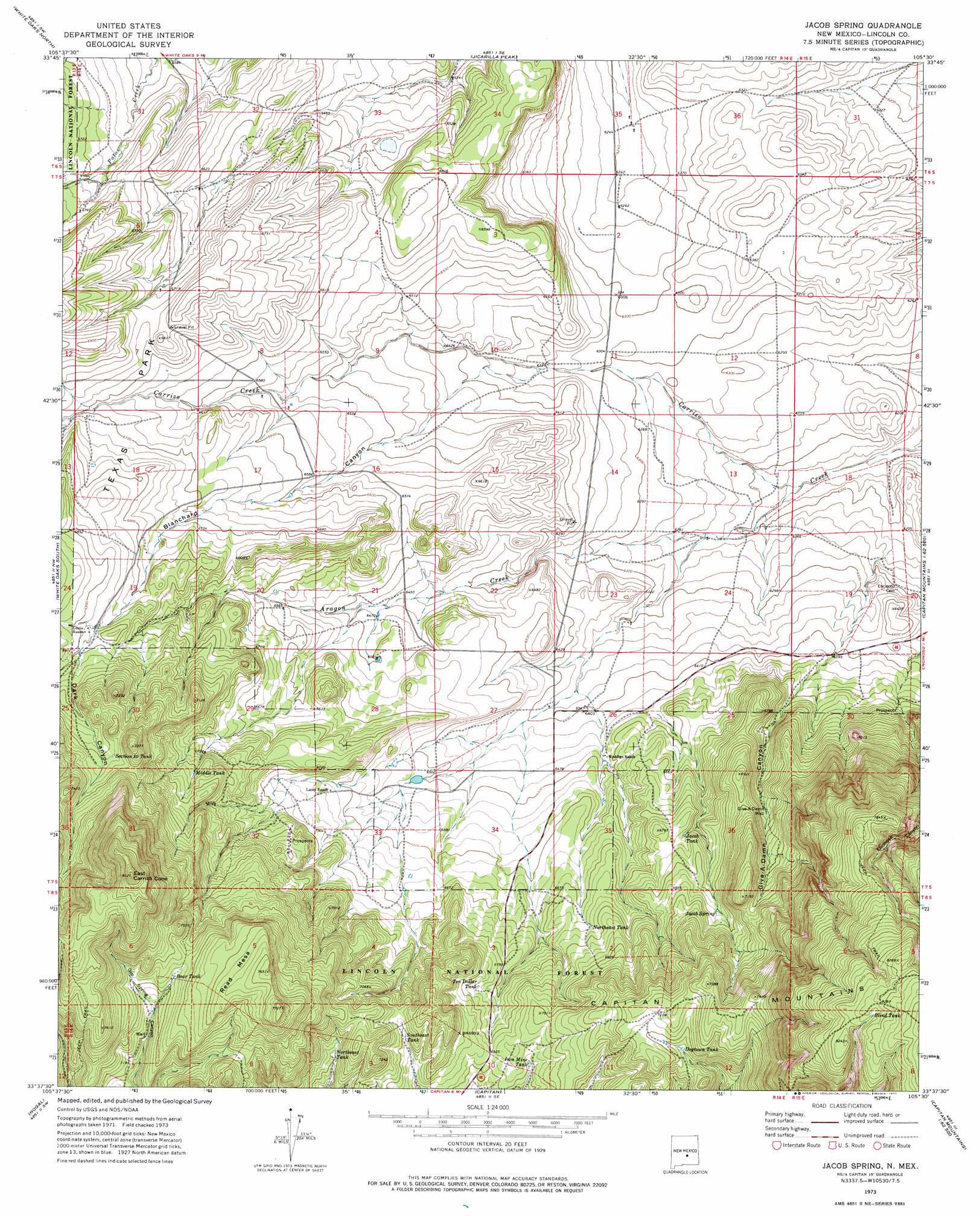
Jacob Spring Topo Map New Mexico
To zoom in, hover over the map of Jacob Spring
USGS Topo Quad 33105f5 - 1:24,000 scale
| Topo Map Name: | Jacob Spring |
| USGS Topo Quad ID: | 33105f5 |
| Print Size: | ca. 21 1/4" wide x 27" high |
| Southeast Coordinates: | 33.625° N latitude / 105.5° W longitude |
| Map Center Coordinates: | 33.6875° N latitude / 105.5625° W longitude |
| U.S. State: | NM |
| Filename: | o33105f5.jpg |
| Download Map JPG Image: | Jacob Spring topo map 1:24,000 scale |
| Map Type: | Topographic |
| Topo Series: | 7.5´ |
| Map Scale: | 1:24,000 |
| Source of Map Images: | United States Geological Survey (USGS) |
| Alternate Map Versions: |
Jacob Spring NM 1973, updated 1977 Download PDF Buy paper map Jacob Spring NM 2004, updated 2006 Download PDF Buy paper map Jacob Spring NM 2011 Download PDF Buy paper map Jacob Spring NM 2013 Download PDF Buy paper map |
| FStopo: | US Forest Service topo Jacob Spring is available: Download FStopo PDF Download FStopo TIF |
1:24,000 Topo Quads surrounding Jacob Spring
Little Black Peak Ne |
Ancho |
Chupadero Mountain |
Hasperos Camp |
Golondrina Well |
Lone Mountain |
White Oaks North |
Jicarilla Peak |
Box Lake |
Pedernal Arroyo |
Carrizoza East |
White Oaks South |
Jacob Spring |
Encinoso |
Kyle Harrison Canyon |
Church Mountain |
Nogal |
Capitan |
Capitan Pass |
Capitan Peak |
Nogal Peak |
Angus |
Fort Stanton |
Lincoln |
San Patricio |
> Back to 33105e1 at 1:100,000 scale
> Back to 33104a1 at 1:250,000 scale
> Back to U.S. Topo Maps home
Jacob Spring topo map: Gazetteer
Jacob Spring: Areas
Texas Park elevation 2029m 6656′Jacob Spring: Mines
Big Ben elevation 2265m 7431′Broken Toe elevation 2005m 6578′
McCrory Prospect Sec 31 elevation 2372m 7782′
McCrory Prospect Sec 36 elevation 2169m 7116′
Whettige elevation 2013m 6604′
Jacob Spring: Reservoirs
Bear Tank elevation 2233m 7326′Blind Tank elevation 2515m 8251′
Dogtown Tank elevation 2179m 7148′
Iron Mine Tank elevation 2102m 6896′
Jacob Tank elevation 2049m 6722′
Middle Tank elevation 2109m 6919′
Northeast Tank elevation 2065m 6774′
Northeast Tank elevation 2135m 7004′
Section Thirty Tank elevation 2175m 7135′
Southeast Tank elevation 2128m 6981′
Ten Dollar Tank elevation 2087m 6847′
Jacob Spring: Springs
Jacob Spring elevation 2092m 6863′Jacob Spring: Streams
Aragon Creek elevation 1879m 6164′South Fork Aragon Creek elevation 1899m 6230′
Jacob Spring: Summits
East Carrizo Cone elevation 2460m 8070′Read Mesa elevation 2347m 7700′
Jacob Spring: Valleys
Blanchard Canyon elevation 1929m 6328′Dark Canyon elevation 2113m 6932′
Give-A-Damn Canyon elevation 1916m 6286′
Jacob Spring: Wells
Give-A-Damn Well elevation 2054m 6738′Jacob Spring digital topo map on disk
Buy this Jacob Spring topo map showing relief, roads, GPS coordinates and other geographical features, as a high-resolution digital map file on DVD: