Dulce Draw Topo Map New Mexico
To zoom in, hover over the map of Dulce Draw
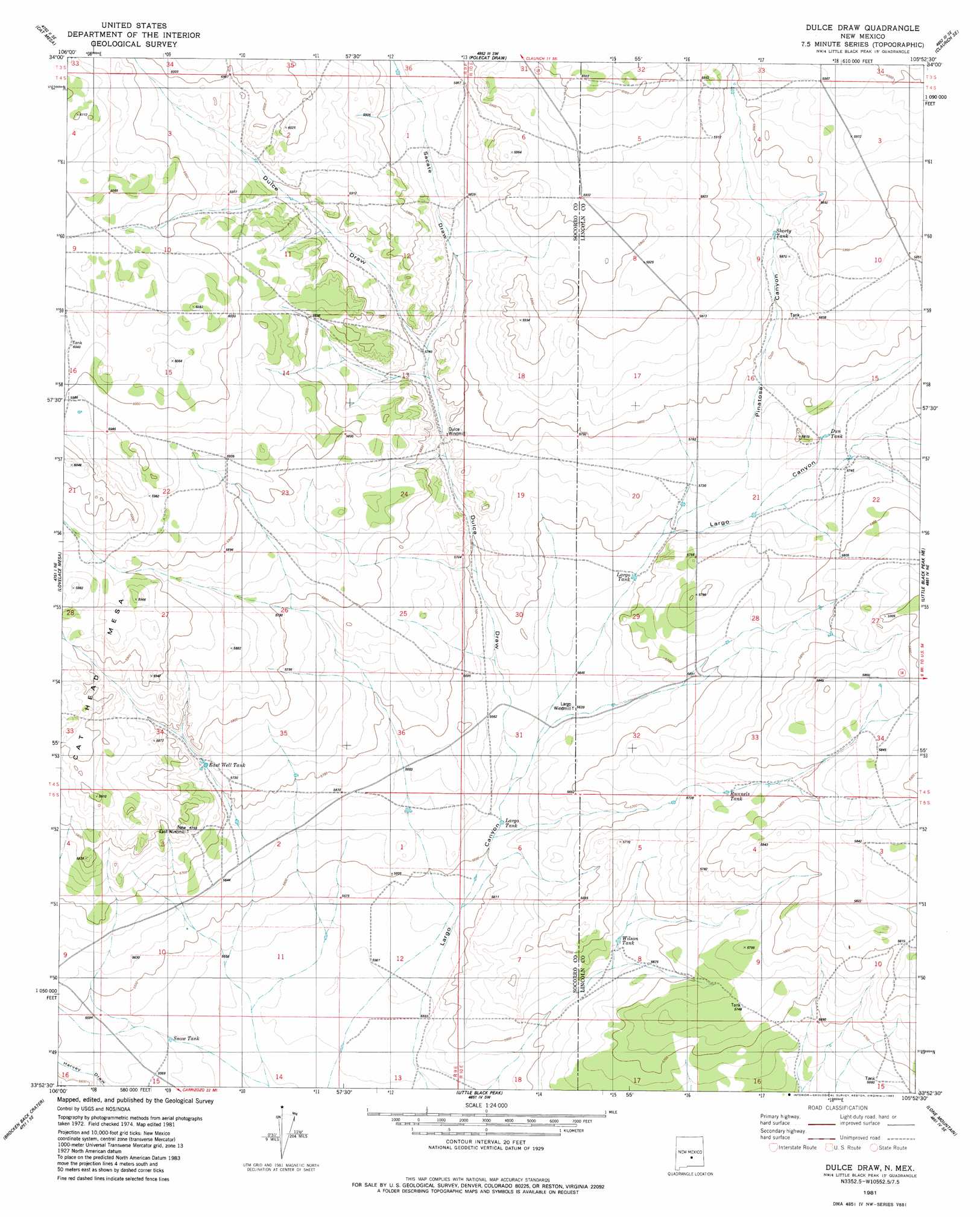
USGS Topo Quad 33105h8 - 1:24,000 scale
| Topo Map Name: | Dulce Draw |
| USGS Topo Quad ID: | 33105h8 |
| Print Size: | ca. 21 1/4" wide x 27" high |
| Southeast Coordinates: | 33.875° N latitude / 105.875° W longitude |
| Map Center Coordinates: | 33.9375° N latitude / 105.9375° W longitude |
| U.S. State: | NM |
| Filename: | o33105h8.jpg |
| Download Map JPG Image: | Dulce Draw topo map 1:24,000 scale |
| Map Type: | Topographic |
| Topo Series: | 7.5´ |
| Map Scale: | 1:24,000 |
| Source of Map Images: | United States Geological Survey (USGS) |
| Alternate Map Versions: |
Dulce Draw NM 1981, updated 1982 Download PDF Buy paper map Dulce Draw NM 2010 Download PDF Buy paper map Dulce Draw NM 2013 Download PDF Buy paper map |
1:24,000 Topo Quads surrounding Dulce Draw
Turkey Ridge |
Turkey Ridge Ne |
Claunch |
Pajaro Canyon |
Rough Mountain |
Turkey Ridge Sw |
Cat Mesa |
Polecat Draw |
Claunch Se |
Tecolote Peak |
Cooper Canyon |
Lovelace Mesa |
Dulce Draw |
Little Black Peak Ne |
Ancho |
Pink Peak |
Broken Back Crater |
Little Black Peak |
Lone Mountain |
White Oaks North |
Red Canyon |
Wagon Canyon |
Carrizoza West |
Carrizoza East |
White Oaks South |
> Back to 33105e1 at 1:100,000 scale
> Back to 33104a1 at 1:250,000 scale
> Back to U.S. Topo Maps home
Dulce Draw topo map: Gazetteer
Dulce Draw: Arroyos
Dulce Draw elevation 1740m 5708′Sacate Draw elevation 1760m 5774′
Dulce Draw: Reservoirs
Dun Tank elevation 1749m 5738′East Well Tank elevation 1747m 5731′
Largo Tank elevation 1740m 5708′
Largo Tank elevation 1733m 5685′
Runnels Tank elevation 1752m 5748′
Snow Tank elevation 1695m 5561′
Wilson Tank elevation 1726m 5662′
Dulce Draw: Summits
Cat Head Mesa elevation 1817m 5961′Dulce Draw: Valleys
Largo Canyon elevation 1689m 5541′Pinatosa Canyon elevation 1737m 5698′
Dulce Draw digital topo map on disk
Buy this Dulce Draw topo map showing relief, roads, GPS coordinates and other geographical features, as a high-resolution digital map file on DVD: