Hardscrabble Mountains Topo Map New Mexico
To zoom in, hover over the map of Hardscrabble Mountains
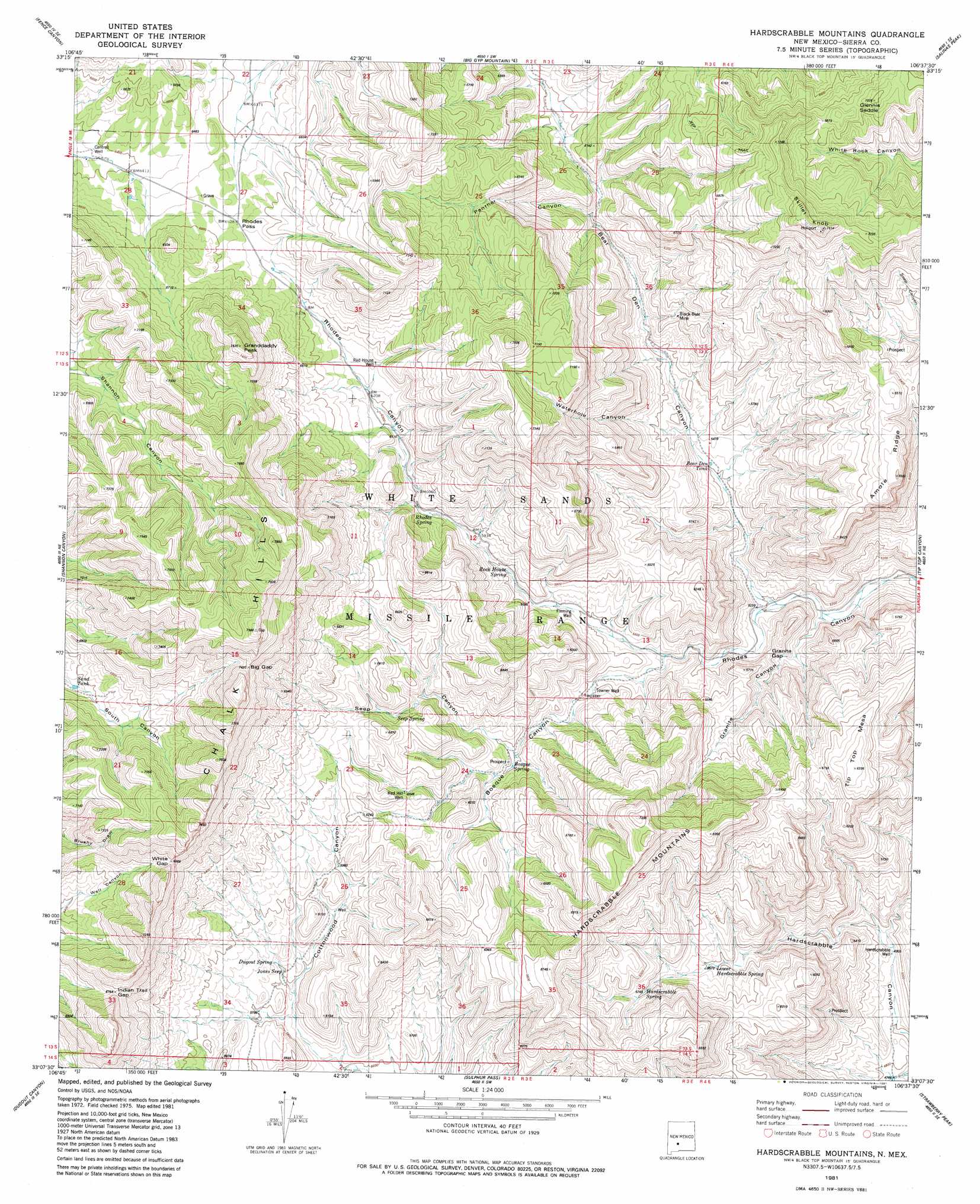
USGS Topo Quad 33106b6 - 1:24,000 scale
| Topo Map Name: | Hardscrabble Mountains |
| USGS Topo Quad ID: | 33106b6 |
| Print Size: | ca. 21 1/4" wide x 27" high |
| Southeast Coordinates: | 33.125° N latitude / 106.625° W longitude |
| Map Center Coordinates: | 33.1875° N latitude / 106.6875° W longitude |
| U.S. State: | NM |
| Filename: | o33106b6.jpg |
| Download Map JPG Image: | Hardscrabble Mountains topo map 1:24,000 scale |
| Map Type: | Topographic |
| Topo Series: | 7.5´ |
| Map Scale: | 1:24,000 |
| Source of Map Images: | United States Geological Survey (USGS) |
| Alternate Map Versions: |
Hardscrabble Mountains NM 1981, updated 1981 Download PDF Buy paper map Hardscrabble Mountains NM 1996, updated 2002 Download PDF Buy paper map Hardscrabble Mountains NM 2010 Download PDF Buy paper map Hardscrabble Mountains NM 2013 Download PDF Buy paper map Hardscrabble Mountains NM 2017 Download PDF Buy paper map |
1:24,000 Topo Quads surrounding Hardscrabble Mountains
Tucson Spring |
Fuller Ranch |
Salinas Peak Nw |
Fairview Mountain |
Capitol Peak |
Fairview Well |
Fence Canyon |
Big Gyp Mountain |
Salinas Peak |
Sheep Mountain |
Shannon Canyon Nw |
Shannon Canyon |
Hardscrabble Mountains |
Tip Top Canyon |
Lumley Lake Nw |
Polecat Tank |
Dugout Canyon |
Sulphur Pass |
Strawberry Peak |
Lumley Lake |
Prisor Hill |
Prisor Well |
Hembrillo Basin |
Hembrillo Canyon |
Heart Of The Sands Nw |
> Back to 33106a1 at 1:100,000 scale
> Back to 33106a1 at 1:250,000 scale
> Back to U.S. Topo Maps home
Hardscrabble Mountains topo map: Gazetteer
Hardscrabble Mountains: Gaps
Glennis Saddle elevation 2091m 6860′Granite Gap elevation 1626m 5334′
Indian Trail Gap elevation 2067m 6781′
Rhodes Pass elevation 1946m 6384′
Hardscrabble Mountains: Mines
Black Bear Mine elevation 1804m 5918′Hardscrabble Mountains: Ranges
Hardscrabble Mountains elevation 2203m 7227′Hardscrabble Mountains: Reservoirs
Bear Den Tank elevation 1649m 5410′Black Den Tank elevation 1710m 5610′
Hardscrabble Mountains: Ridges
Amole Ridge elevation 1986m 6515′Hardscrabble Mountains: Springs
Bear Den Spring elevation 1878m 6161′Bosque Spring elevation 1798m 5898′
Dugout Springs elevation 1785m 5856′
Hardscrabble Spring elevation 1794m 5885′
Jones Seep elevation 1768m 5800′
Lower Hardscrabble Spring elevation 1706m 5597′
Panther Seep elevation 1828m 5997′
Red House Well elevation 1921m 6302′
Rhodes Spring elevation 1841m 6040′
Rock House Spring elevation 1776m 5826′
Seep Springs elevation 1862m 6108′
Hardscrabble Mountains: Summits
Grandaddy Peak elevation 2286m 7500′Skillet Knob elevation 2305m 7562′
Tip Top Mesa elevation 1948m 6391′
Hardscrabble Mountains: Valleys
Bear Den Canyon elevation 1586m 5203′Bear Den Canyon elevation 1586m 5203′
Bosque Canyon elevation 1663m 5456′
Granite canyon elevation 1559m 5114′
Hardscrabble Canyon elevation 1465m 4806′
Panther Canyon elevation 2123m 6965′
Seep Canyon elevation 1756m 5761′
Waterhole Canyon elevation 1671m 5482′
Hardscrabble Mountains: Wells
Bear Den Well elevation 1810m 5938′Cantrell Well elevation 1943m 6374′
Fleming Well elevation 1714m 5623′
Hardscrabble Well elevation 1510m 4954′
Red Hill Well elevation 1867m 6125′
Towner Well elevation 1702m 5583′
Hardscrabble Mountains digital topo map on disk
Buy this Hardscrabble Mountains topo map showing relief, roads, GPS coordinates and other geographical features, as a high-resolution digital map file on DVD: