Lovelace Mesa Topo Map New Mexico
To zoom in, hover over the map of Lovelace Mesa
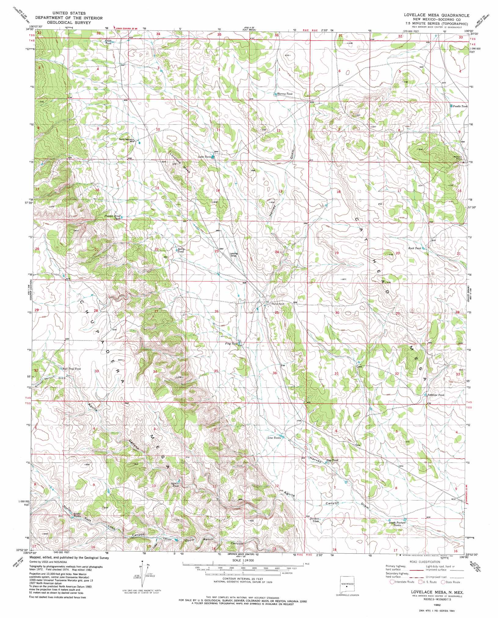
USGS Topo Quad 33106h1 - 1:24,000 scale
| Topo Map Name: | Lovelace Mesa |
| USGS Topo Quad ID: | 33106h1 |
| Print Size: | ca. 21 1/4" wide x 27" high |
| Southeast Coordinates: | 33.875° N latitude / 106° W longitude |
| Map Center Coordinates: | 33.9375° N latitude / 106.0625° W longitude |
| U.S. State: | NM |
| Filename: | o33106h1.jpg |
| Download Map JPG Image: | Lovelace Mesa topo map 1:24,000 scale |
| Map Type: | Topographic |
| Topo Series: | 7.5´ |
| Map Scale: | 1:24,000 |
| Source of Map Images: | United States Geological Survey (USGS) |
| Alternate Map Versions: |
Lovelace Mesa NM 1982, updated 1982 Download PDF Buy paper map Lovelace Mesa NM 2010 Download PDF Buy paper map Lovelace Mesa NM 2013 Download PDF Buy paper map Lovelace Mesa NM 2017 Download PDF Buy paper map |
1:24,000 Topo Quads surrounding Lovelace Mesa
Chupadera Spring |
Turkey Ridge |
Turkey Ridge Ne |
Claunch |
Pajaro Canyon |
Wilson Ranch |
Turkey Ridge Sw |
Cat Mesa |
Polecat Draw |
Claunch Se |
Wrye Peak |
Cooper Canyon |
Lovelace Mesa |
Dulce Draw |
Little Black Peak Ne |
Garden Spring Canyon |
Pink Peak |
Broken Back Crater |
Little Black Peak |
Lone Mountain |
Oscura Peak |
Red Canyon |
Wagon Canyon |
Carrizoza West |
Carrizoza East |
> Back to 33106e1 at 1:100,000 scale
> Back to 33106a1 at 1:250,000 scale
> Back to U.S. Topo Maps home
Lovelace Mesa topo map: Gazetteer
Lovelace Mesa: Arroyos
School Section Draw elevation 1893m 6210′Lovelace Mesa: Reservoirs
Aguila Tank elevation 1864m 6115′Antelope Tank elevation 1772m 5813′
Berry Tank elevation 1797m 5895′
Bull Trap Tank elevation 1898m 6227′
Dawson Tank elevation 1737m 5698′
Frog Tank elevation 1761m 5777′
Gyp Tank elevation 1736m 5695′
Harvey Tank elevation 1845m 6053′
Lake Tank elevation 1833m 6013′
Lake Tank elevation 1817m 5961′
Line Tanks elevation 1742m 5715′
Poodle Tank elevation 1837m 6026′
Powder River Tank elevation 1855m 6085′
Scotts Tanks elevation 1717m 5633′
South Pasture Tanks elevation 1717m 5633′
South Tank elevation 1855m 6085′
Lovelace Mesa: Summits
Lovelace Mesa elevation 1886m 6187′Lovelace Mesa: Valleys
Aguila Canyon elevation 1760m 5774′North Fork Lobo Canyon elevation 1845m 6053′
Lovelace Mesa: Wells
North Windmill elevation 1838m 6030′Lovelace Mesa digital topo map on disk
Buy this Lovelace Mesa topo map showing relief, roads, GPS coordinates and other geographical features, as a high-resolution digital map file on DVD: