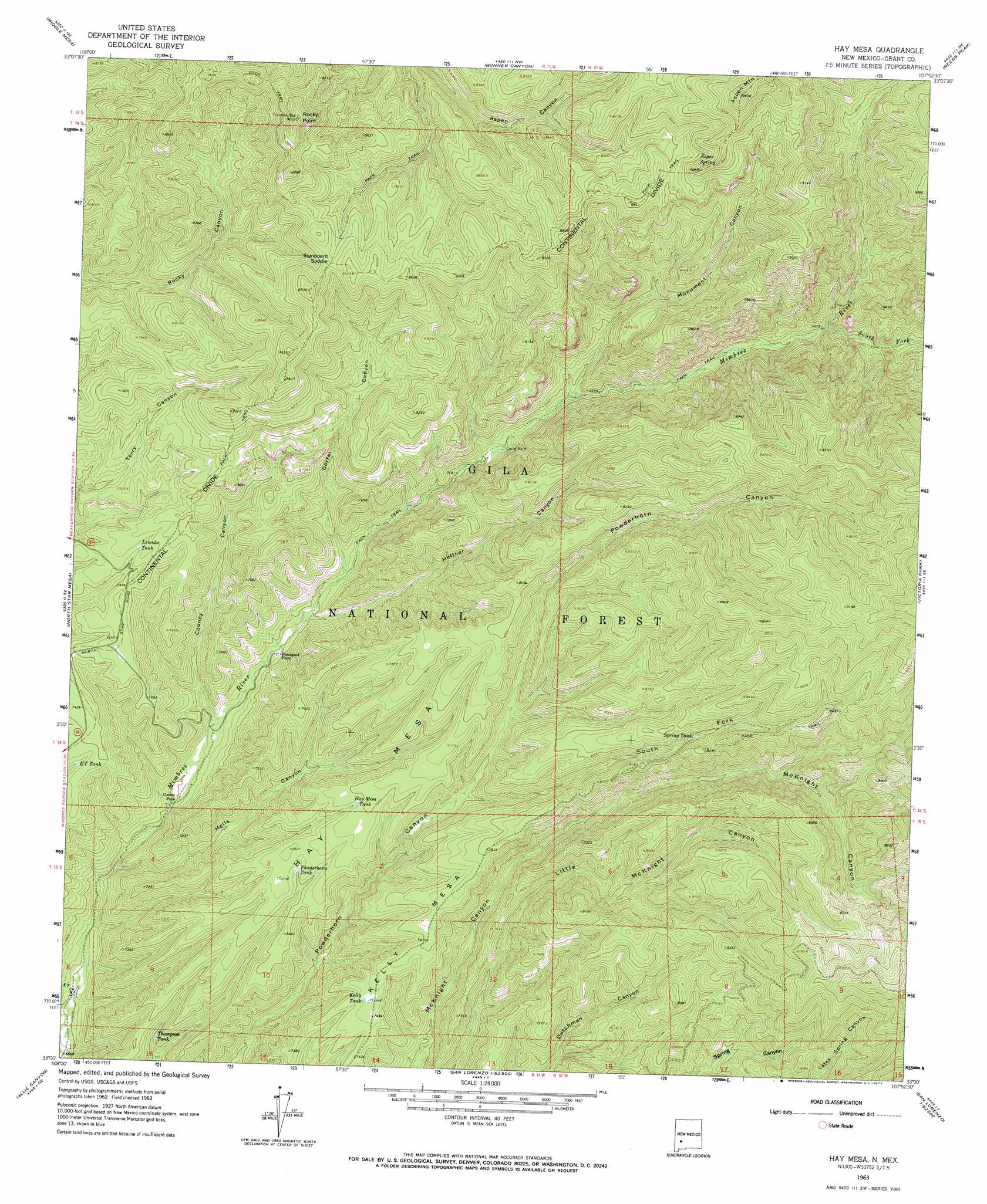
Hay Mesa Topo Map New Mexico
To zoom in, hover over the map of Hay Mesa
USGS Topo Quad 33107a8 - 1:24,000 scale
| Topo Map Name: | Hay Mesa |
| USGS Topo Quad ID: | 33107a8 |
| Print Size: | ca. 21 1/4" wide x 27" high |
| Southeast Coordinates: | 33° N latitude / 107.875° W longitude |
| Map Center Coordinates: | 33.0625° N latitude / 107.9375° W longitude |
| U.S. State: | NM |
| Filename: | o33107a8.jpg |
| Download Map JPG Image: | Hay Mesa topo map 1:24,000 scale |
| Map Type: | Topographic |
| Topo Series: | 7.5´ |
| Map Scale: | 1:24,000 |
| Source of Map Images: | United States Geological Survey (USGS) |
| Alternate Map Versions: |
Hay Mesa NM 1963, updated 1965 Download PDF Buy paper map Hay Mesa NM 1963, updated 1973 Download PDF Buy paper map Hay Mesa NM 1999, updated 2002 Download PDF Buy paper map Hay Mesa NM 2011 Download PDF Buy paper map Hay Mesa NM 2013 Download PDF Buy paper map Hay Mesa NM 2017 Download PDF Buy paper map |
| FStopo: | US Forest Service topo Hay Mesa is available: Download FStopo PDF Download FStopo TIF |
1:24,000 Topo Quads surrounding Hay Mesa
Burnt Corral Canyon |
Wall Lake |
Baily Points |
Lookout Mountain |
Winston |
Gila Hot Springs |
Middle Mesa |
Bonner Canyon |
Reeds Peak |
Sugarloaf Peak |
Copperas Peak |
North Star Mesa |
Hay Mesa |
Victoria Park |
Apache Peak |
Twin Sisters |
Allie Canyon |
Hendricks Peak |
Hillsboro Peak |
Kingston |
Fort Bayard |
Santa Rita |
San Lorenzo |
Maverick Mountain |
Pa Mountain |
> Back to 33107a1 at 1:100,000 scale
> Back to 33106a1 at 1:250,000 scale
> Back to U.S. Topo Maps home
Hay Mesa topo map: Gazetteer
Hay Mesa: Gaps
Signboard Saddle elevation 2589m 8494′Hay Mesa: Populated Places
Bloodgood Place elevation 2119m 6952′Hay Mesa: Reservoirs
E T Tank elevation 2220m 7283′Hay Mesa Tank elevation 2295m 7529′
Hay Number Two Tank elevation 2453m 8047′
Hay Tank elevation 2382m 7814′
Ingersoll Tank elevation 2127m 6978′
Kelly Tank elevation 2281m 7483′
Lincoln Tank elevation 2273m 7457′
Middle Tank elevation 2258m 7408′
North Tank elevation 2276m 7467′
Pit Tank elevation 2392m 7847′
Powderhorn Tank elevation 2264m 7427′
Spring Tank elevation 2421m 7942′
Thompson Tank elevation 2121m 6958′
Thompson Tank Number Twenty elevation 2093m 6866′
Hay Mesa: Ridges
Hay Mesa elevation 2335m 7660′Hay Mesa: Springs
Aspen Spring elevation 2675m 8776′Cabin Spring elevation 2245m 7365′
Monument Spring elevation 2509m 8231′
Outlaw Spring elevation 2632m 8635′
Yates Spring elevation 2388m 7834′
Hay Mesa: Streams
South Fork Mimbres River elevation 2339m 7673′Hay Mesa: Summits
Aspen Mountain elevation 2926m 9599′Kelly Mesa elevation 2311m 7582′
Rocky Point elevation 2744m 9002′
Hay Mesa: Valleys
Cooney Canyon elevation 2096m 6876′Corral Canyon elevation 2144m 7034′
E T Canyon elevation 2019m 6624′
Heffner Canyon elevation 2128m 6981′
Hells Canyon elevation 2059m 6755′
Monument Canyon elevation 2231m 7319′
North Fork McKnight Canyon elevation 2349m 7706′
South Fork Powderhorn Canyon elevation 2238m 7342′
Hay Mesa: Wells
Cabin Well elevation 2121m 6958′Mimbres Well elevation 2019m 6624′
Hay Mesa digital topo map on disk
Buy this Hay Mesa topo map showing relief, roads, GPS coordinates and other geographical features, as a high-resolution digital map file on DVD: