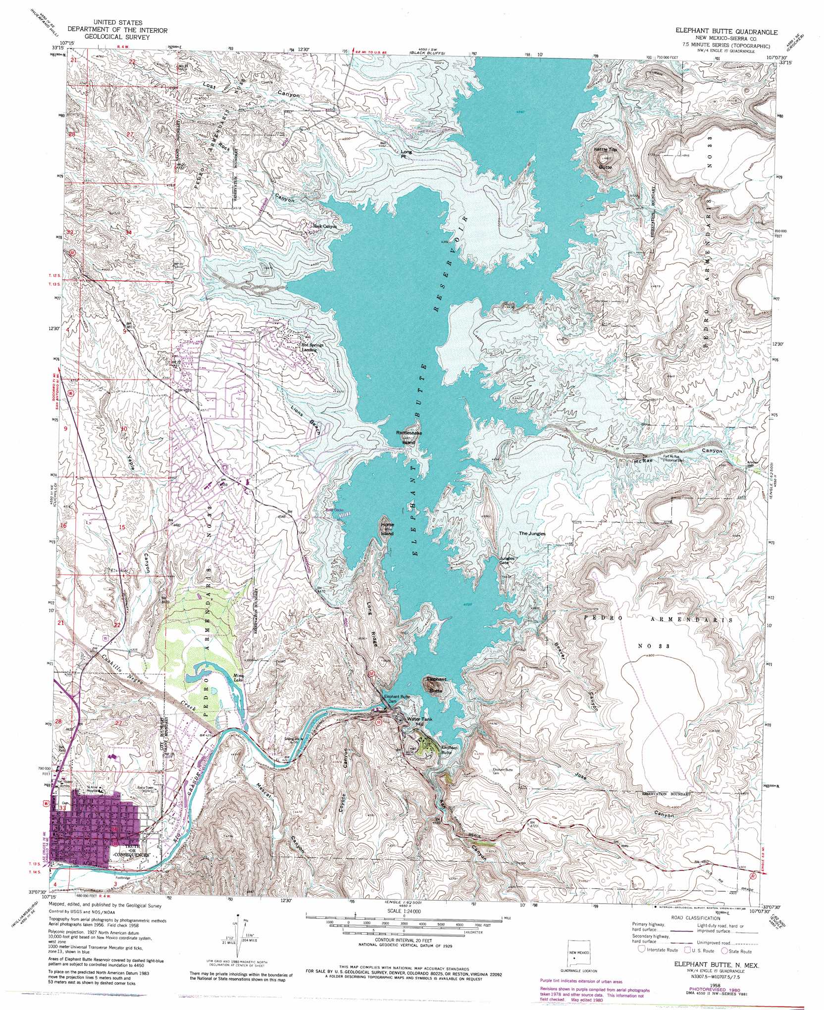
Elephant Butte Topo Map New Mexico
To zoom in, hover over the map of Elephant Butte
USGS Topo Quad 33107b2 - 1:24,000 scale
| Topo Map Name: | Elephant Butte |
| USGS Topo Quad ID: | 33107b2 |
| Print Size: | ca. 21 1/4" wide x 27" high |
| Southeast Coordinates: | 33.125° N latitude / 107.125° W longitude |
| Map Center Coordinates: | 33.1875° N latitude / 107.1875° W longitude |
| U.S. State: | NM |
| Filename: | o33107b2.jpg |
| Download Map JPG Image: | Elephant Butte topo map 1:24,000 scale |
| Map Type: | Topographic |
| Topo Series: | 7.5´ |
| Map Scale: | 1:24,000 |
| Source of Map Images: | United States Geological Survey (USGS) |
| Alternate Map Versions: |
Elephant Butte NM 1958, updated 1960 Download PDF Buy paper map Elephant Butte NM 1958, updated 1975 Download PDF Buy paper map Elephant Butte NM 1958, updated 1981 Download PDF Buy paper map Elephant Butte NM 1958, updated 1985 Download PDF Buy paper map Elephant Butte NM 2010 Download PDF Buy paper map Elephant Butte NM 2013 Download PDF Buy paper map Elephant Butte NM 2017 Download PDF Buy paper map |
1:24,000 Topo Quads surrounding Elephant Butte
Monticello |
Sierra Fijardo |
Romero Canyon |
Lava |
Tucson Spring |
Priest Tank |
Huerfano Hill |
Black Bluffs |
Crocker |
Fairview Well |
Williamsburg Nw |
Cuchillo |
Elephant Butte |
Engle |
Shannon Canyon Nw |
Saladone Tank |
Williamsburg |
Palomas Gap |
Cutter |
Polecat Tank |
Skute Stone Arroyo |
Caballo |
Apache Gap |
Upham |
Prisor Hill |
> Back to 33107a1 at 1:100,000 scale
> Back to 33106a1 at 1:250,000 scale
> Back to U.S. Topo Maps home
Elephant Butte topo map: Gazetteer
Elephant Butte: Airports
Sierra Vista Hospital Heliport elevation 1341m 4399′Elephant Butte: Beaches
Lions Beach elevation 1359m 4458′Elephant Butte: Capes
Long Point elevation 1357m 4452′Elephant Butte: Channels
Jungles Gate elevation 1327m 4353′Elephant Butte: Dams
Elephant Butte Dike elevation 1338m 4389′Elephant Butte: Islands
Horse Island elevation 1370m 4494′Rattlesnake Island elevation 1364m 4475′
Elephant Butte: Lakes
Mims Lake elevation 1297m 4255′Elephant Butte: Mines
Diamond A Ranch Mine elevation 1341m 4399′Ellis Deposit elevation 1306m 4284′
Sampson Mine elevation 1393m 4570′
Elephant Butte: Populated Places
Elephant Butte elevation 1361m 4465′Elephant Butte Estates elevation 1365m 4478′
Hot Springs Landing elevation 1371m 4498′
Rock Canyon elevation 1374m 4507′
Elephant Butte: Post Offices
Elephant Butte Post Office (historical) elevation 1361m 4465′Elephant Butte: Reservoirs
Elephant Butte Reservoir elevation 1314m 4311′Elephant Butte: Ridges
Long Ridge elevation 1422m 4665′Elephant Butte: Streams
Cuchillo Negro Creek elevation 1297m 4255′Elephant Butte: Summits
Elephant Butte elevation 1414m 4639′Kettle Top Butte elevation 1473m 4832′
Water Tank Hill elevation 1390m 4560′
Elephant Butte: Swamps
The Jungles elevation 1355m 4445′Elephant Butte: Valleys
Ash Canyon elevation 1359m 4458′Beaver Canyon elevation 1342m 4402′
Cedar Canyon elevation 1353m 4438′
Coyote Canyon elevation 1298m 4258′
Jose Canyon elevation 1335m 4379′
Lost Canyon elevation 1344m 4409′
McRae Canyon elevation 1327m 4353′
Mescal Canyon elevation 1298m 4258′
Rock Canyon elevation 1327m 4353′
Yaple Canyon elevation 1311m 4301′
Elephant Butte: Wells
RG 12459 Water Well elevation 1297m 4255′RG 13677 Water Well elevation 1324m 4343′
RG 13781 Water Well elevation 1346m 4416′
RG 15438 Water Well elevation 1304m 4278′
RG 16111 Water Well elevation 1323m 4340′
RG 16131 Water Well elevation 1392m 4566′
RG 16455 Water Well elevation 1297m 4255′
RG 1842 Water Well elevation 1298m 4258′
RG 23251 Water Well elevation 1319m 4327′
RG 23383 Water Well elevation 1375m 4511′
RG 23516 Water Well elevation 1369m 4491′
RG 23960 Water Well elevation 1361m 4465′
RG 28960 Water Well elevation 1323m 4340′
RG 30596 Water Well elevation 1336m 4383′
RG 3927 Water Well elevation 1350m 4429′
RG 4097 Water Well elevation 1327m 4353′
RG 4272 Water Well elevation 1391m 4563′
RG 4273 Water Well elevation 1361m 4465′
RG 4822 Water Well elevation 1314m 4311′
RG 7777 Water Well elevation 1297m 4255′
RG 8789 Water Well elevation 1377m 4517′
Elephant Butte digital topo map on disk
Buy this Elephant Butte topo map showing relief, roads, GPS coordinates and other geographical features, as a high-resolution digital map file on DVD: