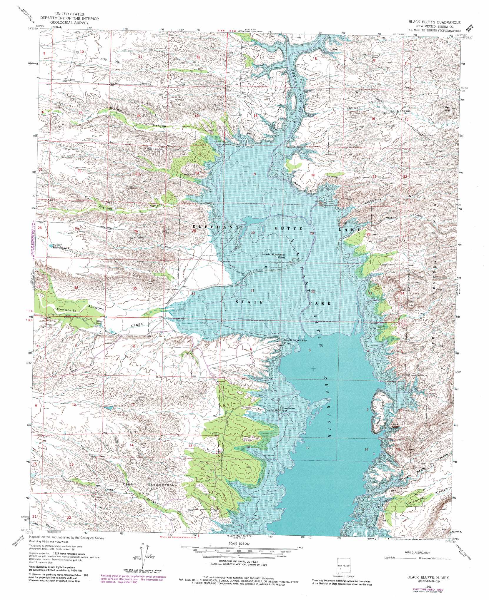
Black Bluffs Topo Map New Mexico
To zoom in, hover over the map of Black Bluffs
USGS Topo Quad 33107c2 - 1:24,000 scale
| Topo Map Name: | Black Bluffs |
| USGS Topo Quad ID: | 33107c2 |
| Print Size: | ca. 21 1/4" wide x 27" high |
| Southeast Coordinates: | 33.25° N latitude / 107.125° W longitude |
| Map Center Coordinates: | 33.3125° N latitude / 107.1875° W longitude |
| U.S. State: | NM |
| Filename: | o33107c2.jpg |
| Download Map JPG Image: | Black Bluffs topo map 1:24,000 scale |
| Map Type: | Topographic |
| Topo Series: | 7.5´ |
| Map Scale: | 1:24,000 |
| Source of Map Images: | United States Geological Survey (USGS) |
| Alternate Map Versions: |
Black Bluffs NM 1961, updated 1963 Download PDF Buy paper map Black Bluffs NM 1961, updated 1981 Download PDF Buy paper map Black Bluffs NM 1961, updated 1985 Download PDF Buy paper map Black Bluffs NM 1961, updated 1985 Download PDF Buy paper map Black Bluffs NM 2010 Download PDF Buy paper map Black Bluffs NM 2013 Download PDF Buy paper map Black Bluffs NM 2017 Download PDF Buy paper map |
1:24,000 Topo Quads surrounding Black Bluffs
Vicks Peak |
Steel Hill |
Black Hill |
Paraje Well |
Pope |
Monticello |
Sierra Fijardo |
Romero Canyon |
Lava |
Tucson Spring |
Priest Tank |
Huerfano Hill |
Black Bluffs |
Crocker |
Fairview Well |
Williamsburg Nw |
Cuchillo |
Elephant Butte |
Engle |
Shannon Canyon Nw |
Saladone Tank |
Williamsburg |
Palomas Gap |
Cutter |
Polecat Tank |
> Back to 33107a1 at 1:100,000 scale
> Back to 33106a1 at 1:250,000 scale
> Back to U.S. Topo Maps home
Black Bluffs topo map: Gazetteer
Black Bluffs: Capes
Black Bluffs elevation 1364m 4475′Mitchell Point elevation 1368m 4488′
North Monticello Point elevation 1345m 4412′
South Monticello Point elevation 1361m 4465′
Three Sisters Point elevation 1351m 4432′
Black Bluffs: Cliffs
Red Cliff elevation 1402m 4599′White Cliffs elevation 1360m 4461′
Black Bluffs: Mines
Bolander elevation 1357m 4452′Black Bluffs: Reservoirs
Blander Reservoir Number One elevation 1472m 4829′Black Bluffs: Slopes
Double Canyon elevation 1354m 4442′Black Bluffs: Streams
Alamosa Creek elevation 1355m 4445′Black Bluffs: Summits
Crater Hill elevation 1546m 5072′Black Bluffs: Valleys
Cottonwood Canyon elevation 1361m 4465′Flying Eagle Canyon elevation 1331m 4366′
Hackberry Canyon elevation 1346m 4416′
Hellion Canyon elevation 1346m 4416′
Mitchell Canyon elevation 1347m 4419′
Monticello Canyon elevation 1347m 4419′
Pinosa Canyon elevation 1346m 4416′
Reynolds Canyon elevation 1387m 4550′
Walnut Canyon elevation 1335m 4379′
Black Bluffs: Wells
Narrows Water Well elevation 1380m 4527′RG 4091 Water Well elevation 1358m 4455′
RG 6977 Water Well elevation 1375m 4511′
Black Bluffs digital topo map on disk
Buy this Black Bluffs topo map showing relief, roads, GPS coordinates and other geographical features, as a high-resolution digital map file on DVD: