Lookout Mountain Topo Map New Mexico
To zoom in, hover over the map of Lookout Mountain
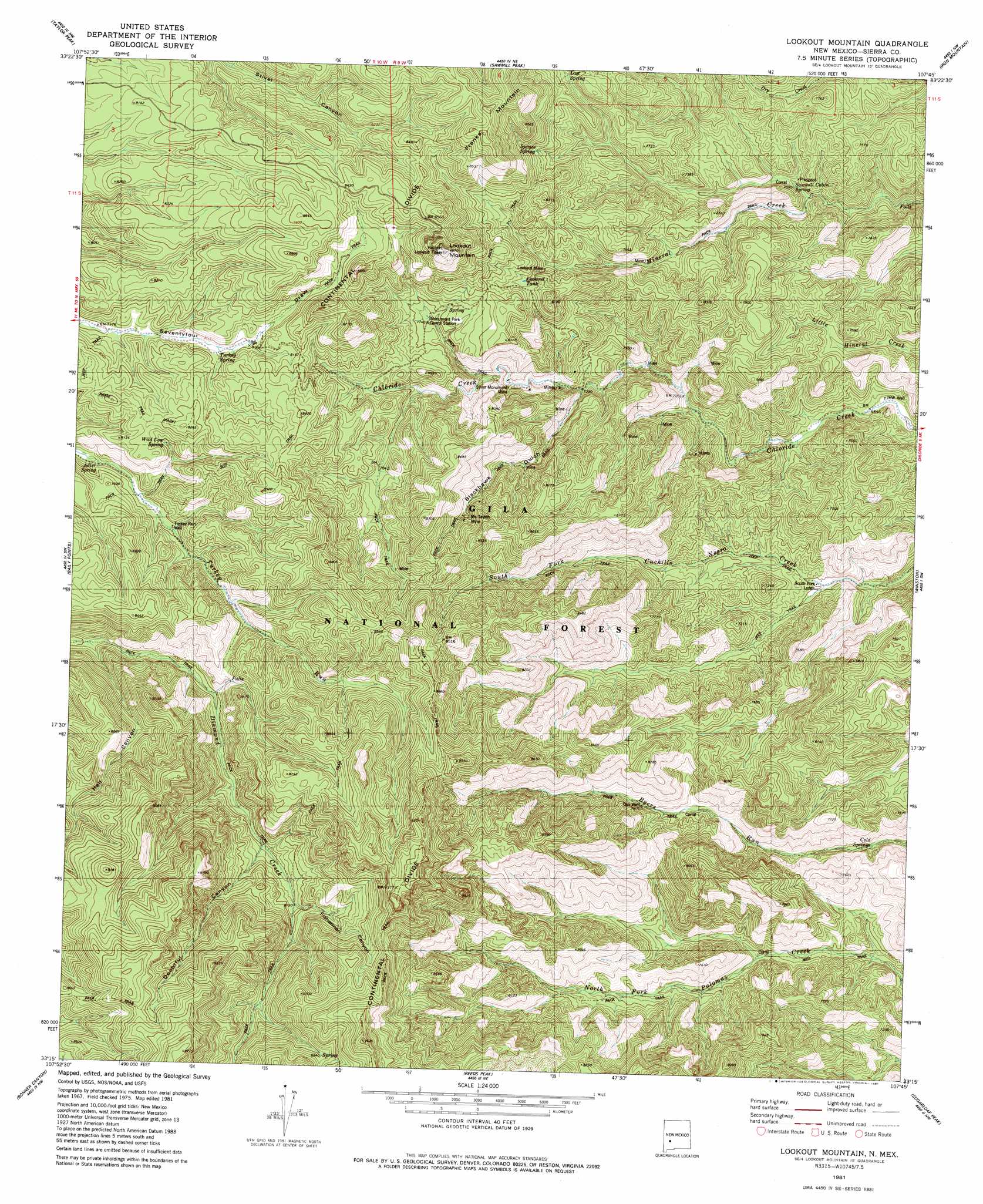
USGS Topo Quad 33107c7 - 1:24,000 scale
| Topo Map Name: | Lookout Mountain |
| USGS Topo Quad ID: | 33107c7 |
| Print Size: | ca. 21 1/4" wide x 27" high |
| Southeast Coordinates: | 33.25° N latitude / 107.75° W longitude |
| Map Center Coordinates: | 33.3125° N latitude / 107.8125° W longitude |
| U.S. State: | NM |
| Filename: | o33107c7.jpg |
| Download Map JPG Image: | Lookout Mountain topo map 1:24,000 scale |
| Map Type: | Topographic |
| Topo Series: | 7.5´ |
| Map Scale: | 1:24,000 |
| Source of Map Images: | United States Geological Survey (USGS) |
| Alternate Map Versions: |
Lookout Mountain NM 1981, updated 1981 Download PDF Buy paper map Lookout Mountain NM 1981, updated 1981 Download PDF Buy paper map Lookout Mountain NM 1999, updated 2002 Download PDF Buy paper map Lookout Mountain NM 2011 Download PDF Buy paper map Lookout Mountain NM 2013 Download PDF Buy paper map Lookout Mountain NM 2017 Download PDF Buy paper map |
| FStopo: | US Forest Service topo Lookout Mountain is available: Download FStopo PDF Download FStopo TIF |
1:24,000 Topo Quads surrounding Lookout Mountain
Indian Peaks West |
Indian Peaks East |
Wahoo Peak |
Wahoo Ranch |
Montoya Butte |
Spring Canyon |
Taylor Peak |
Sawmill Peak |
Iron Mountain |
Jaralosa Mountain |
Wall Lake |
Baily Points |
Lookout Mountain |
Winston |
Chise |
Middle Mesa |
Bonner Canyon |
Reeds Peak |
Sugarloaf Peak |
Thumb Tank Peak |
North Star Mesa |
Hay Mesa |
Victoria Park |
Apache Peak |
Bell Mountain |
> Back to 33107a1 at 1:100,000 scale
> Back to 33106a1 at 1:250,000 scale
> Back to U.S. Topo Maps home
Lookout Mountain topo map: Gazetteer
Lookout Mountain: Mines
Lookout Mine elevation 2353m 7719′McTavish Mine elevation 2427m 7962′
New Era elevation 2474m 8116′
Silver Bar Mine elevation 2166m 7106′
Silver Glance Mine elevation 2248m 7375′
Silver Monument Mine elevation 2230m 7316′
Silver Monument Mine elevation 2248m 7375′
Tomahawk Mine elevation 2166m 7106′
Lookout Mountain: Reservoirs
Lookout Tank elevation 2388m 7834′Lookout Mountain: Springs
Adler Spring elevation 2355m 7726′Beu Spring elevation 2357m 7732′
Cold Springs elevation 2106m 6909′
James Brothers Spring elevation 2366m 7762′
Lost Spring elevation 2357m 7732′
Sawmill Cabin Spring elevation 2169m 7116′
Spruce Spring elevation 2413m 7916′
Turkey Spring elevation 2434m 7985′
Wild Cow Spring elevation 2446m 8024′
Lookout Mountain: Summits
Lookout Mountain elevation 2701m 8861′Lookout Mountain: Valleys
Blackhawk Gulch elevation 2210m 7250′Doubtful Canyon elevation 2442m 8011′
Fisherman Canyon elevation 2594m 8510′
Hell Canyon elevation 2314m 7591′
Lookout Mountain: Wells
JHW Well elevation 2084m 6837′Oso Well elevation 2290m 7513′
Turkey Run Well elevation 2373m 7785′
Lookout Mountain digital topo map on disk
Buy this Lookout Mountain topo map showing relief, roads, GPS coordinates and other geographical features, as a high-resolution digital map file on DVD: