Jaralosa Mountain Topo Map New Mexico
To zoom in, hover over the map of Jaralosa Mountain
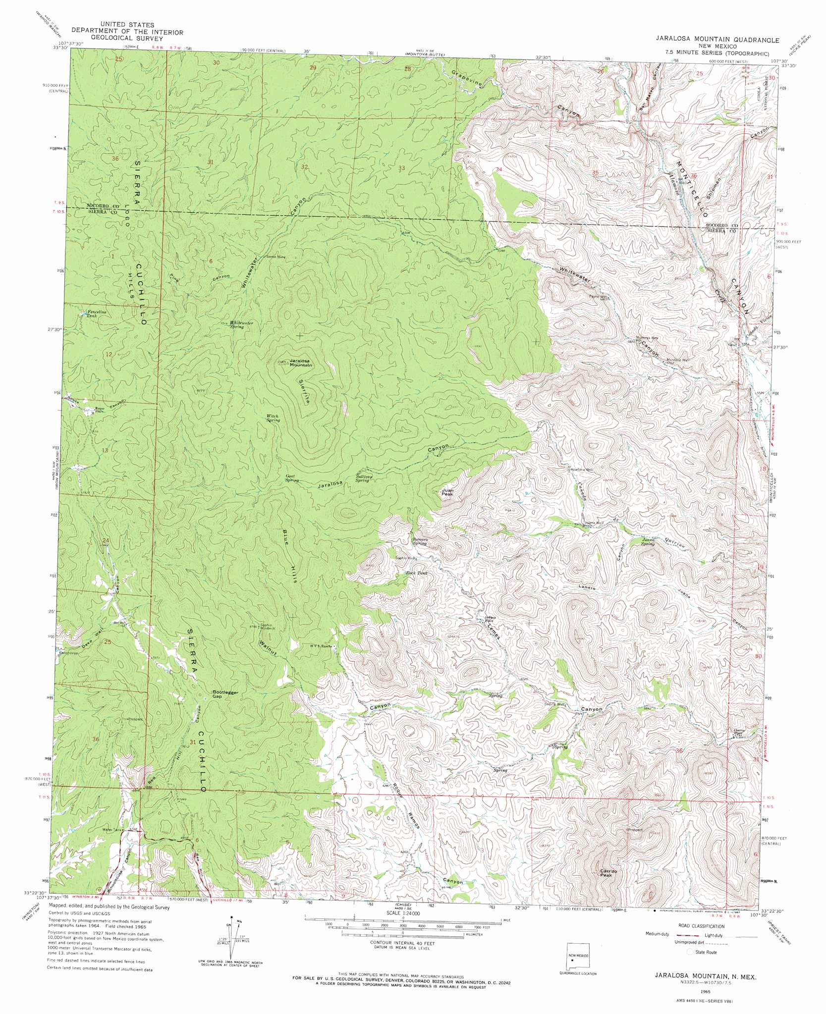
USGS Topo Quad 33107d5 - 1:24,000 scale
| Topo Map Name: | Jaralosa Mountain |
| USGS Topo Quad ID: | 33107d5 |
| Print Size: | ca. 21 1/4" wide x 27" high |
| Southeast Coordinates: | 33.375° N latitude / 107.5° W longitude |
| Map Center Coordinates: | 33.4375° N latitude / 107.5625° W longitude |
| U.S. State: | NM |
| Filename: | o33107d5.jpg |
| Download Map JPG Image: | Jaralosa Mountain topo map 1:24,000 scale |
| Map Type: | Topographic |
| Topo Series: | 7.5´ |
| Map Scale: | 1:24,000 |
| Source of Map Images: | United States Geological Survey (USGS) |
| Alternate Map Versions: |
Jaralosa Mountain NM 1965, updated 1967 Download PDF Buy paper map Jaralosa Mountain NM 1995, updated 1998 Download PDF Buy paper map Jaralosa Mountain NM 2011 Download PDF Buy paper map Jaralosa Mountain NM 2013 Download PDF Buy paper map Jaralosa Mountain NM 2017 Download PDF Buy paper map |
| FStopo: | US Forest Service topo Jaralosa Mountain is available: Download FStopo PDF Download FStopo TIF |
1:24,000 Topo Quads surrounding Jaralosa Mountain
Paddys Hole |
Dusty |
Welty Hill |
Blue Mountain |
San Juan Peak |
Wahoo Peak |
Wahoo Ranch |
Montoya Butte |
Vicks Peak |
Steel Hill |
Sawmill Peak |
Iron Mountain |
Jaralosa Mountain |
Monticello |
Sierra Fijardo |
Lookout Mountain |
Winston |
Chise |
Priest Tank |
Huerfano Hill |
Reeds Peak |
Sugarloaf Peak |
Thumb Tank Peak |
Williamsburg Nw |
Cuchillo |
> Back to 33107a1 at 1:100,000 scale
> Back to 33106a1 at 1:250,000 scale
> Back to U.S. Topo Maps home
Jaralosa Mountain topo map: Gazetteer
Jaralosa Mountain: Arroyos
Cañada Vivian elevation 1698m 5570′Cañada Viviancito elevation 1692m 5551′
Jaralosa Mountain: Gaps
Bootlegger Gap elevation 2189m 7181′Jaralosa Mountain: Mines
Fairview elevation 2272m 7454′Fairview Prospect elevation 2038m 6686′
Serna Mine elevation 2066m 6778′
Jaralosa Mountain: Populated Places
Chaves Place elevation 1751m 5744′Jewkes Place elevation 1872m 6141′
Rouse Place elevation 2294m 7526′
Jaralosa Mountain: Ranges
Loco Hills elevation 2439m 8001′Jaralosa Mountain: Reservoirs
Fenceline Tank elevation 2330m 7644′Rock Tank elevation 1939m 6361′
Jaralosa Mountain: Ridges
Ramos Hills elevation 2016m 6614′Sierrita elevation 2456m 8057′
Jaralosa Mountain: Springs
Goat Spring elevation 2092m 6863′Juana Spring elevation 1803m 5915′
Romero Spring elevation 1940m 6364′
Sullivan Spring elevation 2013m 6604′
Whitewater Spring elevation 2137m 7011′
Witch Spring elevation 2204m 7230′
Jaralosa Mountain: Summits
Blue Hills elevation 2306m 7565′Carrizo Peak elevation 2208m 7244′
Jaralosa Mountain elevation 2530m 8300′
Juan Peak elevation 2234m 7329′
Red Hill elevation 2110m 6922′
Jaralosa Mountain: Valleys
Garcia Falls Canyon elevation 1683m 5521′Grapevine Canyon elevation 1738m 5702′
Jaralosa Canyon elevation 1908m 6259′
Landro Canyon elevation 1800m 5905′
Pine Canyon elevation 2071m 6794′
Red Hill Canyon elevation 2055m 6742′
San Mateo Canyon elevation 1737m 5698′
Shipman Canyon elevation 1716m 5629′
Walnut Canyon elevation 1839m 6033′
Whitewater Canyon elevation 1693m 5554′
Jaralosa Mountain: Wells
Apadoca Well elevation 1851m 6072′Juana Well elevation 1830m 6003′
Montoya Well elevation 1752m 5748′
Montoya Well elevation 1770m 5807′
Payne Well elevation 1792m 5879′
Red Well elevation 2188m 7178′
RG 26392 Water Well elevation 1692m 5551′
RG 26393 Water Well elevation 1708m 5603′
RG 26394 Water Well elevation 1708m 5603′
RG 32700 Water Well elevation 1692m 5551′
Rouse Place Water Well elevation 2292m 7519′
Sedillo Well elevation 1818m 5964′
Sophio Well elevation 1926m 6318′
Jaralosa Mountain digital topo map on disk
Buy this Jaralosa Mountain topo map showing relief, roads, GPS coordinates and other geographical features, as a high-resolution digital map file on DVD: