Indian Peaks East Topo Map New Mexico
To zoom in, hover over the map of Indian Peaks East
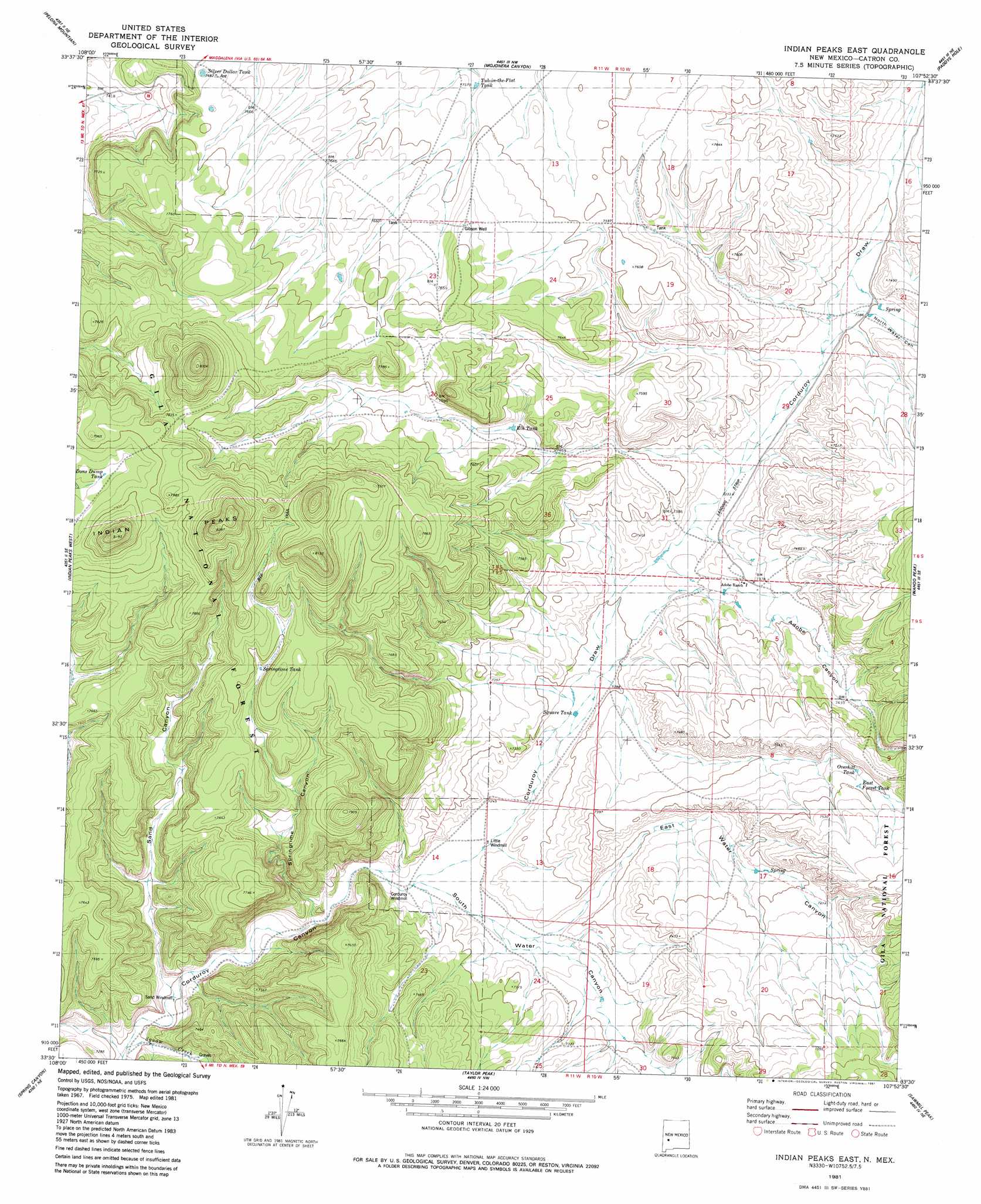
USGS Topo Quad 33107e8 - 1:24,000 scale
| Topo Map Name: | Indian Peaks East |
| USGS Topo Quad ID: | 33107e8 |
| Print Size: | ca. 21 1/4" wide x 27" high |
| Southeast Coordinates: | 33.5° N latitude / 107.875° W longitude |
| Map Center Coordinates: | 33.5625° N latitude / 107.9375° W longitude |
| U.S. State: | NM |
| Filename: | o33107e8.jpg |
| Download Map JPG Image: | Indian Peaks East topo map 1:24,000 scale |
| Map Type: | Topographic |
| Topo Series: | 7.5´ |
| Map Scale: | 1:24,000 |
| Source of Map Images: | United States Geological Survey (USGS) |
| Alternate Map Versions: |
Indian Peaks East NM 1981, updated 1981 Download PDF Buy paper map Indian Peaks East NM 1999, updated 2002 Download PDF Buy paper map Indian Peaks East NM 2011 Download PDF Buy paper map Indian Peaks East NM 2013 Download PDF Buy paper map Indian Peaks East NM 2017 Download PDF Buy paper map |
| FStopo: | US Forest Service topo Indian Peaks East is available: Download FStopo PDF Download FStopo TIF |
1:24,000 Topo Quads surrounding Indian Peaks East
Fullerton |
Shaw Mountain |
Luera Mountains West |
Luera Mountains East |
Oak Peak |
Rail Canyon |
Pelona Mountain |
Mojonera Canyon |
Paddys Hole |
Dusty |
O Bar O Canyon East |
Indian Peaks West |
Indian Peaks East |
Wahoo Peak |
Wahoo Ranch |
Black Mountain |
Spring Canyon |
Taylor Peak |
Sawmill Peak |
Iron Mountain |
Burnt Corral Canyon |
Wall Lake |
Baily Points |
Lookout Mountain |
Winston |
> Back to 33107e1 at 1:100,000 scale
> Back to 33106a1 at 1:250,000 scale
> Back to U.S. Topo Maps home
Indian Peaks East topo map: Gazetteer
Indian Peaks East: Airports
Adobe Ranch Private Airport elevation 2237m 7339′Indian Peaks East: Mines
Hiawatha Mine elevation 2248m 7375′Indian Peaks East: Reservoirs
East Forest Tank elevation 2286m 7500′Elk Tank elevation 2289m 7509′
Overhill Tank elevation 2280m 7480′
Peaks Tank elevation 2388m 7834′
Silver Dollar Tank elevation 2337m 7667′
Springtime Tank elevation 2334m 7657′
Square Tank elevation 2216m 7270′
Tub-in-the-Flat Tank elevation 2304m 7559′
Indian Peaks East: Streams
Squaw Creek elevation 2190m 7185′Indian Peaks East: Valleys
Adobe Canyon elevation 2221m 7286′Corduroy Draw elevation 2207m 7240′
East Water Canyon elevation 2209m 7247′
North Water Canyon elevation 2258m 7408′
Sand Canyon elevation 2195m 7201′
Sawmill Canyon elevation 2208m 7244′
South Water Canyon elevation 2207m 7240′
South Water Canyon elevation 2207m 7240′
Springtime Canyon elevation 2204m 7230′
Indian Peaks East: Wells
Gibson Well elevation 2342m 7683′Indian Peaks East digital topo map on disk
Buy this Indian Peaks East topo map showing relief, roads, GPS coordinates and other geographical features, as a high-resolution digital map file on DVD: