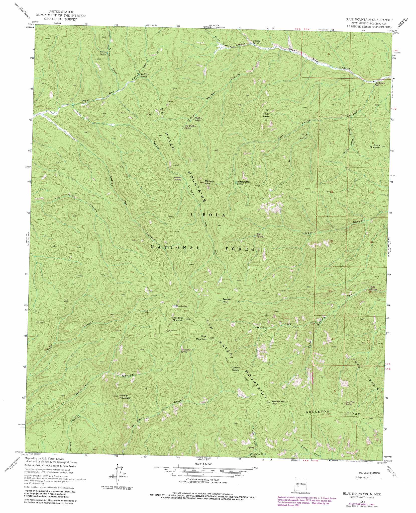
Blue Mountain Topo Map New Mexico
To zoom in, hover over the map of Blue Mountain
USGS Topo Quad 33107f4 - 1:24,000 scale
| Topo Map Name: | Blue Mountain |
| USGS Topo Quad ID: | 33107f4 |
| Print Size: | ca. 21 1/4" wide x 27" high |
| Southeast Coordinates: | 33.625° N latitude / 107.375° W longitude |
| Map Center Coordinates: | 33.6875° N latitude / 107.4375° W longitude |
| U.S. State: | NM |
| Filename: | o33107f4.jpg |
| Download Map JPG Image: | Blue Mountain topo map 1:24,000 scale |
| Map Type: | Topographic |
| Topo Series: | 7.5´ |
| Map Scale: | 1:24,000 |
| Source of Map Images: | United States Geological Survey (USGS) |
| Alternate Map Versions: |
Blue Mountain NM 1964, updated 1966 Download PDF Buy paper map Blue Mountain NM 1964, updated 1978 Download PDF Buy paper map Blue Mountain NM 1964, updated 1981 Download PDF Buy paper map Blue Mountain NM 1964, updated 1981 Download PDF Buy paper map Blue Mountain NM 1995, updated 1998 Download PDF Buy paper map Blue Mountain NM 2011 Download PDF Buy paper map Blue Mountain NM 2013 Download PDF Buy paper map Blue Mountain NM 2017 Download PDF Buy paper map |
| FStopo: | US Forest Service topo Blue Mountain is available: Download FStopo PDF Download FStopo TIF |
1:24,000 Topo Quads surrounding Blue Mountain
Kellog Well |
Monica Saddle |
Mount Withington |
Squaw Peak |
South Baldy |
Oak Peak |
Bay Buck Peaks |
Grassy Lookout |
Tenmile Hill |
Puertecito Gap |
Dusty |
Welty Hill |
Blue Mountain |
San Juan Peak |
Hickman Ranch |
Wahoo Ranch |
Montoya Butte |
Vicks Peak |
Steel Hill |
Black Hill |
Iron Mountain |
Jaralosa Mountain |
Monticello |
Sierra Fijardo |
Romero Canyon |
> Back to 33107e1 at 1:100,000 scale
> Back to 33106a1 at 1:250,000 scale
> Back to U.S. Topo Maps home
Blue Mountain topo map: Gazetteer
Blue Mountain: Forests
Magdalena Ranger District elevation 2577m 8454′Blue Mountain: Gaps
Bull Saddle elevation 2711m 8894′Cyclone Saddle elevation 2897m 9504′
Blue Mountain: Ranges
San Mateo Mountains elevation 2397m 7864′Blue Mountain: Ridges
Skeleton Ridge elevation 2756m 9041′Blue Mountain: Springs
Alexander Spring elevation 2802m 9192′Bull Springs elevation 2310m 7578′
Cold Spring elevation 2082m 6830′
Cow Trap Spring elevation 2648m 8687′
Cub Spring elevation 3011m 9878′
Hardscrabble Spring elevation 2298m 7539′
Hidden Spring elevation 2209m 7247′
Indian Spring elevation 2319m 7608′
Old Hidden Spring elevation 2251m 7385′
Pothole Spring elevation 2388m 7834′
Tool Box Spring elevation 2296m 7532′
Turkey Springs elevation 2052m 6732′
Twentyfive Yard Spring elevation 2643m 8671′
Blue Mountain: Streams
Indian Creek elevation 2267m 7437′Blue Mountain: Summits
Apache Kid Peak elevation 3065m 10055′Black Mountain elevation 2306m 7565′
Blue Mountain elevation 3135m 10285′
Cave Peaks elevation 2426m 7959′
Holdup Mountain elevation 2828m 9278′
Milligan Peak elevation 2666m 8746′
Teepee Peak elevation 3029m 9937′
West Blue Mountain elevation 3144m 10314′
Blue Mountain: Valleys
Allen Spring Canyon elevation 2037m 6683′Bull Canyon elevation 2040m 6692′
Coffee Pot Canyon elevation 2218m 7276′
Drift Fence Canyon elevation 1930m 6332′
Hidden Springs Canyon elevation 2012m 6601′
Water Canyon elevation 2235m 7332′
West Fork Cold Spring Canyon elevation 2181m 7155′
Yellow Jacket Canyon elevation 1976m 6482′
Blue Mountain: Wells
Drift Fence Well elevation 1941m 6368′East Red Well elevation 1931m 6335′
Blue Mountain digital topo map on disk
Buy this Blue Mountain topo map showing relief, roads, GPS coordinates and other geographical features, as a high-resolution digital map file on DVD: