Puertecito Gap Topo Map New Mexico
To zoom in, hover over the map of Puertecito Gap
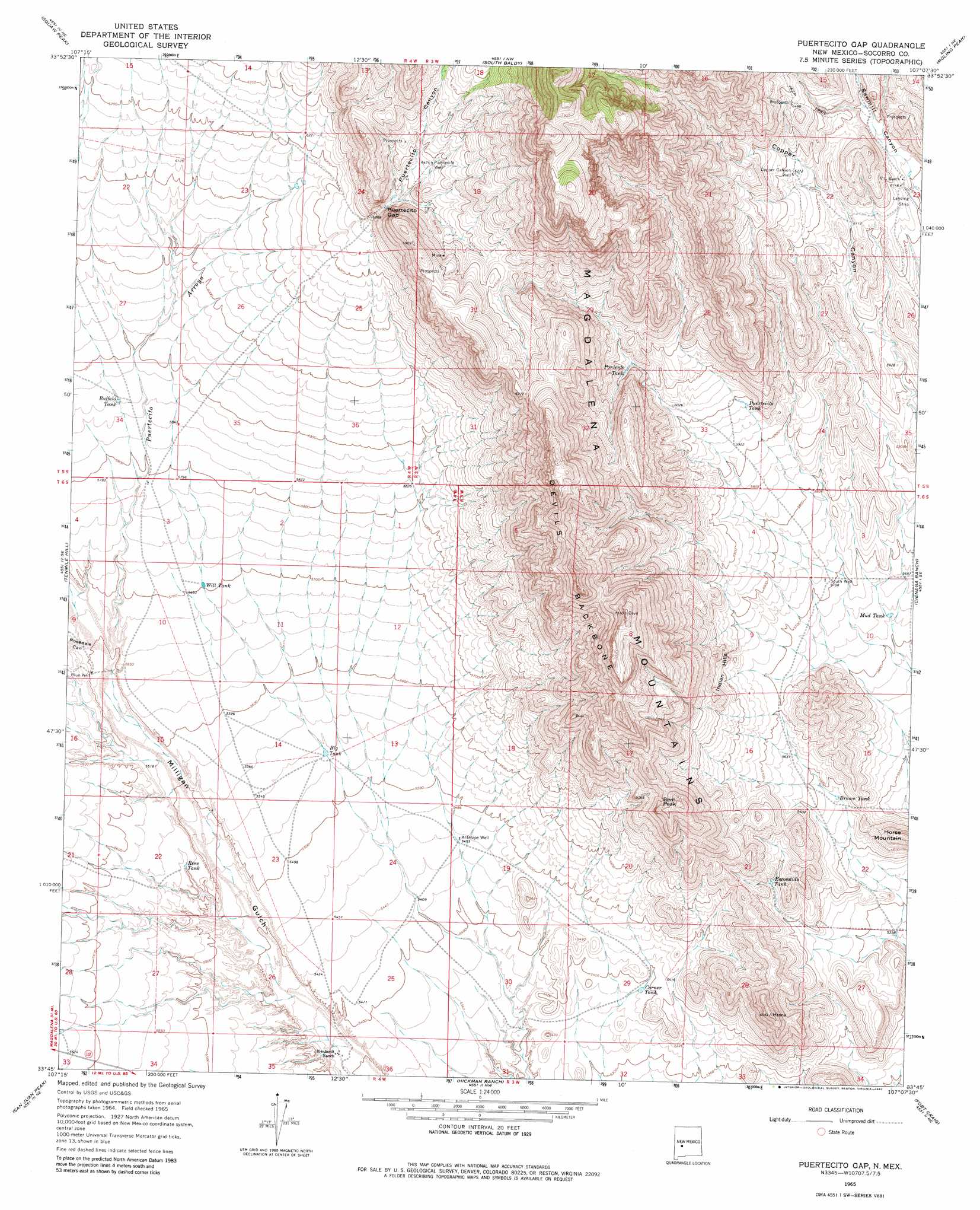
USGS Topo Quad 33107g2 - 1:24,000 scale
| Topo Map Name: | Puertecito Gap |
| USGS Topo Quad ID: | 33107g2 |
| Print Size: | ca. 21 1/4" wide x 27" high |
| Southeast Coordinates: | 33.75° N latitude / 107.125° W longitude |
| Map Center Coordinates: | 33.8125° N latitude / 107.1875° W longitude |
| U.S. State: | NM |
| Filename: | o33107g2.jpg |
| Download Map JPG Image: | Puertecito Gap topo map 1:24,000 scale |
| Map Type: | Topographic |
| Topo Series: | 7.5´ |
| Map Scale: | 1:24,000 |
| Source of Map Images: | United States Geological Survey (USGS) |
| Alternate Map Versions: |
Puertecito Gap NM 1965, updated 1968 Download PDF Buy paper map Puertecito Gap NM 1965, updated 1982 Download PDF Buy paper map Puertecito Gap NM 2010 Download PDF Buy paper map Puertecito Gap NM 2013 Download PDF Buy paper map Puertecito Gap NM 2017 Download PDF Buy paper map |
| FStopo: | US Forest Service topo Puertecito Gap is available: Download FStopo PDF Download FStopo TIF |
1:24,000 Topo Quads surrounding Puertecito Gap
Tres Montosas |
Arroyo Landavaso |
Magdalena |
Water Canyon |
Socorro |
Mount Withington |
Squaw Peak |
South Baldy |
Molino Peak |
Luis Lopez |
Grassy Lookout |
Tenmile Hill |
Puertecito Gap |
Cienega Ranch |
Indian Well Wilderness |
Blue Mountain |
San Juan Peak |
Hickman Ranch |
Fort Craig |
San Marcial |
Vicks Peak |
Steel Hill |
Black Hill |
Paraje Well |
Pope |
> Back to 33107e1 at 1:100,000 scale
> Back to 33106a1 at 1:250,000 scale
> Back to U.S. Topo Maps home
Puertecito Gap topo map: Gazetteer
Puertecito Gap: Arroyos
Puertecito Arroyo elevation 1705m 5593′Puertecito Gap: Gaps
Puertecito Gap elevation 1928m 6325′Puertecito Gap: Mines
Magnum Claims elevation 2040m 6692′Weston Ranch Mine elevation 1997m 6551′
Weston Ranch Mine elevation 2040m 6692′
Puertecito Gap: Reservoirs
Big Tank elevation 1685m 5528′Brown Tank elevation 1697m 5567′
Buffalo Tank elevation 1787m 5862′
Corner Tank elevation 1641m 5383′
Escondido Tank elevation 1701m 5580′
Mud Tank elevation 1716m 5629′
Poniente Tank elevation 1879m 6164′
Puertecito Tank elevation 1823m 5980′
Rene Tank elevation 1685m 5528′
Will Tank elevation 1738m 5702′
Puertecito Gap: Ridges
Devils Backbone elevation 2223m 7293′Puertecito Gap: Summits
Bern Peak elevation 1996m 6548′Horse Mountain elevation 1784m 5853′
Indian Hills elevation 1773m 5816′
Puertecito Gap: Valleys
Puertecito Canyon elevation 1915m 6282′Rosedale Canyon elevation 1707m 5600′
Puertecito Gap: Wells
10052 Water Well elevation 1742m 5715′Antelope Well elevation 1662m 5452′
Blue Well elevation 1707m 5600′
Copper Canyon Well elevation 1912m 6272′
Puertecito Well elevation 1971m 6466′
South Well elevation 1741m 5711′
Puertecito Gap digital topo map on disk
Buy this Puertecito Gap topo map showing relief, roads, GPS coordinates and other geographical features, as a high-resolution digital map file on DVD: