North Star Mesa Topo Map New Mexico
To zoom in, hover over the map of North Star Mesa
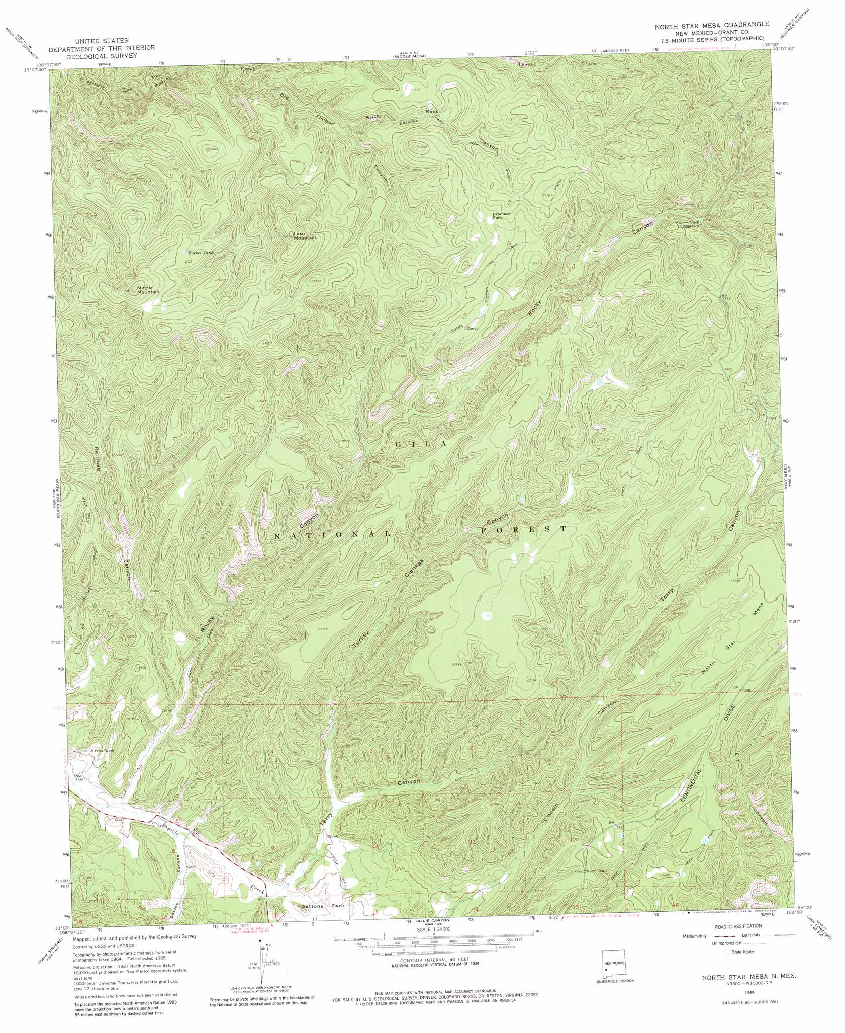
USGS Topo Quad 33108a1 - 1:24,000 scale
| Topo Map Name: | North Star Mesa |
| USGS Topo Quad ID: | 33108a1 |
| Print Size: | ca. 21 1/4" wide x 27" high |
| Southeast Coordinates: | 33° N latitude / 108° W longitude |
| Map Center Coordinates: | 33.0625° N latitude / 108.0625° W longitude |
| U.S. State: | NM |
| Filename: | o33108a1.jpg |
| Download Map JPG Image: | North Star Mesa topo map 1:24,000 scale |
| Map Type: | Topographic |
| Topo Series: | 7.5´ |
| Map Scale: | 1:24,000 |
| Source of Map Images: | United States Geological Survey (USGS) |
| Alternate Map Versions: |
North Star Mesa NM 1965, updated 1969 Download PDF Buy paper map North Star Mesa NM 1965, updated 1980 Download PDF Buy paper map North Star Mesa NM 1999, updated 2002 Download PDF Buy paper map North Star Mesa NM 2011 Download PDF Buy paper map North Star Mesa NM 2013 Download PDF Buy paper map North Star Mesa NM 2017 Download PDF Buy paper map |
| FStopo: | US Forest Service topo North Star Mesa is available: Download FStopo PDF Download FStopo TIF |
1:24,000 Topo Quads surrounding North Star Mesa
Woodland Park |
Burnt Corral Canyon |
Wall Lake |
Baily Points |
Lookout Mountain |
Little Turkey Park |
Gila Hot Springs |
Middle Mesa |
Bonner Canyon |
Reeds Peak |
Granny Mountain |
Copperas Peak |
North Star Mesa |
Hay Mesa |
Victoria Park |
Reading Mountain |
Twin Sisters |
Allie Canyon |
Hendricks Peak |
Hillsboro Peak |
Silver City |
Fort Bayard |
Santa Rita |
San Lorenzo |
Maverick Mountain |
> Back to 33108a1 at 1:100,000 scale
> Back to 33108a1 at 1:250,000 scale
> Back to U.S. Topo Maps home
North Star Mesa topo map: Gazetteer
North Star Mesa: Parks
Brannon Park elevation 2278m 7473′North Star Mesa: Reservoirs
Big Timber Tank elevation 2258m 7408′Boundary Tank elevation 2139m 7017′
Bucket Tank elevation 2304m 7559′
Canyon Tank elevation 2153m 7063′
Clear Tank elevation 2262m 7421′
ET Tank Number Two elevation 2222m 7290′
Fork Stock Tank elevation 2315m 7595′
Gravel Tank elevation 2159m 7083′
Heifer Tank elevation 2175m 7135′
Hub Tank elevation 2171m 7122′
Loco Tank elevation 2241m 7352′
Maverick Tank elevation 2227m 7306′
McKenna Mesa Tank elevation 2237m 7339′
North Star Tank elevation 2198m 7211′
Saddle Tank elevation 2121m 6958′
Skates Tank elevation 2093m 6866′
Skates Tank Number One elevation 1924m 6312′
Skates Tank Number Two elevation 1899m 6230′
Slow Tank elevation 2118m 6948′
Terry Tank Number Three elevation 2180m 7152′
Turkey Cienega Tank elevation 2201m 7221′
Wayne Tank elevation 2226m 7303′
North Star Mesa: Ridges
North Star Mesa elevation 2247m 7372′North Star Mesa: Springs
Brannon Spring elevation 2227m 7306′Railroad Spring elevation 2094m 6870′
North Star Mesa: Summits
Loco Mountain elevation 2427m 7962′Middle Mountain elevation 2391m 7844′
North Star Mesa: Trails
Brannon Park Trail elevation 1982m 6502′Rocky Canyon Trail elevation 2244m 7362′
North Star Mesa: Valleys
Big Timber Canyon elevation 2072m 6797′Railroad Canyon elevation 1912m 6272′
Rocky Canyon elevation 1882m 6174′
Skates Canyon elevation 1895m 6217′
Slick Rock Canyon elevation 2142m 7027′
Terry Canyon elevation 1926m 6318′
Turkey Cienega Canyon elevation 1959m 6427′
North Star Mesa: Wells
Red Sap Well elevation 1913m 6276′Terry Well elevation 1951m 6400′
North Star Mesa digital topo map on disk
Buy this North Star Mesa topo map showing relief, roads, GPS coordinates and other geographical features, as a high-resolution digital map file on DVD: