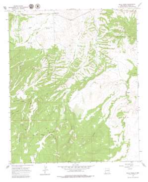
Mule Creek Topo Map New Mexico
To zoom in, hover over the map of Mule Creek
USGS Topo Quad 33108a8 - 1:24,000 scale
| Topo Map Name: | Mule Creek |
| USGS Topo Quad ID: | 33108a8 |
| Print Size: | ca. 21 1/4" wide x 27" high |
| Southeast Coordinates: | 33° N latitude / 108.875° W longitude |
| Map Center Coordinates: | 33.0625° N latitude / 108.9375° W longitude |
| U.S. State: | NM |
| Filename: | o33108a8.jpg |
| Download Map JPG Image: | Mule Creek topo map 1:24,000 scale |
| Map Type: | Topographic |
| Topo Series: | 7.5´ |
| Map Scale: | 1:24,000 |
| Source of Map Images: | United States Geological Survey (USGS) |
| Alternate Map Versions: |
Mule Creek NM 1965, updated 1969 Download PDF Buy paper map Mule Creek NM 1999, updated 2002 Download PDF Buy paper map Mule Creek NM 2011 Download PDF Buy paper map Mule Creek NM 2013 Download PDF Buy paper map Mule Creek NM 2017 Download PDF Buy paper map |
| FStopo: | US Forest Service topo Mule Creek is available: Download FStopo PDF Download FStopo TIF |
1:24,000 Topo Quads surrounding Mule Creek
> Back to 33108a1 at 1:100,000 scale
> Back to 33108a1 at 1:250,000 scale
> Back to U.S. Topo Maps home
Mule Creek topo map: Gazetteer
Mule Creek: Parks
Hell Hole Wilderness Study Area elevation 1918m 6292′Mule Creek: Populated Places
Mule Creek elevation 1595m 5232′Mule Creek: Ranges
Mule Mountains elevation 1903m 6243′Mule Creek: Reservoirs
Ball Park Tank elevation 1905m 6250′Bastard Basin Tank elevation 2075m 6807′
Boiling Tank elevation 1768m 5800′
Bradberry Tank elevation 1833m 6013′
Cattle Guard Tank elevation 1914m 6279′
Corner Tank elevation 1969m 6459′
East Walnut Tank elevation 1775m 5823′
East Wilkinson Tank elevation 1912m 6272′
Hardluck Tank elevation 1804m 5918′
Johnson Tank elevation 1968m 6456′
Juniper Tank elevation 1910m 6266′
McDonald Tank elevation 1866m 6122′
Mount Owens Tank elevation 1912m 6272′
Pasture Tank elevation 1853m 6079′
Racetrack Tank elevation 1971m 6466′
Roadside Tank elevation 1793m 5882′
Round Mountain Tank elevation 1930m 6332′
Smith Mountain Tank elevation 1869m 6131′
South Fork Tank elevation 1734m 5688′
Sparaque Tank elevation 2010m 6594′
Steer Pasture Tank elevation 1865m 6118′
Trail Tank elevation 1868m 6128′
Wilkinson Tank elevation 1867m 6125′
Mule Creek: Springs
Dripping Spring elevation 1658m 5439′Mule Spring elevation 1630m 5347′
Tennessee Spring elevation 1636m 5367′
Walnut Spring elevation 1693m 5554′
Mule Creek: Summits
Sunflower Mesa elevation 1872m 6141′Mule Creek: Valleys
Bathtub Canyon elevation 1686m 5531′Boiling Canyon elevation 1630m 5347′
Buckhorn Draw elevation 1735m 5692′
North Sawmill Canyon elevation 1767m 5797′
Racetrack Canyon elevation 1801m 5908′
Smith Canyon elevation 1779m 5836′
Sprague Canyon elevation 1723m 5652′
Walnut Canyon elevation 1648m 5406′
Mule Creek: Wells
Mule Creek Well elevation 1623m 5324′Sawmill Well elevation 1766m 5793′
Mule Creek digital topo map on disk
Buy this Mule Creek topo map showing relief, roads, GPS coordinates and other geographical features, as a high-resolution digital map file on DVD:


